Esclanèdes
| Esclanèdes | |
|---|---|
|
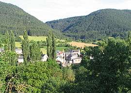
Esclanèdes in the Lot valley | |
 Esclanèdes | |
|
Location within Occitanie region  Esclanèdes | |
| Coordinates: 44°28′57″N 3°21′44″E / 44.48250°N 3.3622°ECoordinates: 44°28′57″N 3°21′44″E / 44.48250°N 3.3622°E | |
| Country | France |
| Region | Occitanie |
| Department | Lozère |
| Arrondissement | Mende |
| Canton | Chanac |
| Intercommunality | Pays de Chanac |
| Government | |
| • Mayor (2001–2008) | Bernard Pinot |
| Area1 | 12.51 km2 (4.83 sq mi) |
| Population (1999)2 | 250 |
| • Density | 20/km2 (52/sq mi) |
| Time zone | CET (UTC+1) |
| • Summer (DST) | CEST (UTC+2) |
| INSEE/Postal code | 48056 / 48230 |
| Elevation |
627–1,001 m (2,057–3,284 ft) (avg. 643 m or 2,110 ft) |
|
1 French Land Register data, which excludes lakes, ponds, glaciers > 1 km² (0.386 sq mi or 247 acres) and river estuaries. 2 Population without double counting: residents of multiple communes (e.g., students and military personnel) only counted once. | |
Esclanèdes is a commune in the Lozère department in southern France.
Its inhabitants are known as Esclanédiens.
Geography
The main part of the commune is located in the Lot valley, whereas the rest is on the Causse of Sauveterre. The town hall is located in the biggest burg called Le Bruel, on the north side of the river. Esclanèdes is named after the burg situated on the north side and where is located the church. Other inhabited places are the small burgs of Les Crottes et la Rocherousse and the two farms of Marance and Le Mazet.
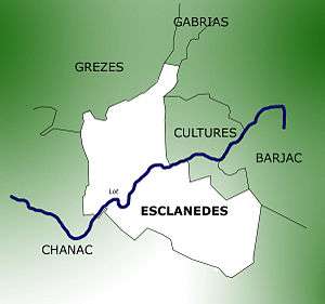
The adjoining communes are the following:
- Chanac on the southwest side
- Grèzes on the north side
- Cultures on the east side
- Gabrias on the northeast side
- Barjac on the northeast and southeast sides
Administration
The current mayor is Bernard Pinot. He was re-elected in 2008.
Demographics
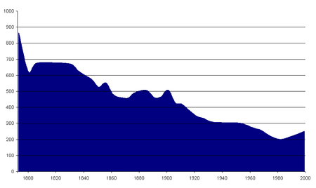
Between 1990 and 1999:
- Population in 1990: 217
- Population in 1999: 250
- Natural increase: - 2
- Net migration: + 35
- Population growth: + 33
- Average variation rate of the population by year: +1,5%
See also
External links
Sights
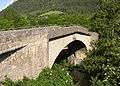 Esclanèdes bridge
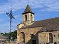 Saint-Hippolyte church
| Wikimedia Commons has media related to Esclanèdes. |