Cantal
| Cantal | |||
|---|---|---|---|
| Department | |||
|
Prefecture building of the Cantal department, in Aurillac | |||
| |||
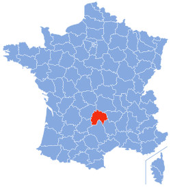 Location of Cantal in France | |||
| Coordinates: 45°2′N 3°6′E / 45.033°N 3.100°ECoordinates: 45°2′N 3°6′E / 45.033°N 3.100°E | |||
| Country | France | ||
| Region | Auvergne-Rhône-Alpes | ||
| Prefecture | Aurillac | ||
| Subprefectures |
Mauriac Saint-Flour | ||
| Government | |||
| • President of the General Council | Vincent Descoeur (UMP) | ||
| Area1 | |||
| • Total | 5,726 km2 (2,211 sq mi) | ||
| Population (2013) | |||
| • Total | 147,035 | ||
| • Rank | 97th | ||
| • Density | 26/km2 (67/sq mi) | ||
| Time zone | CET (UTC+1) | ||
| • Summer (DST) | CEST (UTC+2) | ||
| Department number | 15 | ||
| Arrondissements | 3 | ||
| Cantons | 15 | ||
| Communes | 255 | ||
| ^1 French Land Register data, which exclude estuaries, and lakes, ponds, and glaciers larger than 1 km2 | |||


Cantal (French pronunciation: [kɑ̃.tal]) is a department in south-central France, with its capital at Aurillac. Its residents are known as Cantalians (French: Cantaliens or Cantalous). Its principal towns are Aurillac, Saint-Flour, and Mauriac. Cantal is part of the current region of Auvergne-Rhône-Alpes and borders the departments of Puy-de-Dôme, Haute-Loire, Aveyron, Lot, Lozère, and Corrèze. Along with Lozère and Creuse, Cantal is among the most sparsely populated and geographically isolated French departments and Aurillac is the departmental capital farthest removed from a major motorway.
Name
The department is named for the Plomb du Cantal, the central peak of the bare and rugged Monts du Cantal mountain chain which traverses the area.[1]
Geography
Cantal lies in the middle of France's central plateau.[2] The Cantal range is a group of extinct and eroded volcanic peaks. Its highest point is the Plomb du Cantal, which reaches an elevation of 1,858 meters (6,096 ft). Its neighbors are Puy Mary (elev. 1,787 meters or 5,863 feet) and Puy Chavaroche (elev. 5,722 feet or 1,744 meters). To their north lie the Cézallier and Dore ranges and the arid Artense Plateau. Immediately to their east is the fertile Planèze Plateau, bound on its east by the Monts de la Margeride.[2] The principal rivers are the Alagnon, which is tributary to the Allier; the Celle and Truyère, tributary to the Lot; and the Cere and Rhue, tributary to the Dordogne.[1] At an elevation of 250 meters (820 ft) above sea level, the low point of the province lies in the Lot valley. The Truyère valley skirts the Planèze on the south and divides it from the Monts d'Aubrac, whose foothills include the thermal springs of Chaudesaigues. The western area of the department consists of grassy plateaus and beautiful river valleys.[2]
At first, Cantal was divided into four arrondissements—Aurillac, Mauriac, Murat, and St-Flour.[1][2] Murat was later merged into the others.
Climate
The climate of the department varies considerably.[1] Prevailing winds and mountain ranges divide Cantal into four climatic zones:
- The west is subject to oceanic winds which bring rains.
- The mountains of the Cantal and the Cézallier create a rain shadow: it rains and snows quite often.
- The Planèze of Saint-Flour and the region of Massiac receive less precipitation, owing to winds coming from the north and south.
- The plateaux of the Margeride and the Aubrac have harsh winters and pleasant summers.
Generally, the weather is mild and dry in the alluvial plain between Murat and St-Fleur and around Aurillac, while summer storms and winters can be long and severe in the northern and central areas.[1] The west—nearer precipitation coming in from the Atlantic—is well watered. There is abundant snowfall which can remain up to six months on the mountaintops. Winter temperatures can fall to below −15 °C (5 °F), whereas in summer 25 °C (77 °F) is often reached. The southern part of the department, on its borders with Aveyron and Lot, is the hottest region. Aurillac averaged 2080 hours of sunlight per year over the period from 1991 to 2000. Fog is rare and disappears quickly. Wind is usually not very strong, but the lightning flashes in this department are among the most spectacular in France.
Televised French weather forecasts often note Aurillac as the coldest city in France in the mornings. This status should be understood in light of their derivation from temperature readings by Météo France. Of the 30 cities included on its maps, Aurillac is by far the one with the highest altitude, at 640 m (2,100 ft) above sea level.
History
The area of Cantal was historically part of the southern, upper area of Auvergne (Haute-Auvergne).[1][2]
Cantal is one of the original 83 departments created during the French Revolution on 4 March 1790. Prior to the First World War, it comprised parts of the XIII. Army Corps military region and the Clermont-Ferrand educational division (académie).[2]
Economy
The climate being generally too cool and damp for grain, much of Cantal is given over to pasture for Aubrac and Salers cattle, sheep, and, formerly, horses. This in turn supports a dairy industry responsible for butter and Roquefort cheese[1] and the appellation-controlled cheeses Cantal, Salers, and Bleu d'Auvergne. Cantal is the French department with the greatest number of appellation-controlled cheeses,[3] although proper Roquefort is now restricted to cheese produced in the Aveyron department. The region's mineral products include coal, copper, lead, iron, antimony, granite, slate,[1] and lime,[2] but the department's isolation and poor infrastructure long precluded their exploitation.[1] Before the First World War, the primary exports were livestock, cheese, butter, and coal and the main imports were coal, wine, grain, flour, and pottery. By then, it had been connected to both the Orleans and Midi railways.[2]
Traditionally, many Cantalians roamed France during the year plying humble trades[1][2] but now the area's relative lack of industry and development permits tourism. An area has been set aside as the Auvergne Volcanos Regional Park (Parc Regional des Volcans d’Auvergne).
Demographics
Cantal was historically dominated by the Occitan language.
The official population count for 2013 was 147,000.[4] The population peaked at 262,117 in 1836. It has been below 200,000 for the last 90 years. The department has experienced a particularly drastic level of depopulation, although the phenomenon was a feature of many of the country's rural departments throughout the twentieth century, as agricultural wages failed to keep pace with those available in the industrialising regions outside the department.
Tourism
Architecture
The department counts several remarkable buildings. Among them, the Romanesque religious buildings like the churches of Cheylade (eleventh century), Dieno or Massiac. The area's Catholic cathedral—dependent on the archdiocese of Bourges—is the 15th-century St Pierre de St-Flour,[2] erected in the Gothic style.
- Castle of Val in Lanobre (36,500 visitors/year)
- Castle of Anjony in Tournemire (20,000 visitors/year)
- Castle of Pesteils in Polminhac (11,700 visitors/year)
- Castle de la Vigne in Ally (6,000 visitors/year)
- Castle of Clavières in Ayrens
- Castle of Carbonat in Arpajon-sur-Cère
- Chateau de Conros, near Aurillac
Festivals
- International Festival of Street Theatre, Aurillac.
- World Music Festival, Murat
- 36 hours : Various little scenes with dances
Art
The characteristic folk dance in Cantal is La Bourée. In the countryside it would be danced in folk costumes with accompaniment by accordion. The dance form was long ago adapted for use in courtly music and features prominently in the Baroque dance suites of the seventeenth and eighteenth centuries.
Prominent museums in Cantal include:
- Museum of Art and Arqueologia, Aurillac (34,100 visitors/year)
- The House of Fauna, Murat (23,500 visitors/year)
- Museum of the Géothermia, Calores-Agudo (20,600 visitors/year)
- Museum of the Volcanos, Aurillac (20,100 visitors/year)
- Museum of the ray, Marcenat (11,500 visitors/year)
- Museum of the "Haute Auvergne", Saint-Flour (11,100 visitors/year)
- The House of the Chestnut Mourjou (5,200 visitors/year)
- Museum of Georges Pompidou, Montboudif (3,500 visitors/year)
- Museum of the Accordion in Siran
- Museum of Agriculture in Auvernia, Coltines
Cuisine
The traditional articles of Cantalian cuisine were rye, buckwheat, and chestnuts,[1] as well as ham, cheese, and vegetables. The area's simple recipes were designed to satisfy hill farmers and herders. Notable dishes include:
- The Aligot (also in Aveyron): Creamed potatoes, cheese (fresh tomme), butter, fresh cream and a little garlic.
- The Truffade: Potatoes in slices with cheese (fresh tomme) and a little garlic.
- The Pounti: A cake made with dough of wheat black flour, herbs, lard, prunes and Swiss chard.
- The typical cheese Cantal, which can be chosen young, old or "entre-deux".
Outdoor activities
In the 19th century, the hills and valleys abounded with game and the streams with fish, the countryside producing a "vast variety" of aromatic and medicinal plants.[1]
At present, the most visited places are Puy Mary, considered to be one of the prettiest panoramas in Europe, the Plomb du Cantal, the village of Salers, and the gorges of the Truyère (with the Garabit viaduct, the castle of Alleuze, and the towns of Boisset, Pierrefort). The Parc Naturel des Volcans d’Auvergne features several inactive volcanoes. Cantal also has numerous castles. Puy Mary can be accessed by car easily. and is accessible to hikers. It is also possible to hike to the nearby Puy de Peyre-Arse(1806m). Le Lioran or Super-Lioran are the best places to start the hike. Le Lioran is accessible by rail or bus and Super-Lioran is just a kilometre away from Le Lioran. From Super-Lioran it is also possible to hike to Plomb du Cantal. There is also an option of taking the cable car to Plomb du Cantal from Super-Lioran. Super-Lioran tourist office has various hike routes in the region. There are also various adventure courses, dirt bikes, summer luges etc. that run in Super-Lioran.
Among the various activities offered in this department, the "Massif Cantalien" can be discovered through walking, horseback riding or mountain biking excursions (tracks are especially designed for this). Aquatic sports are also popular, thanks to numerous lakes. The department also offers more classical activities such as mountaineering, canoeing and fishing. The landscape also allows the practice of free flight: base jumpers frequent the sector around the Puy Mary and the Brezon valley.
Thanks to its terrain, Cantal can count on a good snow level, which allows winter sports. The station of Le Lioran, largest ski-resort of the Massif Central offers alpine skiing (with specific adaptations for snowboard) and ice-skating. Excursions in snow shoes are also possible. The department has several hundred kilometres of cross-country skiing tracks.


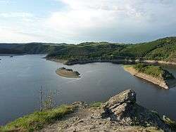
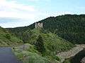 Truyère river and Château d'Alleuze
 Railway bridge designed by Gustav Eiffel (Garabit viaduct)
 Cantal hills
Politics
This staunchly Catholic department is an old stronghold of the French Right and was the electoral base of the late Georges Pompidou. Only the area around Aurillac, historically anti-clerical and Radical, has some left-wing support.
The current president of the general council is Vincent Descoeur of the Union for a Popular Movement, presently the main opposition party in France.
Paul Doumer, French president from May 1931 to May 1932, was born in Aurillac in this department.
| Party | seats | |
|---|---|---|
| • | Union for a Popular Movement | 13 |
| Socialist Party | 5 | |
| • | Miscellaneous Right | 5 |
| Miscellaneous Left | 3 | |
| • | MoDem | 1 |
References
Citations
Bibliography
- "Cantal", Encyclopædia Britannica, 9th ed., Vol. V, New York: Charles Scribner's Sons, 1878, pp. 27–28.
- "Cantal", Encyclopædia Britannica, 11th ed., Vol. V, Cambridge: Cambridge University Press, 1911, p. 208.
External links
| Wikimedia Commons has media related to Cantal. |
- (French) Prefecture website
- (French) General Council website
- (English) Cantal at DMOZ
- (English) Cantal Tourism website