Ascot Corner, Quebec
| Ascot Corner | |
|---|---|
| Municipality | |
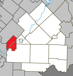
 Location within Le Haut-Saint-François RCM. | |
 Ascot Corner Location in southern Quebec. | |
| Coordinates: 45°27′N 71°46′W / 45.450°N 71.767°WCoordinates: 45°27′N 71°46′W / 45.450°N 71.767°W[1] | |
| Country |
|
| Province |
|
| Region | Estrie |
| RCM | Le Haut-Saint-François |
| Constituted | March 28, 1901 |
| Government[2] | |
| • Mayor | Nathalie Bresse |
| • Federal riding | Compton—Stanstead |
| • Prov. riding | Mégantic |
| Area[2][3] | |
| • Total | 85.20 km2 (32.90 sq mi) |
| • Land | 82.47 km2 (31.84 sq mi) |
| Population (2011)[3] | |
| • Total | 2,891 |
| • Density | 35.1/km2 (91/sq mi) |
| • Pop 2006-2011 |
|
| Time zone | EST (UTC−5) |
| • Summer (DST) | EDT (UTC−4) |
| Postal code(s) | J0B 1A0 |
| Area code(s) | 819 |
| Highways |
|
| Website |
www |
Ascot Corner (2011 population 2,891) is a municipality in Le Haut-Saint-François Regional County Municipality in the Estrie region of Quebec.
Demographics
Population
| Canada census – Ascot Corner, Quebec community profile | |||
|---|---|---|---|
| 2011 | 2006 | 2001 | |
| Population: | 2,891 (+11.4% from 2006) | 2,595 (+10.8% from 2001) | 2.342 (+2.7% from 1996) |
| Land area: | 82.47 km2 (31.84 sq mi) | 82.46 km2 (31.84 sq mi) | 82.48 km2 (31.85 sq mi) |
| Population density: | 35.1/km2 (91/sq mi) | 31.5/km2 (82/sq mi) | 28.4/km2 (74/sq mi) |
| Median age: | 38.1 (M: 39.4, F: 37.0) | 36.9 (M: 38.2, F: 35.4) | 35.6 (M: 36.2, F: 35.0) |
| Total private dwellings: | 1,107 | 1,014 | 899 |
| Median household income: | $60,802 | $45,857 | $40,439 |
| Notes: Population in 1996: 2,280[4] (+1.4% from 1991) - Population in 1991: 2,248[4] – References: 2011[3] 2006[5] 2001[6] | |||
Notes
- ↑ Reference number 142188 of the Commission de toponymie du Québec (French)
- 1 2 Geographic code 41055 in the official Répertoire des municipalités (French)
- 1 2 3 "2011 Community Profiles". Canada 2011 Census. Statistics Canada. July 5, 2013. Retrieved 2014-01-29.
- 1 2 "Electronic Area Profiles". Canada 1996 Census. Statistics Canada. Retrieved 2014-01-29.
- ↑ "2006 Community Profiles". Canada 2006 Census. Statistics Canada. March 30, 2011. Retrieved 2014-01-29.
- ↑ "2001 Community Profiles". Canada 2001 Census. Statistics Canada. February 17, 2012. Retrieved 2014-01-29.
 |
Stoke |  | ||
| Sherbrooke | |
Westbury | ||
| ||||
| | ||||
| Cookshire-Eaton |
This article is issued from Wikipedia - version of the 11/9/2016. The text is available under the Creative Commons Attribution/Share Alike but additional terms may apply for the media files.