Athani, Erode
| Athani அத்தாணி | |
|---|---|
| panchayat | |
|
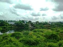
Athani as seen from Savandapur with Bhavani River separating the regions | |
 Athani  Athani | |
| Coordinates: 11°31′17″N 77°30′39″E / 11.52139°N 77.51083°ECoordinates: 11°31′17″N 77°30′39″E / 11.52139°N 77.51083°E | |
| Country | India |
| State | Tamil Nadu |
| District | Erode |
| Population (2001) | |
| • Total | 8,453 |
| Area code(s) | 04256 |
| Vehicle registration | TN 36 |
Athani is a panchayat town located about 12 km from Gobichettipalayam in Anthiyur taluk of Erode district in the state of Tamil Nadu, India.
Demographics
As of 2001 India census,[1] Athani had a population of 8453. Males constitute 51% of the population and females 49%. Athani has an average literacy rate of 53%, lower than the national average of 59.5%; with 59% of the males and 41% of females literate. 10% of the population is under 6 years of age.
Athani is a laid back town and lies on the banks of the Bhavani river which meanders between Savandapur on one side and Athani on the other side. Due to its proximity to the river, People are mainly occupied with agriculture. Paddy, Sugarcane and turmeric are the regular cultivation crops. A lot of films have been shot here. Athani has a lot of temples and the traditional festivals are conducted with usual pomp and fare. The famous Pariyur Kondathu Kaliamman Temple is 10 Kilometres. The Karungaradu Murugan Temple and Odaimedu Easwaran Koil are some of the other notable temples around this area.
References
- ↑ "Census of India 2001: Data from the 2001 Census, including cities, villages and towns (Provisional)". Census Commission of India. Archived from the original on 2004-06-16. Retrieved 2008-11-01.