Atrai River
| Atrai River | |
| Atreyee River | |
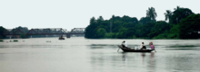
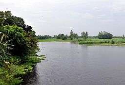 View of the Atrai River | |
| Countries | India, Bangladesh |
|---|---|
| State | West Bengal |
| Landmark | Balurghat Town |
| Source | Jorapani river |
| - location | near Baikanthapur forest, Ward No 40, Siliguri, West Bengal, India |
| Mouth | Chalan Beel |
| Length | 390 km (242 mi) |
- This article refers to Atreyee or Atrai river. For other articles regarding Atreyee see Atreyee (disambiguation).
- For the video game company, see Atari
Atrai River (also spelt as Atreyee) (Bengali: আত্রাই/আত্রেই নদী) flows in West Bengal and northern parts of Bangladesh.
In ancient times the river was called Atrei and finds a mention in the Mahabharata. It is linked with Jorapani river, Fuleswari river, and Karatoya River. It originates in Siliguri ward no 40, near baikanthapur forest West Bengal and then after flowing through Dinajpur District of Bangladesh, it enters India again.[1] It passes through Kumarganj and Balurghat community development blocks in Dakshin Dinajpur district. [2] The river then renters Bangladesh. It splits into two rivers—the Gabura and the Kankra in Dinajpur district. It crosses the Barind Tract and flows into Chalan Beel.[1] The river serves as a perennial source of fishing, even though it is often the cause of flooding in many areas during monsoons.[3]
Total length of this river is approximately 240 miles (390 km). The maximum depth of the river is 99 feet (30 m).
Early history
The Atrai was formerly one of the greatest rivers of north Bengal for it was the main channel by which the waters of the Teesta discharged into the Ganges. In 1787, however, the Teesta broke away from its ancient bed and cut for itself a new and capacious channel by which it found its way into the Brahmaputra. Since then the Atrai has lost its importance and has now few traces of its former greatness.
It enters the district from Rajshahi flowing through the Chalan Beel and falls into the Baral near the village of Nurnagar. Formerly, it used to pursue a course to the south and east after leaving the Chalan Beel till it fell into the Jamuna; but the middle portion of this old channel has been obliterated by the Baral and the Ichhamati, which, taking off from the Padma cut across the Atrai and overwhelmed it by copious deposit of silt.
The southern portion of the river in this district can still be traced from its junction with the Ichhamati at Boalmari; it then flows through Dulai and Bera thana and falls into the Padma near Ratanganj. This river presents one of the most striking instances of riverine changes in the district of Pabna.
References
- 1 2 Mesbah-us-Saleheen (2012). "Atrai River". In Sirajul Islam and Ahmed A. Jamal. Banglapedia: National Encyclopedia of Bangladesh (Second ed.). Asiatic Society of Bangladesh.
- ↑ "Dakshin Dinajpur". River. District administration. Retrieved 2009-08-22.
- ↑ "Flood Prevention plan for river Atreyee". District administration. Retrieved 2009-08-19.
Coordinates: 25°14′48″N 88°46′32″E / 25.24667°N 88.77556°E