Kangsabati River
| Kangsabati River (Kasai) | |
| Cossye | |
_river.jpg) Kangsabati River near Midnapore town | |
| Country | India |
|---|---|
| State | West Bengal |
| Tributaries | |
| - right | Kumari River |
| Cities | Purulia, Bankura, Midnapore |
| Source | |
| - location | Murguma, Purulia district, Chota Nagpur Plateau, West Bengal |
| Length | 465.23 km (289 mi) |
 | |
- For river in Africa see Kasai River
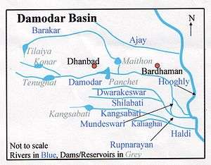
Kangsabati River (Pron:/ˌkæŋsəˈbɑːtɪ/) (also variously known as the Kasai and Cossye) rises from the Chota Nagpur plateau in the state of West Bengal, India and passes through the districts of Purulia, Bankura and Paschim Medinipur in West Bengal before draining in the Bay of Bengal.
Course
After rising at Murguma near Jhalda in the Chota Nagpur plateau in Purulia district, it passes by Purulia, Khatra and Ranibandh in Bankura district, and then enters Paschim Medinipur in the Binpur area. It is joined by Bhairabbanki. At Keshpur the river splits into two. The northern branch flows through the Daspur area as Palarpai and joins the Rupnarayan River. The other branch flows in a south-easterly direction and on joining the Kaliaghai River forms the Haldi River, which flows into the Bay of Bengal at Haldia.[1]
Kangshabati is created from the confluence of two smaller river streams namely Saharjhor and Girgiri and takes the name of Kangshabati near Tigra village of C. D. Block Jhalda II in district Puruliya.
Purulia, Mukutmanipur, Binpur, Midnapore, and Kharagpur are towns on or near the banks of this river.
Kangsabati Project
The Kangsabati Project was started in 1956 as part of the Indian Second Five-year Plan to provide water to 3,484.77 square kilometres (1,345.48 sq mi) of land in the districts of Paschim Medinipur, Purba Medinipur, Bankura, Purulia District and Hooghly.[2] It involves irrigation land using water from the Kangsabati River, as well as the Shilabati and the Bhoirobbanki rivers.
As part of the project, a 38-metre (125 ft) high and 10,098-metre (33,130 ft) long dam, Mukutmanipur Dam, was constructed at the border of Purulia and West Midnapore. An anicut dam built on the Kangsabati River near Midnapore in 1872 was also added to the operations of the project.[3]
References
- ↑ Bandopadhyay, Dilip Kumar, Bharater Nodi, p.68, Bharati Book Stall, 93 Mahatma Gandhi Road, Kolkata 700 997
- ↑ Irrigation & Waterways Dept - Irrigation Sector - Major Irrigation Projects - Kangasbati
- ↑ Bharatkosh
See also
Coordinates: 22°55′20″N 86°46′47″E / 22.922350°N 86.779633°E