Aure, Sykkylven
| Aure Sykkylven | |
|---|---|
| Village | |
 | |
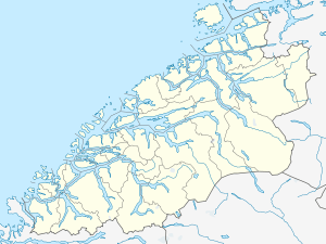 Aure  Aure Location in Møre og Romsdal | |
| Coordinates: 62°23′28″N 06°34′48″E / 62.39111°N 6.58000°ECoordinates: 62°23′28″N 06°34′48″E / 62.39111°N 6.58000°E | |
| Country | Norway |
| Region | Western Norway |
| County | Møre og Romsdal |
| District | Sunnmøre |
| Municipality | Sykkylven |
| Area[1] | |
| • Total | 3.32 km2 (1.28 sq mi) |
| Elevation[2] | 20 m (70 ft) |
| Population (2013)[1] | |
| • Total | 4,258 |
| • Density | 1,283/km2 (3,320/sq mi) |
| Time zone | CET (UTC+01:00) |
| • Summer (DST) | CEST (UTC+02:00) |
| Post Code | 6230 Sykkylven |
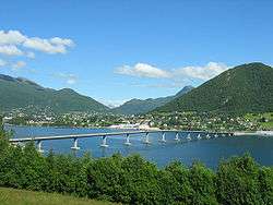
Aure (also called Sykkylven) is the administrative center of Sykkylven Municipality in Møre og Romsdal county, Norway. The village is located along the eastern shore of the Sykkylvsfjorden. It is about 7 kilometres (4.3 mi) north of Straumgjerde and 3 kilometres (1.9 mi) east of Ikornnes (via the Sykkylven Bridge).
The 3.32-square-kilometre (820-acre) village has a population (2013) of 4,258; giving the village a population density of 1,283 inhabitants per square kilometre (3,320/sq mi), making it the largest urban area in the municipality.[1] Sykkylven Church is located in this village. The village is home to various types of industry, especially furniture building, woodworking, and mechanical engineering.[3]
References
- 1 2 3 Statistisk sentralbyrå (1 January 2013). "Urban settlements. Population and area, by municipality.".
- ↑ "Aure" (in Norwegian). yr.no. Retrieved 2010-10-06.
- ↑ Store norske leksikon. "Sykkylven – tettstedet" (in Norwegian). Retrieved 2013-07-01.
This article is issued from Wikipedia - version of the 8/1/2016. The text is available under the Creative Commons Attribution/Share Alike but additional terms may apply for the media files.