Avery, Idaho
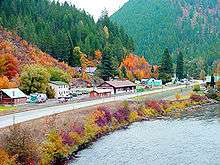
Avery is a small unincorporated community nestled in the St. Joe River Valley in Shoshone County, Idaho, United States. Avery is located in the middle of the St. Joe District of the Idaho Panhandle National Forest. Avery is a popular tourist attraction in northern Idaho for its beautiful wilderness and outdoor recreation.
Geography
- Latitude 47.25 (ºN)
- Longitude -115.80 (ºW)
- Elevation: 2486 feet (757 m) above sea level
Climate
This climatic region is typified by large seasonal temperature differences, with warm to hot (and often humid) summers and cold (sometimes severely cold) winters. According to the Köppen Climate Classification system, Avery has a humid continental climate, abbreviated "Dfb" on climate maps.[1]
Demographics
Avery has a population of 25 permanent residents.[2] The temporary population is higher in the summer though due to seasonal workers for the United States Forest Service and the many summer homes in Avery and along the St. Joe River.
History
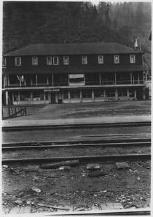
The town was from the years 1909 to 1980 a division point on the Milwaukee Road railroad's "Pacific Extension". It was also once the western terminus for the easternmost of two electrified mountain sections on the route. The other ran from Othello, Washington, through the Cascade Mountains to the Puget Sound. Electric operations ran from 1914–74 on this section to Harlowton, Montana. Trains stopped at the Avery Depot, now listed on the National Register of Historic Places. Here, steam or diesel locomotives were changed or hooked up to electric locomotives.
During the Great Fire of 1910, a 28-man firefighting team died near Setzer Creek outside of Avery.[3] The U.S. Army's 25th Infantry Regiment (known as the Buffalo Soldiers) helped build a back fire that saved Avery.
Recreation
Common activities include nature photography, camping, hunting, ATV riding, snowmobiling, hiking, horseback riding, mountain biking, fishing, and rafting.
Attractions
The main attraction in Avery is the Fish Pond. All year long, tourists can purchase a handful of fish food for twenty-five cents and watch as the massive rainbow trout leap out of the water to get a bite to eat.[4]
References
- ↑ Climate Summary for Avery, Idaho
- ↑ Robinson, Jessica (September 9, 2013). "Avery, Idaho Struggles To Keep Its Remaining 25 Residents And Its Spot On The Map". Boise State Public Radio. Retrieved February 17, 2014.
- ↑ Pyne, Stephen J. (2008). Year of the Fires: The Story of the Great Fires of 1910. Missoula, Montana: Mountain Press Publishing Company. pp. 155–157, 175–176. ISBN 978-0-87842-544-0.
- ↑ Kaminsky, Stephen (May 20, 2003). "Get hooked in Avery". The Argonaut. University of Idaho. Archived from the original on February 14, 2006. Retrieved February 17, 2014.
External links
- MSRmaps.com - USGS topo map and aerial photo
Municipalities and communities of Shoshone County, Idaho, United States | ||
|---|---|---|
| Cities | ||
| Unincorporated communities | ||
| Footnotes | ‡This populated place also has portions in an adjacent county or counties | |
Coordinates: 47°15′00″N 115°48′07″W / 47.25000°N 115.80194°W