Wallace, Idaho
| Wallace, Idaho | |
|---|---|
| City | |
|
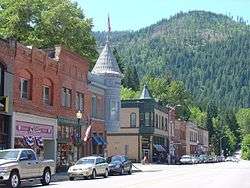
Buildings in Wallace's historic district | |
| Nickname(s): Silver Capital of the World | |
 Location of Wallace, Idaho | |
 Wallace, Idaho Location in the United States | |
| Coordinates: 47°28′23″N 115°55′30″W / 47.47306°N 115.92500°WCoordinates: 47°28′23″N 115°55′30″W / 47.47306°N 115.92500°W | |
| Country | United States |
| State | Idaho |
| County | Shoshone |
| Area[1] | |
| • Total | 0.84 sq mi (2.18 km2) |
| • Land | 0.84 sq mi (2.18 km2) |
| • Water | 0 sq mi (0 km2) |
| Elevation | 2,730 ft (832 m) |
| Population (2010)[2] | |
| • Total | 784 |
| • Estimate (2012[3]) | 780 |
| • Density | 933.3/sq mi (360.3/km2) |
| Time zone | Pacific (PST) (UTC-8) |
| • Summer (DST) | PDT (UTC-7) |
| ZIP codes | 83873-83874 |
| Area code(s) | 208 |
| FIPS code | 16-84790 |
| GNIS feature ID | 0392796 |
| Website | http://www.wallace-id.com |
Wallace is a historic city in the Panhandle region of the U.S. state of Idaho and the county seat of Shoshone County[4] in the Silver Valley mining district. Wallace sits alongside the South Fork Coeur d'Alene River (and Interstate 90) and the town's population was 784 at the 2010 census.
Wallace is the principal town of the Coeur d'Alene silver-mining district, which produced more silver than any other mining district in the United States. Burke-Canyon Road runs through historic mining communities – many of them now deserted – north and eastward toward the Montana state line. East of Wallace, the Route of the Hiawatha (rails-to-trails) and the Lookout Pass ski area are popular with locals and tourists.
The elevation is 2,728 feet (831 m) above sea level.
History

The city was named for Colonel W.R. Wallace, a landowner.[5][6] In 1890, Shoshone County was the most populated county in the new state of Idaho, and Wallace was its largest city and the third largest in the state, with 2000 residents.
The area periodically experienced open warfare between miners and mine owners. Hard rock miners in Shoshone County protested wage cuts with a strike in 1892. After several lost their lives in a shooting war provoked by discovery of a company spy, the U.S. Army forced an end to the strike. Hostilities erupted once again in 1899 when, in response to the company firing seventeen men for joining the union, the miners dynamited the Bunker Hill & Sullivan mill. Again, lives were lost, and the Army intervened.
One third of the town of Wallace was destroyed by the Great Fire of 1910, which burned about 3,000,000 acres (12,141 km2; 4,688 sq mi) in Washington, Idaho, and Montana.[7]
In 1979, several blocks of downtown Wallace were listed on the National Register of Historic Places as a historic district, the Wallace Historic District.[8][9][10]
Geography
Wallace is located at 47°28′23″N 115°55′30″W / 47.47306°N 115.92500°W (47.472923, −115.924935).[11]
According to the United States Census Bureau, the city has a total area of 0.84 square miles (2.18 km2), all of it land.[1]
Wallace has a continental Mediterranean climate (Köppen Dsb) with warm summers and cold, snowy winters. Winters are relatively moderate for an inland location so far north, although heavy rainfall often occurs when mild Pacific air penetrates inland, as in January 1974 when 14.56 inches (369.8 mm) of precipitation occurred including 3.07 inches (78.0 mm) on the 16th. July 1973 to June 1974 was also the wettest “rain year”, receiving 56.27 inches or 1,429.3 millimetres, whilst the driest rain year from July 2000 to June 2001 saw only 21.96 inches or 557.8 millimetres. The most snowfall has been 91.0 inches (2.31 m) in January 1969; July 1968 to June 1969 also saw the maximum annual snowfall at 167.0 inches or 4.24 metres.
When cold air comes in from Canada, temperatures can become severe, with the record low being −31 °F or −35 °C on December 30, 1968. The coldest month since records began in 1941 has been January 1949 with an average of 10.5 °F or −11.9 °C; the hottest has been July 2007 with a daily mean of 73.2 °F or 22.9 °C and a mean maximum of 91.1 °F or 32.8 °C.
| Climate data for Wallace Woodland Park (1971–2000) | |||||||||||||
|---|---|---|---|---|---|---|---|---|---|---|---|---|---|
| Month | Jan | Feb | Mar | Apr | May | Jun | Jul | Aug | Sep | Oct | Nov | Dec | Year |
| Record high °F (°C) | 57 (14) |
67 (19) |
77 (25) |
91 (33) |
96 (36) |
103 (39) |
102 (39) |
106 (41) |
101 (38) |
88 (31) |
70 (21) |
56 (13) |
106 (41) |
| Average high °F (°C) | 33.6 (0.9) |
38.9 (3.8) |
46.0 (7.8) |
54.7 (12.6) |
63.1 (17.3) |
70.0 (21.1) |
78.3 (25.7) |
79.3 (26.3) |
69.6 (20.9) |
57.2 (14) |
40.7 (4.8) |
33.3 (0.7) |
55.4 (13) |
| Average low °F (°C) | 19.8 (−6.8) |
22.6 (−5.2) |
27.1 (−2.7) |
32.7 (0.4) |
39.0 (3.9) |
45.2 (7.3) |
48.9 (9.4) |
48.4 (9.1) |
40.7 (4.8) |
33.2 (0.7) |
27.5 (−2.5) |
20.9 (−6.2) |
33.8 (1) |
| Record low °F (°C) | −27 (−33) |
−21 (−29) |
−16 (−27) |
15 (−9) |
18 (−8) |
28 (−2) |
33 (1) |
30 (−1) |
23 (−5) |
7 (−14) |
−14 (−26) |
−31 (−35) |
−31 (−35) |
| Average precipitation inches (mm) | 5.12 (130) |
4.10 (104.1) |
3.68 (93.5) |
2.91 (73.9) |
3.01 (76.5) |
2.61 (66.3) |
1.41 (35.8) |
1.37 (34.8) |
1.75 (44.4) |
2.71 (68.8) |
5.30 (134.6) |
5.25 (133.4) |
39.22 (996.1) |
| Average snowfall inches (cm) | 20.4 (51.8) |
14.7 (37.3) |
9.1 (23.1) |
2.4 (6.1) |
0.2 (0.5) |
0.0 (0) |
0.0 (0) |
0.0 (0) |
trace | 0.7 (1.8) |
10.6 (26.9) |
20.7 (52.6) |
78.8 (200.2) |
| Average precipitation days (≥ 0.01 inch) | 17.2 | 14.9 | 16.4 | 14.4 | 14.8 | 12.3 | 7.8 | 7.0 | 8.4 | 10.8 | 17.7 | 17.7 | 159.4 |
| Average snowy days (≥ 0.1 inch) | 9.1 | 6.9 | 5.7 | 1.8 | 0.2 | 0.0 | 0.0 | 0.0 | 0.0 | 0.5 | 5.4 | 9.4 | 39 |
| Source #1: NOAA (normals, 1971–2000)[12] | |||||||||||||
| Source #2: NOWData (extremes for June and October)[13] | |||||||||||||
Demographics
| Historical population | |||
|---|---|---|---|
| Census | Pop. | %± | |
| 1890 | 878 | — | |
| 1900 | 2,265 | 158.0% | |
| 1910 | 3,000 | 32.5% | |
| 1920 | 2,816 | −6.1% | |
| 1930 | 3,634 | 29.0% | |
| 1940 | 3,839 | 5.6% | |
| 1950 | 3,140 | −18.2% | |
| 1960 | 2,412 | −23.2% | |
| 1970 | 2,206 | −8.5% | |
| 1980 | 1,736 | −21.3% | |
| 1990 | 1,010 | −41.8% | |
| 2000 | 960 | −5.0% | |
| 2010 | 784 | −18.3% | |
| Est. 2015 | 761 | [14] | −2.9% |
2010 census
As of the census[2] of 2010, there were 784 people, 364 households, and 190 families residing in the city. The population density was 933.3 inhabitants per square mile (360.3/km2). There were 535 housing units at an average density of 636.9 per square mile (245.9/km2). The racial makeup of the city was 95.9% White, 0.1% African American, 1.0% Native American, 0.3% Asian, 0.4% from other races, and 2.3% from two or more races. Hispanic or Latino of any race were 2.3% of the population.
There were 364 households of which 20.1% had children under the age of 18 living with them, 39.3% were married couples living together, 8.8% had a female householder with no husband present, 4.1% had a male householder with no wife present, and 47.8% were non-families. 42.3% of all households were made up of individuals and 16.2% had someone living alone who was 65 years of age or older. The average household size was 1.99 and the average family size was 2.66.
The median age in the city was 47.5 years. 16.1% of residents were under the age of 18; 8.7% were between the ages of 18 and 24; 21.4% were from 25 to 44; 34.1% were from 45 to 64; and 19.5% were 65 years of age or older. The gender makeup of the city was 52.9% male and 47.1% female.
2000 census
As of the census[16] of 2000, there were 960 people, 427 households, and 237 families residing in the city. The population density was 1,104.4 people per square mile (426.0/km²). There were 587 housing units at an average density of 675.3 per square mile (260.5/km²). The racial makeup of the city was 94.90% White, 2.50% Native American, 0.10% Asian, 0.62% from other races, and 1.88% from two or more races. Hispanic or Latino of any race were 2.19% of the population.
There were 427 households out of which 25.5% had children under the age of 18 living with them, 41.0% were married couples living together, 8.4% had a female householder with no husband present, and 44.3% were non-families. 39.3% of all households were made up of individuals and 15.7% had someone living alone who was 65 years of age or older. The average household size was 2.14 and the average family size was 2.85.
In the city the population was spread out with 22.9% under the age of 18, 6.8% from 18 to 24, 28.4% from 25 to 44, 25.8% from 45 to 64, and 16.0% who were 65 years of age or older. The median age was 41 years. For every 100 females there were 99.2 males. For every 100 females age 18 and over, there were 104.4 males.
The median income for a household in the city was $22,065, and the median income for a family was $33,472. Males had a median income of $25,288 versus $16,429 for females. The per capita income for the city was $14,699. About 12.8% of families and 20.1% of the population were below the poverty line, including 20.4% of those under age 18 and 10.5% of those age 65 or over.

Transportation
Wallace is accessible via Interstate 90, State Highway 4, and a local airport. The nearest airport is Shoshone County Airport (S83), in the nearby city of Smelterville.
In its prime, two railroads served Wallace. The Oregon-Washington Railway & Navigation Co. (Union Pacific) reached Wallace from the west, offering passenger service to Spokane and Portland until about 1958, and freight service to Spokane as late as 1992. The Northern Pacific Railway approached Wallace from the east with its branch over Lookout Pass to the NP mainline at St. Regis. The former NP depot still stands (although relocated 200 ft from its original site to avoid demolition during freeway construction) and is listed on the National Register of Historic Places.[17] It currently functions as a local railroad museum. The former NP line was abandoned and removed between St. Regis and Mullan in 1980. Union Pacific continued operating the Wallace-Mullan segment of the NP line until abandoning the entire Plummer-Mullan route in 1992. After abandonment, this segment of former UP and NP lines was developed into the Trail of the Coeur d'Alenes. This trail runs from east of Mullan, through Wallace, to the Washington-Idaho state line west of Plummer.[18]
Several miles to the south, the Chicago, Milwaukee, St. Paul and Pacific Railroad, commonly called the Milwaukee Road, ran transcontinental passenger trains between Chicago and Seattle from 1911 to 1961, with freight trains operating on this route as late as 1980. After the Milwaukee Road discontinued and abandoned the route, much of the Milwaukee Road route became a rails-to-trail known as the "Route of the Hiawatha Trail" .[19] Currently, the trail is open from Taft, Montana (near the top of Lookout Pass), west to Avery, Idaho. At its nearest point, this trail is at least 15 miles distant from Wallace. However, Wallace is its nearest large community, and as such advertises itself as the primary jumping off point for trail users.
Interstate 90
Interstate 90 passes through Wallace on an elevated freeway viaduct built in 1991. Until the freeway opened, I-90 traffic used a surface highway previously designated U.S. Route 10. The highway used the main city streets through downtown. Wallace had the last traffic light on a coast-to-coast Interstate highway, a fact that is displayed on signage in downtown Wallace proclaiming it to be "The Last Stoplight". On September 15, 1991, the Idaho Department of Transportation moved I-90 to a freeway viaduct above the north side of the town. Prior to this the interstate turned into arterial streets on the western outskirts of town and followed the main road through town before becoming a highway again on Wallace's east side. The section of US 10 through Wallace is now designated Interstate 90 Business.
The Federal Highway Administration (FHWA) originally planned to build I-90 as an at-grade freeway. This plan would have demolished most of downtown Wallace. In the 1970s, city leaders undertook an effort to list downtown on the National Register of Historic Places with the result that now every building in downtown Wallace is on the National Register of Historic Places. The FHWA had to redesign I-90 to bypass downtown because federal law protects historic places from negative effects of highway construction.[8][9][10] The elevated viaduct is the FHWA's solution to this problem.
In popular culture
The 1997 film Dante's Peak was shot on location in Wallace, which was portrayed as the fictional town "Dante's Peak" in Washington state, with a large hill just southeast of the town digitally altered to look like a volcano. Many scenes involving townspeople, including the initial award ceremony, the pioneer days festival, and the gymnasium scene were shot using the actual citizens of Wallace as extras. Many of the disaster evacuation scenes that did not involve stunts and other dangerous moments also featured citizens of Wallace; dangerous stunts were filmed using Hollywood extras.[20][21][22]
On September 25, 2004, Mayor Ron Garitone proclaimed Wallace to be the center of the Universe. Specifically, a sewer access cover was declared to be the precise location of the center of the Universe. A specially made manhole cover was made to mark the spot. It bears the words "Center of the Universe. Wallace, Idaho." This prompted British comedian and writer Danny Wallace to visit Wallace. He wrote about his visit in the book Danny Wallace and the Centre of the Universe, published in 2006. The event is celebrated on the third Saturday of September.[23]
Notable people
- Michael Norell (born 1937), actor and screenwriter
- Ed Pulaski (1868–1931), forest ranger noted for his heroism in the Great Fire
- Mike Riley (born 1953), head football coach of the Nebraska Cornhuskers
- Lana Turner (1921-1995), actress, was born in Wallace and spent her early childhood there[24][25]
References
- 1 2 "US Gazetteer files 2010". United States Census Bureau. Retrieved 2012-12-18.
- 1 2 "American FactFinder". United States Census Bureau. Retrieved 2012-12-18.
- ↑ "Population Estimates". United States Census Bureau. Retrieved 2013-06-03.
- ↑ "Find a County". National Association of Counties. Retrieved 2011-06-07.
- ↑ "Profile for Wallace, Idaho". ePodunk. Retrieved 2010-05-28.
- ↑ "Folklore Refuted by Early Settler". The Spokesman-Review. 18 October 1965. p. 5. Retrieved 23 April 2015.
- ↑ Pyne, Stephen J. (2008). Year of the Fires: The Story of the Great Fires of 1910. Missoula, Montana: Mountain Press Publishing Company. ISBN 978-0-87842-544-0.
- 1 2 National Park Service (2009-03-13). "National Register Information System". National Register of Historic Places. National Park Service.
- 1 2 "Wallace Historic District NRHP" (PDF). National Register of Historic Places. National Park Service.
- 1 2 "Wallace Historic District boundary increase" (PDF). National Register of Historic Places. National Park Service.
- ↑ "US Gazetteer files: 2010, 2000, and 1990". United States Census Bureau. 2011-02-12. Retrieved 2011-04-23.
- ↑ "Climatography of the United States NO.81" (PDF). National Oceanic and Atmospheric Administration. Retrieved January 13, 2011.
- ↑ "National Weather Service Forecast Office: Spokane, WA". National Weather Service. Retrieved November 2, 2016.
- ↑ "Annual Estimates of the Resident Population for Incorporated Places: April 1, 2010 to July 1, 2015". Retrieved July 2, 2016.
- ↑ "Census of Population and Housing". Census.gov. Retrieved June 4, 2015.
- ↑ "American FactFinder". United States Census Bureau. Retrieved 2008-01-31.
- ↑ "Northern Pacific Railway Depot" (PDF). National Register of Historic Places. National Park Service.
- ↑ Google Maps (GPS: 47.472395,-115.9153)
- ↑ "Route of the Hiawatha Bike Trail". Website. lookout Pass Ski Area.
- ↑ "That's A Wrap After A Summer Of Filming In Wallace, Idaho, 'Dante's Peak' Heads Back To L.A.".
- ↑ "Wallace's Peek Residents, Extras View 'Dante's Peak' At Champagne Gala And Premiere".
- ↑ "Eugene Register-Guard - Google News Archive Search".
- ↑ "The Center of the Universe is in Historic Wallace Idaho".
- ↑ "Lana Turner lived in Historic Wallace". Wallace ID. Retrieved 2015-04-10.
- ↑ Grever, Brendley (1941-05-15). "Lana Turner, Born in Wallace, Idaho, Twenty Years Ago, Now a Star". Spokane Daily Chronicle. p. 16.
External links
| Wikimedia Commons has media related to Wallace, Idaho. |
Municipalities and communities of Shoshone County, Idaho, United States | ||
|---|---|---|
| Cities | ||
| Unincorporated communities | ||
| Footnotes | ‡This populated place also has portions in an adjacent county or counties | |