Bécancour, Quebec
| Bécancour | ||
|---|---|---|
| City | ||
|
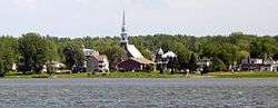
Sainte-Angèle-de-Laval | ||
| ||
|
Motto: Vivre et grandir ("To live and to grow") | ||
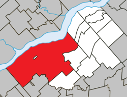 Location within Bécancour RCM. | ||
 Bécancour Location in southern Quebec. | ||
| Coordinates: 46°20′N 72°26′W / 46.333°N 72.433°WCoordinates: 46°20′N 72°26′W / 46.333°N 72.433°W[1] | ||
| Country |
| |
| Province |
| |
| Region | Centre-du-Québec | |
| RCM | Bécancour | |
| Constituted | October 17, 1965 | |
| Government[2] | ||
| • Mayor | Jean-Guy Dubois | |
| • Federal riding | Bécancour—Nicolet—Saurel | |
| • Prov. riding | Nicolet-Bécancour | |
| Area[2][3] | ||
| • Total | 494.60 km2 (190.97 sq mi) | |
| • Land | 440.74 km2 (170.17 sq mi) | |
| Elevation | 148 m (486 ft) | |
| Population (2011)[3] | ||
| • Total | 12,438 | |
| • Density | 28.2/km2 (73/sq mi) | |
| • Pop 2006-2011 |
| |
| • Dwellings | 5,667 | |
| Time zone | EST (UTC−5) | |
| • Summer (DST) | EDT (UTC−4) | |
| Postal code(s) | G9H | |
| Area code(s) | 819 | |
| Highways |
| |
| Website |
www | |

Bécancour (French pronunciation: [bekɑ̃kuʁ]) is a city in the Centre-du-Québec region of Québec, Canada; it is the seat of the Bécancour Regional County Municipality. It is located on the south shore of the Saint Lawrence River at the confluence of the Bécancour River, opposite Trois-Rivières.
Wôlinak, an Abenaki Indian reserve, is an enclave within the town of Bécancour. They arrived from Norridgewock, Maine (formerly Acadia) in the aftermath of Father Rale's War.
There was a small migration of Acadians to the village (1759), after the British began the Expulsion of the Acadians from the Maritimes. Specifically, the Acadians migrated from present-day New Brunswick to avoid being killed or captured in the St. John River Campaign.
Description
The town of Bécancour was created October 17, 1965, from an amalgamation of eleven municipalities. Bécancour was one of the province of Quebec's first amalgamated cities.[4] At the time, Bécancour was the largest city in Quebec in terms of land area (as of 2003, the title belongs to La Tuque, Quebec).
Bécancour is now divided into six secteurs (lit. "sectors"): Bécancour, Saint-Grégoire, Gentilly, Précieux-Sang, Sainte-Angèle-de-Laval, and Sainte-Gertrude. Bécancour, Saint-Grégoire and Gentilly, each located near the shore of the Saint Lawrence River, can be considered the main urban centres. Autoroute 55 intersects Autoroute 30 and Route 132 at Saint-Grégoire.
Bécancour is part of the Trois-Rivières metropolitan area; many residents work in Trois-Rivières and commute across the Laviolette Bridge daily. The economy of Bécancour, once mainly agricultural, shifted towards heavy industry and manufacturing in the 1970s and 1980s. An industrial park was built in the area, attracting producers of aluminum, magnesium, refractory metals, and petroleum products; machine shops; and many related services, such as excavators and sales of industrial parts. A nuclear power plant, Gentilly Nuclear Generating Station, was commissioned in 1983 in the Gentilly sector; it was decommissioned in 2012.[5]
Despite its proximity to Trois-Rivières, Bécancour has a vibrant culture and identity of its own. The city hosts a hot air balloon festival,[6] a weekly public marketplace, a biodiversity museum and interpretation centre, and a maritime pumpkin race.[7]
History
Constituent municipalities of Bécancour included:[4]
- La Nativité de Notre-Dame-de-Bécancour (1722)
- Saint-Édouard-de-Gentilly (1784)
- Saint-Grégoire-le-Grand (1802)
- Sainte-Gertrude (1845)
- Sainte-Angèle-de-Laval (1868)
- Très-Précieux-Sang-de-Notre-Seigneur (1903)
And the villages of:
- Larochelle (1863)
- Gentilly (1900)
- Villers (1901)
- Bécancour et Laval (1909)
Demographics
According to the Canada 2011 Census:
- Population: 12,438
- % Change (2006–2011): +13.3
- Dwellings: 5,667
- Area (km2): 440.74
- Density (persons per km2): 28.2
Communities
Notable Bécancour residents
- Nicolas Perrot (1644–1717), explorer, diplomat, and fur trader.
- Blessed Louis Zephyrinus Moreau, Canadian Roman Catholic priest and fourth Bishop of Saint-Hyacinthe[8]
Sister city
Emblems and symbols
 |
Bird: Ruby-throated hummingbird 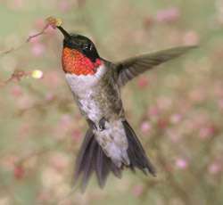 |
Slogan: De nature énergique |
See also
References
- ↑ Reference number 4505 of the Commission de toponymie du Québec (French)
- 1 2 Geographic code 38010 in the official Répertoire des municipalités (French)
- 1 2 "(Code 2438010) Census Profile". 2011 census. Statistics Canada. 2012.
- 1 2 Becancour.net
- ↑ http://nuclearsafety.gc.ca/eng/resources/my-community/becancour-trois-rivieres/index.cfm
- ↑
- ↑
- ↑ "Bishop Bl. Louis-Zéphirin Moreau". Catholic-Hierarchy.org. David M. Cheney. Retrieved 21 January 2015.
External links
| Wikimedia Commons has media related to Bécancour (city). |
 |
Trois-Rivières / Champlain Saint Lawrence River |
Saint-Pierre-les-Becquets Sainte-Cécile-de-Lévrard |
| |
| Nicolet Grand-Saint-Esprit |
|
Sainte-Sophie-de-Lévrard Sainte-Marie-de-Blandford | ||
| ||||
| | ||||
| Saint-Célestin (municipality) Saint-Célestin (village) |
Saint-Sylvère |
| Cities | |
|---|---|
| Municipalities | |
| Parishes | |
| |