Bacchus Marsh
| Bacchus Marsh Victoria | |||||||||||||
|---|---|---|---|---|---|---|---|---|---|---|---|---|---|
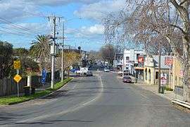 Main St, Bacchus Marsh | |||||||||||||
 Bacchus Marsh | |||||||||||||
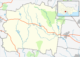
| Coordinates | 37°40′30″S 144°26′20″E / 37.67500°S 144.43889°ECoordinates: 37°40′30″S 144°26′20″E / 37.67500°S 144.43889°E | ||||||||||||
| Population | |||||||||||||
| • Density | 1,146/km2 (2,967/sq mi) | ||||||||||||
| Postcode(s) | 3340 | ||||||||||||
| Elevation | 118 m (387 ft) | ||||||||||||
| Area | 17.4 km2 (6.7 sq mi) | ||||||||||||
| Location | |||||||||||||
| LGA(s) | Shire of Moorabool | ||||||||||||
| State electorate(s) | Melton | ||||||||||||
| Federal Division(s) | Ballarat | ||||||||||||
| |||||||||||||
Bacchus Marsh is a rural centre and regional locality in Victoria, Australia located approximately 65 kilometres (40 mi) north west of the state capital Melbourne and 15 kilometres (9 mi) west of Melton at a near equidistance to the major cities of Melbourne, Ballarat and Geelong. The estimated population of Bacchus Marsh urban area was 19,934[1] at June 2015. The State Suburb by the same name is home to 5,760[2] people and contains the central business district. Bacchus Marsh is the largest rural area in the local government area of Shire of Moorabool.
Traditionally a market garden area, producing a large amount of the region's fruits and vegetables in recent decades it has transformed into the main commuter town on the Melbourne-Ballarat corridor with its affordable starter homes proving popular.[3][4]
It was named after one of its original inhabitants, Captain William Henry Bacchus, who saw the great value of this locality as it was situated on two rivers — the Lerderderg and Werribee.
History
Aboriginal
It is believed that the tribe occupying the area at the time of white settlement were the Kurung. Bacchus Marsh was a meeting ground for anywhere between 150 and 400 Aboriginals even after white settlement, and corroborees were held quite regularly. While there do not appear to be any records of open hostilities between whites and indigenous people, by 1863 there were a total of only 33 Aboriginal people left in the Bacchus Marsh district, and apart from a handful of recollections of the original inhabitants preserved by pioneer settlers, sadly little remains apart from present-day locality names, mainly of watercourses: Coimadai, Djerriwarrh, Korkuperrimul, Lerderderg, Merrimu, Myrniong, Werribee.[5][6]
European settlement
One of the first white men to reach the Bacchus Marsh valley was pastoralist Kenneth Scobie Clarke (c. 1806–79), a native of Sutherland in Scotland. Clarke was a manager for the Great Lake Company of Van Diemen’s Land and arrived in the Port Phillip District from George Town on 25 March 1836. Captain Bacchus credited Clarke as being the first man to shear sheep in Victoria, although the Hentys had arrived in Portland with their sheep some two years earlier.
On 29 November 1836, Clarke headed west from Port Phillip with a large flock of sheep, arriving in the Bacchus Marsh district a few days later. He built a hut on the west bank of the Lerderderg River near Darley, and lived there until early 1838. According to pastoralist George Russell, Clarke had acted on information obtained from Mr Aitken, an Edinburgh man, who was most put out when he discovered that Clarke had beaten him to the Pentland Hills run.[7]
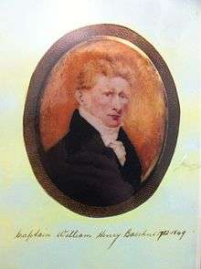
In 1838, Englishman Captain William Henry Bacchus (1782–1849) and his son William Henry Bacchus junior (1820–87) also brought sheep from Tasmania and came to the district which now bears their name. On their arrival, Clarke made an arrangement with them and ceded his run, moving to the nearby hills known as the Pentlands. The then very swampy valley was not really suitable for sheep, as they were prone to footrot. Clarke stayed in the district until 1840 or 1841, and later went to New Zealand, where he died in 1879.
As all land within 3 miles (5 km) of a squatter’s hut was considered to belong to him, Bacchus and his son immediately set about consolidating their land holdings. By 1839–40, they had a homestead and four outstations on the Lardedark run, which in 1845 covered about 22 square miles (57 km2) and carried nearly 3,000 sheep. Between 1845–47 Captain Bacchus built the Manor House, a two-storey Georgian brick building that still stands in the township today. Captain Bacchus died in 1849 and was buried in what later became the grounds of Holy Trinity Anglican Church, Gisborne Road. By 1851, Henry Bacchus junior had sold his holdings in Bacchus Marsh and moved to Peerewur (or Perewerrh) run near Ballarat.[6][8][9]
Local Government
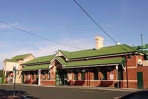
The township was originally known as Ballan, a Post Office opening under that name around July 1844 (Bacchus Marsh from July 1, 1850).[10] The Bacchus Marsh Road District Board was proclaimed on 30 September 1856, with one of its first tasks being to construct a gravel road through the town, as at that time the road was barely passable in winter. Bacchus Marsh was created a district on 14 October 1862, and the Road Board was the governing body until the Shire of Bacchus Marsh was proclaimed on 23 January 1871.[11] The railway came to Bacchus Marsh on 15 February 1887, and the through line to Ballarat was built in 1890.[8][11][12]'
In 1994 the Shire of Bacchus Marsh was amalgamated with the Shire of Ballan and parts of the Shires of Bungaree and Werribee to form the Shire of Moorabool.[13]
Bacchus Marsh and its suburbs form the largest settlement in Moorabool Shire.
From Rural to Urban
Bacchus Marsh grew rapidly from the 1990s.
Heritage listed sites
Bacchus Marsh contains a number of heritage listed sites, including:
- Bacchus Marsh Road, Bacchus Marsh Avenue of Honour[14]
- 123 Main Street, Bacchus Marsh Court House[15]
- 8 Gisborne Road and 8 Church Street, Bacchus Marsh Express Office and Printing Works[16]
- 119 Main Street, Bacchus Marsh Police Station and Old Lock-Up[17]
- 100-102 Main Street, Blacksmith's Cottage and Shop[18]
- 12 Ellerslie Court, Ellerslie[19]
- 28-32 Manor Street, Manor House[20]
- 37 Grant Street, Millbank[21]
- 6 Gisborne Road, Residence[22]
- 10 Gisborne Road, Residence[23]
In addition, a Pioneer Women's Memorial Avenue commemorates the lives of the women of the Bacchus Marsh area.[24]
Urban Structure
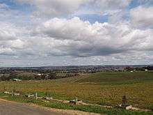
It covers a large area in the Werribee Valley with its Central Business District centred along Main Street between Bennett Street to the north, Grant Street/Gisborne Road to the west, Young/Lord Streets to the east and Waddell/Simpson Streets to the south. Bacchus Marsh Village shopping centre is its main indoor shopping mall.
Beyond central Bacchus Marsh, suburban areas such as the former towns of Darley (1861) to the north and Maddingley to the south continue to grow rapidly. Housing development has also occurred in surrounding areas including Parwan, Hopetoun Park and Merrimu.
Transport

Automobiles are the main form of transport. The Western Freeway which is the main route to both Melbourne (approximately 48 minutes) in the east and Ballarat (46 minutes) to the west. The freeway divides Bacchus Marsh and its northern suburb Darley. Two interchanges serve the urban area - the Gisborne Road full diamond and Bacchus Marsh Road half diamond. With the exception of the central business district and neighbouring areas, the majority of the urban area is laid out in a street hierarchy pattern with collector roads leading to the two major cross roads - Bacchus Marsh Road (C602) and Bacchus Marsh-Gisborne Road/Bacchus Marsh-Geelong Road (C704) which bearing the majority of vehicular traffic.
Until 2012, the entrance to the town from Melbourne was via Anthonys Cutting, a relatively steep downhill run, which is speed limited to 80 km/h. The freeway was realigned under the Victorian Transport Plan bypassing Anthony's cutting, resulting in decreased travel time to Melbourne.[25]
The Bacchus Marsh station is on the Ballarat line. V/Line provides VLocity services to Melbourne (from 38 minutes) and Ballarat (from 34 minutes).
A bus service connects the station with the town centre and other residential areas.
Bacchus Marsh Airfield (located in Parwan to the south) provides for general aviation and the area is home to a flying school and three gliding clubs.
Recreation and open space
One of its principal recreation areas is Maddingley Park, which is a favourite picnic destination for both locals and visitors. Near the south gates of the park, opposite the Bacchus Marsh railway station, is the Nieuwesteeg Heritage Rose Garden of mainly twentieth century hybrid teas.
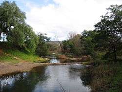
Walks along the Lerderderg River provide access to the steep, rugged and overgrown Lerderderg Gorge and the extensive Wombat State Park that surrounds it, criss-crossed by four-wheel drive tracks, extensive bushwalking amongst historic mining relics and natural bush.
Health services
The township of Bacchus Marsh is serviced by the Djerriwarrh Health Services (Bacchus Marsh Hospital) formerly, Bacchus Marsh War Memorial Hospital, and several general practice medical centres, including Bacchus Marsh Medical Centre located opposite the hospital in Turner Street and The Elms Family Medical Centre located at the Bacchus Marsh Village Shopping Centre on Main Street near the Avenue of Honour. The Elms Family Medical Centre was established in 1994 and is actively involved in the teaching and mentoring of future general practitioners. Doctors from both practices provide comprehensive medical care to patients at the Bacchus Marsh Hospital, as well as at the local Providence Aged Care Hostel and Grant Lodge Nursing Home. Both clinics have affiliations with the Deakin University School of Medicine through the hosting of third year medical students as part of the Integrated Model of Medical Education in Rural Settings (IMMERSE) program, with The Elms first having a medical student in 2011 and the Bacchus Marsh Medical Centre in 2014.
Education
Schools in Bacchus Marsh include:
- Bacchus Marsh Primary School
- Darley Primary School
- Pentland Primary School
- St Bernard's Primary School (Catholic)
- Balliang East Primary
- Bacchus Marsh College
- Bacchus Marsh Grammar School
Adult & Vocational Education
- Bacchus Marsh Community College aka The Laurels
- Western Institute of Technology
Community Learning
Sports and community groups

- Australian rules football, Cricket, Soccer and Netball are all very popular.
- Notable sporting teams include Darley Football Club and Bacchus Marsh Football Club who both compete in the Ballarat Football League.
- Bacchus Marsh Tigers Baseball Club compete in the Geelong Baseball Association winter competition.
- Bacchus Marsh Scorpions Soccer Club play at Masons Lane Reserve and compete in FFV metro and Ballarat and District Soccer Association. Soccer In Bacchus Marsh has grown to be one of the largest participation sports.
- Another sport that has come popular over the years in Bacchus Marsh is the Korfball Association.
- Golfers play at the Bacchus Marsh Golf Club on Links Road[26] or at the Bacchus Marsh West Golf Club on Bacchus Marsh - Balliang Road.[27]
- The Bacchus Marsh Tennis Club maintains 6 artificial grass courts, 3 red porous, and 13 grass courts. It is a social venue for all groups and abilities, with well maintained multi-surface courts including grass, artificial grass and red porous. A full-time club coach is available for private and group lessons.
- The airfield is also the home of three gliding clubs ( Geelong Gliding Club, VMFG and Beaufort Gliding Club). Pilots from these clubs have represented Australia in international gliding competitions.
Notable people
- William Symington C.E. (ca.1802 – 17 March 1867) inventor and son of steamboat pioneer William Symington.[28]
- Victorian Cross recipient Rupert Vance Moon[29]
- Labour activist Reginald Patrick Heagney (1858–1922)[30]
- Factory inspector Margaret Gardiner Cuthbertson (1864–1944)[31]
- Physicist and professor Sir Kerr Grant (1878–1967)
- Victorian Premier from 1927–1928 and 1929–1932, Edmond Hogan (1883–1964)
- Pianist and composer Isabel Varney Desmond Peterson (1892–1967)[32]
- Carlton Australian rules footballer Harry "Soapy" Vallence (1905–1991)
- Author Frank Hardy (1917–1994) and his sister, actor and comedian Mary Hardy (1931–1985)
- Dual Booker Prize winning author Peter Carey
- Home to Dancing with the Stars judge Helen Richey
- AFL star Doug Hawkins (b. 1960)
- Celebrity chef Cath Claringbold[33]
- Nick Suban AFL Footballer from Fremantle Football Club
External links
![]() Media related to Bacchus Marsh at Wikimedia Commons
Media related to Bacchus Marsh at Wikimedia Commons
- Bacchus Marsh & District Historical Society Inc.
- Bacchus Marsh Tourism Association Inc.
- Bacchus Marsh History Website
References
- 1 2 "3218.0 – Regional Population Growth, Australia, 2014-15: Population Estimates by Significant Urban Area, 2005 to 2015". Australian Bureau of Statistics. Australian Bureau of Statistics. 30 March 2016. Retrieved 12 September 2016. Estimated resident population, 30 June 2015.
- 1 2 Australian Bureau of Statistics (31 October 2012). "Bacchus Marsh (State Suburb)". 2011 Census QuickStats. Retrieved 15 September 2016.
- ↑ http://melton-leader.whereilive.com.au/news/story/bacchus-marsh-way-short-of-infrastructure-for-planned-5000-new-residents/
- ↑ Gray, Darren; Rood, David (2008-05-08). "Sleepy Bacchus Marsh tipped for a new honour in rural boom". The Age. Melbourne.
- ↑ Some recollections of the Aboriginal inhabitants of the district in the 1840s may be found in the journal of squatter Charles Griffith. Recollections from the 1850s and early 1860s come from Joseph Lodge and Mrs Catherine Kerr, but were only recorded many years later, in the period 1913–17.
- 1 2 Cited by Betty Osborn The Bacchus Story. Bacchus Marsh & District Historical Society. 1973.
- ↑ The Narrative of George Russell of Golf Hill, cited by Betty Osborn in The Bacchus Story. Bacchus Marsh & District Historical Society. 1973.
- 1 2 Back to Bacchus Marsh 12–27 October 1957. Bacchus Marsh: Souvenir Booklet, Crisp & Son Printers. 1957.
- ↑ Osborn, Betty (1971). A History of Holy Trinity Church of England Bacchus Marsh. Bacchus Marsh & District Historical Society.
- ↑ Premier Postal History. "Post Office List". Retrieved 2008-04-11.
- 1 2 Victorian Municipal Directory. 1956.
- ↑ Lloyd, John (1986). Local Government in Bacchus Marsh: The Road District Years 1853–1871. Shire of Bacchus Marsh.
- ↑ Shire of Moorabool
- ↑ "Avenue of Honour (H2238)". Victorian Heritage Register. Heritage Victoria. Retrieved 7 July 2014.
- ↑ "Court House (H1461)". Victorian Heritage Register. Heritage Victoria. Retrieved 7 July 2014.
- ↑ "Bacchus Marsh Express Office and Printing Works". Victorian Heritage Register. Heritage Victoria. Retrieved 7 July 2014.
- ↑ "Police Station and Old Lock-Up (H1546)". Victorian Heritage Register. Heritage Victoria. Retrieved 7 July 2014.
- ↑ "Former Blacksmith's Cottage and Shop (H0462)". Victorian Heritage Register. Heritage Victoria. Retrieved 7 July 2014.
- ↑ "Ellerslie (H0592)". Victorian Heritage Register. Heritage Victoria. Retrieved 7 July 2014.
- ↑ "The Manor House (H0264)". Victorian Heritage Register. Heritage Victoria. Retrieved 7 July 2014.
- ↑ "Millbank (H0263)". Victorian Heritage Register. Heritage Victoria. Retrieved 7 July 2014.
- ↑ "Residence (H0503)". Victorian Heritage Register. Heritage Victoria. Retrieved 7 July 2014.
- ↑ "Residence (H0505)". Victorian Heritage Register. Heritage Victoria. Retrieved 7 July 2014.
- ↑ Design, UBC Web. "Pioneer Women's Memorial Avenue Monument Australia". monumentaustralia.org.au. Retrieved 2016-04-10.
- ↑ http://www.transport.vic.gov.au/web23/Home.nsf/AllDocs/BDDA3E2B35392C84CA257646008308C8?OpenDocument
- ↑ Golf Select. "Bacchus Marsh". Retrieved 2009-05-11.
- ↑ AusGolf. "Bacchus Marsh West". Retrieved 2015-05-17.
- ↑ "News of the Week.". The Bacchus Marsh Express (Vic. : 1866 - 1918). Vic.: National Library of Australia. 23 March 1867. p. 2. Retrieved 13 September 2013.
- ↑ Rupert Vance Moon#Memorial Garden
- ↑ "Heagney, Patrick Reginald (1858–1922)". Australian Dictionary of Biography. Retrieved 2009-05-04.
- ↑ "Cuthbertson, Margaret Gardiner (1864–1944)". Australian Dictionary of Biography. Retrieved 2009-05-04.
- ↑ "Peterson, Isabel Varney Desmond (1892–1967)". Australian Dictionary of Biography. Archived from the original on 10 June 2009. Retrieved 2009-05-04.
- ↑ "Cath Claringbold". Tourism Victoria. Archived from the original on 2009-05-24. Retrieved 2009-05-04.