Shire of Moorabool
| Shire of Moorabool Victoria | |||||||||||||
|---|---|---|---|---|---|---|---|---|---|---|---|---|---|
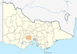 Location in Victoria | |||||||||||||
| Population | 31,496 (2015 est)[1] | ||||||||||||
| • Density | 14.93/km2 (38.66/sq mi) | ||||||||||||
| Established | 1994 | ||||||||||||
| Gazetted | 6 May 1994[2] | ||||||||||||
| Area | 2,110 km2 (814.7 sq mi) | ||||||||||||
| Mayor | Cr Allan Comrie | ||||||||||||
| Council seat | Ballan | ||||||||||||
| Region | Western Victoria | ||||||||||||
| State electorate(s) | |||||||||||||
| Federal Division(s) | Ballarat | ||||||||||||
 | |||||||||||||
| Website | Shire of Moorabool | ||||||||||||
| |||||||||||||
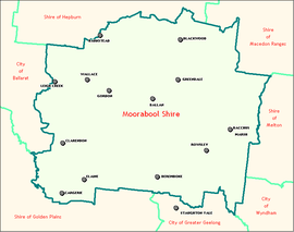
The Shire of Moorabool is a local government area in Victoria, Australia, located in the western part of the state. It covers an area of 2,110 square kilometres (810 sq mi) and, at the 2011 Census, had a population of 28,124.[3] It includes the towns of Ballan, Bacchus Marsh, Balliang, Mount Wallace, Myrniong, Blackwood, Greendale, Gordon, Korweinguboora and Mount Egerton, Bungaree, Elaine and Wallace. It was formed in 1994 from the amalgamation of the Shire of Bacchus Marsh, Shire of Ballan and parts of the Shire of Bungaree and City of Werribee.[2][4]
The Shire is governed and administered by the Moorabool Shire Council; its seat of local government and administrative centre is located at the council headquarters in Ballan, it also has service centres located in Bacchus Marsh and Darley. The Shire is named after the Moorabool River, a major geographical feature that meanders through the LGA.
Council
Current composition
The council is composed of four wards and seven councillors, with four councillors elected to represent the East Moorabool Ward and one councillor per remaining ward elected to represent each of the other wards.[5]
| Ward | Councillor | Notes | |
|---|---|---|---|
| Central Moorabool | Paul Tatchell | Deputy Mayor | |
| East Moorabool | Allan Comrie | Mayor | |
| Tonia Dudzik | |||
| David Edwards | |||
| John Spain | |||
| West Moorabool | Tom Sullivan | ||
| Woodlands | Pat Toohey | ||
Administration and governance
The council meets in the council chambers at the council headquarters in the Ballan Municipal Offices, which is also the location of the council's administrative activities. It also provides customer services at both its administrative centre in Ballan, and its service centre in Bacchus Marsh.
Localities
Localities which encompass the Shire of Moorabool include:
- Bacchus Marsh
- Ballan
- Balliang
(shared with Greater Geelong) - Balliang East
- Barkstead
- Barrys Reef
- Beremboke
- Blackwood
- Blakeville
- Bolwarrah
- Bullarook
(shared with Hepburn) - Bullarto South
(shared with Hepburn) - Bunding
- Bungal
- Bungaree
- Buninyong
(shared with Ballarat) - Cargerie
- Clarendon
- Claretown
- Clarkes Hill
- Coimadai
- Colbrook
- Dales Creek
- Darley
- Dunnstown
- Durham Lead
(shared with Ballarat and
Golden Plains) - Elaine
- Fiskville
- Glen Park
(shared with Ballarat) - Glenmore
- Gordon
- Greendale
- Grenville
(shared with Golden Plains) - Hopetoun Park
- Ingliston
- Korobeit
- Korweinguboora
(shared with Hepburn) - Lal Lal
- Leigh Creek
- Lerderderg
- Long Forest
- Maddingley
- Meredith
(shared with Golden Plains) - Merrimu
- Millbrook
- Mollongghip
(shared with Hepburn) - Morrisons
(shared with Golden Plains) - Mount Doran
- Mount Egerton
- Mount Wallace
- Myrniong
- Navigators
- Parwan
(shared with Melton) - Pentland Hills
- Pootilla
- Rowsley
- Scotsburn
(shared with Ballarat) - Spargo Creek
- Springbank
- Trentham
(shared with Hepburn) - Wallace
- Warrenheip
(shared with Ballarat) - Wattle Flat
(shared with Ballarat and Hepburn) - Yendon
References
- ↑ "3218.0 – Regional Population Growth, Australia, 2014–15". Australian Bureau of Statistics. Retrieved 29 September 2016.
- 1 2 Victoria Government Gazette – Online Archive (1837–1997). "S23 of 1994". State Library of Victoria. State Government of Victoria (published 9 May 1994). p. 1. Retrieved 10 January 2014.
|article=ignored (help) - ↑ Census QuickStats (2011). "Moorabool (S) – LGA25150". Australian Bureau of Statistics. Government of Australia. Retrieved 10 January 2014.
- ↑ Victoria Government Gazette – Online Archive (1837–1997). "S97 of 1994". State Library of Victoria. State Government of Victoria (published 15 December 1994). p. 10. Retrieved 10 January 2014.
|article=ignored (help) - ↑ Local Government in Victoria. "Moorabool Shire Council". Councillors. Moorabool Shire Council. Retrieved 8 May 2016.
External links
- Moorabool Shire Council official website
- Metlink local public transport map
- Link to Land Victoria interactive maps
Coordinates: 37°36′00″S 144°15′00″E / 37.60000°S 144.25000°E