Badin District
| Badin District ضلعو بدين | |
|---|---|
| District | |
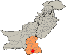
 Badin is located in the south of Sindh | |
| Country | Pakistan |
| Province | Sindh |
| Headquarters | Badin |
| Area | |
| • Total | 6,726 km2 (2,597 sq mi) |
| Population (2015) | |
| • Total | 2,255,600[1] |
| Time zone | PST (UTC+5) |
| Number of Tehsils | 6 |
The Badin District (Sindhi: ضلعو بدين, Urdu: ضلع بدین) is a district in the Sindh province of Pakistan. The total area of the district is 6,726 square kilometers.[2] It had a population of 1,136,636, in 1998, of which 16.42% were urban, according to the Pakistani census taken at the time.[3]
Headquartered at the city of Badin, the district is situated between 24°-5` to 25°-25` north latitude and 68 21’ to 69 20’ east longitude and is bounded on the north by the Hyderabad District, on the east by Mirpurkhas and Tharparkar districts, on the south by the Rann of Kutch, which also forms part of the disputed boundary with India, and on the west by Thatta and Hyderabad districts.
Administration
The district is administratively subdivided into the following talukas:[4]
With the introduction of the devolution system, the talukas have been subdivided into the Union Councils numbering 49, Tapas 109 and Dehs 511.
History
Badin was the center of the ancient Indus Valley Civilization. Islam came into the region by 711 CE. The areas remained under the control of the Islamic caliphate until it came under control of the Ghaznavids. In 1592, Sindh came under the direct rule of the Mughal emperors.[5]
Education
The University of Sindh, realizing the rights of acquiring education by the citizens of far-flung areas, the university established a campus in the region of Badin, called 'Laar'. Laar College, Badin (S.U.L.C) was established in order to provide the inhabitants of the area, particularly girls, of Laar region with the higher education at doorstep. Prof. Dr. Muhammad Siddique Kalhoro is the campus-coordinator of the Sindh University Laar Campus Badin.[6]
University of Sindh has provided all necessary State - of - Art facilities to cater to the needs of the students such as library and computer laboratory with the internet facility; well-qualified faculty has been appointed. The College offers 4- year (8- Semester) bachelor's degree programs in Business Administration, Commerce and Computer Science, PGD. Computer Science and B.Ed., M.Ed. & M.A. (Education).[6]
Railways
The main line runs from Badin to Hyderabad through the Matli taluka.[2]
Communications
The district has 55 post offices.[2] In 2003, telephone connections stood at 4,821.[2]
Badin Coal Field
Spread at the area of 1,110sq.km, 'Badin Coal Field' reserves around 1.358 billion metric tons of coal.[7]
References
- ↑ "Sindh population surges by 81.5 pc, households by 83.9 pc". Thenews.com.pk. 2 April 2012. Retrieved 2013-04-21.
- 1 2 3 4 Planning and Development Department, Sindh Government. Retrieved 10 June 2010
- ↑ Urban Resource Centre
- ↑ Local Govt. Department of Sindh - District of Badin
- ↑ History, Badin. "Badin history". YesPakistan. Archived from the original on 17 November 2011. Retrieved 8 November 2013.
- 1 2 University, Sindh. "Laar Campus of University of Sindh". University of Sindh. Archived from the original on 12 December 2013. Retrieved 8 November 2013.
- ↑ Badin, Coal Field. "Coal Field Badin". Sindh Coal. Retrieved 8 November 2013.
External links
Provincial capital: Karachi | ||
| Banbhore | 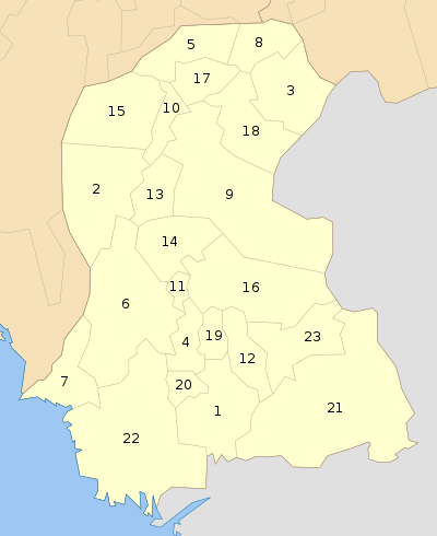 | |
| Hyderabad | ||
| Karachi | ||
| Larkana | ||
| Mirpur Khas | ||
| Sukkur | ||
| Shaheed Benazir Abad | ||
| Disputed | ||
Coordinates: 24°40′N 69°00′E / 24.667°N 69.000°E