Baikonur
| Baikonur Байқоңыр Байконур | |||
|---|---|---|---|
|
An aerial view of Baikonur | |||
| |||
 Baikonur Location in Kazakhstan | |||
| Coordinates: 45°37′0″N 63°19′0″E / 45.61667°N 63.31667°ECoordinates: 45°37′0″N 63°19′0″E / 45.61667°N 63.31667°E | |||
| Country | Russia - rented and administrated | ||
| Founded | 1955 | ||
| Incorporated (city) | 1966 | ||
| Area | |||
| • Total | 57 km2 (22 sq mi) | ||
| Elevation | 100 m (300 ft) | ||
| Population (2009)[1] | |||
| • Total | 36,175 | ||
| • Density | 630/km2 (1,600/sq mi) | ||
| Time zone | UTC+6 (UTC+6) | ||
| Postal code | 710501 | ||
| Area code(s) | +7 73622 | ||
| Vehicle registration | N | ||
| Website |
www | ||
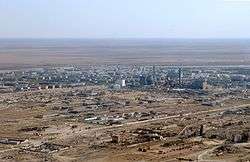


Baikonur (Kazakh: Байқоңыр, Bayqoñır; Russian: Байконур, Baykonur), formerly known as Leninsk (also, see Tyuratam), is a city of republic significance in Kazakhstan on the right bank of the Syr Darya river, rented and administered by the Russian Federation. It was constructed to service the Baikonur Cosmodrome and was officially renamed Baikonur by Russian president Boris Yeltsin on December 20, 1995. During the Soviet period, it was sometimes referred to as Zvezdograd (Star City).[2]
In 2009, the population of Baikonur was 36,175 (2009 Census results),[1] while in 1999, it was 28,776 (1999 Census results).[1]
The rented area is an ellipse measuring 90 km east to west by 85 km north to south, with the cosmodrome situated at the area's centre.
History
The original Baikonur (Kazakh for "wealthy brown", i.e. "fertile land with many herbs") is a mining town a few hundred kilometres northeast of the present location, near Dzhezkazgan in Kazakhstan's Karagandy Region. Starting with Vostok 1 in April 1961, the launch site was given this name to cause confusion and keep the location secret. (The original Baikonur's residents took advantage of the confusion by ordering and receiving many scarce materials before government officials discovered the deception.)[3] Baikonur's railway station predates the base and retains the old name of Tyuratam. This was the original Soviet railway station (railhead) on the Moscow to Tashkent Railway that the Cosmodrome was initially named after.
The fortunes of the city have varied according to those of the Soviet or Russian space program and its Baikonur Cosmodrome.
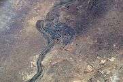
The Soviet government established the Nauchno-Issledovatel'skii Ispytatel'nyi Poligon N.5 (NIIIP-5), or Scientific-Research Test Range N.5 by its decree of 12 February 1955. The U-2 high-altitude reconnaissance plane found and photographed for the first time the Tyuratam missile test range (cosmodrome Baikonur) on 5 August 1957. See right for a composite satellite image of the early Tyuratam launch complex, the cosmodrome (30 May 1962).
Gallery
-

U-2 Photograph of R-7 Launch Pad in Tyura-Tam
-
Baikonur and Syr Darya River
-
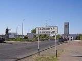
Entrance to the city
-

Kazakh boy wearing a national costume at the celebration of Nauryz event in Baikonur with a camel
See also
References
- 1 2 3 "Население Республики Казахстан" (in Russian). Департамент социальной и демографической статистики. Retrieved 8 December 2013.
- ↑ Barensky, C. Lardier, Stefan (2013). The Soyuz launch vehicle the two lives of an engineering triumph. New York: Springer. p. 189. ISBN 146145459X.
- ↑ Siddiqi, Asif A. Challenge To Apollo: The Soviet Union and the Space Race, 1945-1974. NASA. p. 284.
Further reading
- "Testing of rocket and space technology - the business of my life" Events and facts - A.I. Ostashev, Korolyov, 2001.;
- "Baikonur. Korolev. Yangel." - M. I. Kuznetsk, Voronezh: IPF "Voronezh", 1997, ISBN 5-89981-117-X;
- "Unknown Baikonur" - edited by B. I. Posysaeva, M.: "globe", 2001. ISBN 5-8155-0051-8
- "Rocket and space feat Baikonur" - Vladimir Порошков, the "Patriot" publishers 2007. ISBN 5-7030-0969-3
- A.I. Ostashev, Sergey Pavlovich Korolyov - The Genius of the 20th Century — 2010 M. of Public Educational Institution of Higher Professional Training MGUL ISBN 978-5-8135-0510-2.
- "Bank of the Universe" - edited by Boltenko A. C., Kiev, 2014., publishing house "Phoenix", ISBN 978-966-136-169-9
External links
| Wikimedia Commons has media related to Baikonur. |
- RussianSpaceWeb.com on Baikonur town
- Baikonur cosmodrome placemark
- Launch of the manned spacecraft Soyuz from the Baikonur Cosmodrome
-
 Baikonur travel guide from Wikivoyage
| Regions |  | |
|---|---|---|
| Metropolitan cities | ||
| Capital | | |
|---|---|---|
| Other cities | ||