Atyrau
| Atyrau Атырау | ||
|---|---|---|
| City | ||
|
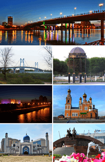
Clockwise from top: Central Bridge which connects Europe and Asia during the evening; Stand marking the European side of the city; Orthodox Church; Isatay and Makhambet Monument; Manjali Mosque; Ural River at night; Pedestrian Bridge over the Ural River. | ||
| ||
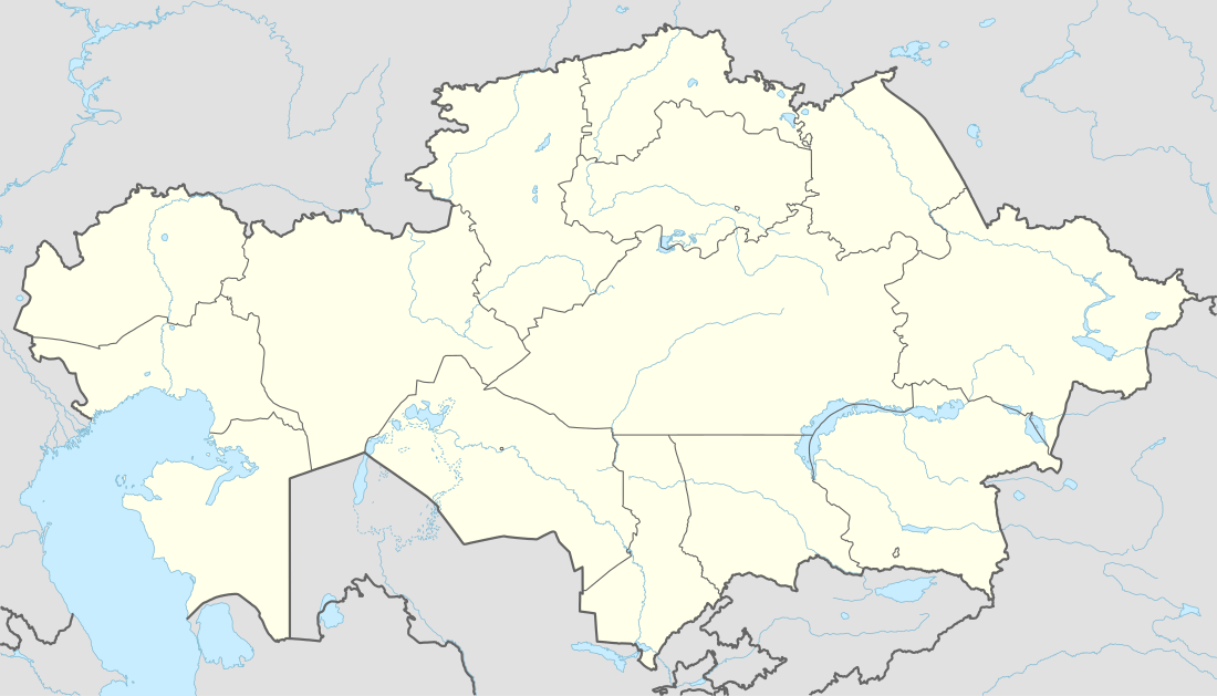 Atyrau Location in Kazakhstan | ||
| Coordinates: 47°07′0″N 51°53′0″E / 47.11667°N 51.88333°E | ||
| Country | Kazakhstan | |
| Region | Atyrau Region | |
| Founded | 1640 | |
| City status | 1885 | |
| Government | ||
| • Akim (mayor) |
Nurlybek Ozhaev (Нұрлыбек Ожаев) | |
| Elevation | -20 m (−70 ft) | |
| Population (2012) | ||
| • City | 163,221 | |
| • Metro | 221,585 | |
| Time zone | UTC+5 (UTC+5) | |
| Postal code | 060001 - 060011 | |
| Area code(s) | (+7) 7122 | |
| Vehicle registration | E, 06 | |
| Website |
atyrau | |

Atyrau (Kazakh: Атырау, Atıraw, اتىراۋ, pronounced [ɑtərɑ́w]; Russian: Атырау [ɐtɨˈraʊ]), known as Guryev (Russian: Гурьев [ˈɡurʲjɪf]) until 1991, is a city in Kazakhstan, and the capital of Atyrau Region. It is located at the mouth of the Ural River on the Caspian Sea, 2,700 kilometres (1,700 miles) west of Almaty and 351 kilometres (218 miles) east of the Russian city of Astrakhan.
Modern Atyrau is famous for its oil and fish industries. It has 154,100 inhabitants (2007), up from 142,500 (1999 census), 90% ethnic Kazakhs (up from 80%), the rest being mostly Russians and other ethnic groups such as Tatars and Ukrainians.
History
The wooden fort at the mouth of the Yaik River was founded in 1645 as Nizhny Yaitzky gorodok (literally, Lower Yaik Fort) by the Russian trader Gury Nazarov, a native of Yaroslavl, who specialized in trade with Khiva and Bukhara. The fort was plundered by the Yaik Cossacks, leading the Guriev family to rebuild it in stone (1647–62). Tsar Alexis sent a garrison of Streltsy to protect the fort from Cossack incursions. Despite these efforts, the Cossack rebel Stepan Razin held the town in 1667 and 1668. The fort gradually lost its strategic significance and was demolished in 1810. Between 1708 and 1992 the city was known as Guriev. The Kazakh name Atıraw means 'river delta'.
Geography
Atyrau (together with Aktau) is Kazakhstan's main harbour city on the Caspian Sea, Atyrau at the delta of the Ural River. Atyrau city is approximately 20 metres (66 feet) below sea level. The city is considered to be located both in Asia and Europe, as it is divided by the Ural River.
The city is a hub for the oil-rich Caspian Depression; because of this, many oil wells have been drilled in the Tengiz Field and Kashagan Field areas. An oil pipeline runs from Atyrau to Samara, where it joins the Russian pipeline system. A separate oil pipeline runs from the Tengiz field to the Russian Black Sea port of Novorossiisk.
Climate
Atyrau's climate is semi-arid (Köppen climate classification BSk), just shy of being classified as arid (Köppen climate classification BWk), with hot summers and cold winters. Precipitation is low throughout the year. Snow is common, though light, in winter. The lowest temperature on record is −37.9 °C (−36.2 °F), recorded in 1909, and the highest temperature is 42.7 °C (108.9 °F), recorded in 1984.[1] It is much more continental than areas further west on the European continent, with summers characterized by temperatures averaging 33 °C (91 °F) and lack of precipitation, resembling continental hot-summer mediterranean climates, and subarctic winters with little snow but with chilling temperatures. These vast temperature swings are more comparable to Siberia and the North American plains.
| Climate data for Atyrau | |||||||||||||
|---|---|---|---|---|---|---|---|---|---|---|---|---|---|
| Month | Jan | Feb | Mar | Apr | May | Jun | Jul | Aug | Sep | Oct | Nov | Dec | Year |
| Record high °C (°F) | 10.5 (50.9) |
15.0 (59) |
26.3 (79.3) |
32.5 (90.5) |
38.0 (100.4) |
41.9 (107.4) |
42.7 (108.9) |
41.9 (107.4) |
40.1 (104.2) |
29.6 (85.3) |
19.9 (67.8) |
11.8 (53.2) |
42.7 (108.9) |
| Average high °C (°F) | −2.8 (27) |
−1.8 (28.8) |
5.8 (42.4) |
17.2 (63) |
24.5 (76.1) |
30.8 (87.4) |
33.4 (92.1) |
31.6 (88.9) |
24.6 (76.3) |
15.3 (59.5) |
5.1 (41.2) |
−1.1 (30) |
15.2 (59.4) |
| Daily mean °C (°F) | −6.4 (20.5) |
−6.3 (20.7) |
0.8 (33.4) |
11.2 (52.2) |
18.4 (65.1) |
24.5 (76.1) |
26.8 (80.2) |
24.8 (76.6) |
18.0 (64.4) |
9.7 (49.5) |
1.3 (34.3) |
−4.3 (24.3) |
9.9 (49.8) |
| Average low °C (°F) | −9.4 (15.1) |
−9.9 (14.2) |
−3.1 (26.4) |
6.1 (43) |
12.8 (55) |
18.4 (65.1) |
20.5 (68.9) |
18.5 (65.3) |
12.3 (54.1) |
5.0 (41) |
−1.7 (28.9) |
−7.0 (19.4) |
5.2 (41.4) |
| Record low °C (°F) | −37.9 (−36.2) |
−37.4 (−35.3) |
−32.3 (−26.1) |
−12.3 (9.9) |
−2.3 (27.9) |
2.3 (36.1) |
8.1 (46.6) |
4.8 (40.6) |
−5.7 (21.7) |
−15.7 (3.7) |
−29.8 (−21.6) |
−35.8 (−32.4) |
−37.9 (−36.2) |
| Average precipitation mm (inches) | 14 (0.55) |
12 (0.47) |
15 (0.59) |
16 (0.63) |
23 (0.91) |
18 (0.71) |
10 (0.39) |
12 (0.47) |
8 (0.31) |
16 (0.63) |
18 (0.71) |
14 (0.55) |
176 (6.93) |
| Average rainy days | 4 | 4 | 6 | 8 | 9 | 7 | 6 | 5 | 5 | 8 | 10 | 6 | 78 |
| Average snowy days | 14 | 11 | 7 | 1 | 0 | 0 | 0 | 0 | 0 | 1 | 5 | 11 | 50 |
| Average relative humidity (%) | 84 | 80 | 74 | 58 | 50 | 45 | 45 | 46 | 52 | 64 | 80 | 84 | 64 |
| Mean monthly sunshine hours | 98 | 138 | 167 | 245 | 311 | 330 | 343 | 323 | 267 | 196 | 105 | 75 | 2,598 |
| Source #1: Pogoda.ru.net[1] | |||||||||||||
| Source #2: NOAA (sun, 1961–1990)[2] | |||||||||||||
Industry
Oil industry
The third biggest refinery in Kazakhstan is located in Atyrau.[3] Atyrau Refinery is operated by KazMunayGas and has a capacity of 16,600 m³/day (2012). A deep oil refining complex is under construction which is the final stage of complete reconstruction of Atyrau Oil Refinery. This project is designed to process 2.4 million tons/year of raw materials (oil and vacuum gas oil). The project will increase the depth of the oil processing at the refinery by 2016 to 85%. The volume of oil refining will reach 5.5 million tons per year.[4]
International relations
Twin towns — Sister cities
Atyrau is twinned with:
-
 Aktau, Kazakhstan
 - Oral, Kazakhstan
- Aktobe, Kazakhstan
-
 Astrakhan, Russia
 - Syktyvkar, Russia
-
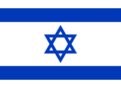 Ashdod, Israel
See also
References
- 1 2 "pogoda.ru.net Погода и Климат". Retrieved January 10, 2012.
- ↑ "Atyrary (Atyrau) Climate Normals 1961–1990". National Oceanic and Atmospheric Administration. Retrieved 13 May 2015.
- ↑ Company Overview of Atyrau Refinery LLP
- ↑ "Japanese Banks Provide $297.5 million Loan to Atyrau Oil Refinery". The Gazette of Central Asia. Satrapia. 15 August 2012.
External links
| Wikivoyage has a travel guide for Atyrau. |
| Wikimedia Commons has media related to Atyrau. |
Capital: Atyrau | ||
| Districts |  | |
| Major cities | ||
| Towns and villages |
| |
| Capital |  | |
|---|---|---|
| Other cities | ||
Coordinates: 47°07′N 51°53′E / 47.117°N 51.883°E