Bow, London
| Bow | |
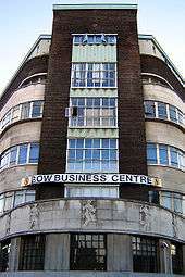
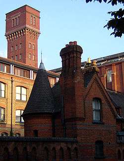 Former Bryant and May match factory |
|
 Bow |
|
| Population | 27,720 (2011 census Bow East and Bow West wards)[1] |
|---|---|
| OS grid reference | TQ365825 |
| – Charing Cross | 4.6 mi (7.4 km) W |
| London borough | Tower Hamlets |
| Ceremonial county | Greater London |
| Region | London |
| Country | England |
| Sovereign state | United Kingdom |
| Post town | LONDON |
| Postcode district | E3 E20 |
| Dialling code | 020 |
| Police | Metropolitan |
| Fire | London |
| Ambulance | London |
| EU Parliament | London |
| UK Parliament | Bethnal Green and Bow |
| London Assembly | City and East |
Coordinates: 51°31′47″N 0°01′44″W / 51.5298°N 0.0288°W
Bow (/ˈboʊ/) is a district in east London, England, in the London Borough of Tower Hamlets. It is built-up and mostly residential, and 4.6 miles (7.4 km) east of Charing Cross.
The name of the area was anciently Stratford, and "Bow" is an abbreviation of the medieval name Stratford-atte-Bow, in which "Bow" refers to a bridge built in the early 12th century. Bow is adjacent to the London 2012 Olympic Park, less than a mile away. A section of the district is part of the park.
Bow underwent extensive urban re-generation including the replacement or improvement of council homes, such redevelopment and rejuvenation coinciding with the staging of the 2012 Olympic Games at nearby Stratford.
History
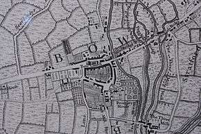
Bridges at Bowe
Stratforde was first recorded as a settlement in 1177, the name derived from its Old English meaning of paved way to a ford.[2] The ford originally lay on a pre-Roman trackway at Old Ford about 600 metres to the north, but when the Romans decided on Colchester as the initial capital for their occupation, the road was upgraded to run from the area of London Bridge, as one of the first paved Roman roads in Britain.[3] The 'paved way' is likely to refer to the presence of a stone causeway across the marshes, which formed a part of the crossing.
In 1110 Matilda, wife of Henry I, reputedly took a tumble at the ford on her way to Barking Abbey, and ordered a distinctively bow-shaped, three-arched bridge to be built over the River Lea, The like of which had not been seen before; the area became known variously as Stradford of the Bow, Stratford of the Bow, Stratford the Bow, Stratforde the Bowe, and Stratford-atte-Bow' (at the Bow)[4] which over time was shortened to Bow to distinguish it from Stratford Langthorne on the Essex bank of the Lea.[5] Land and Abbey Mill were given to Barking Abbey for maintenance of the bridge, who also maintained a chapel on the bridge dedicated to St Katherine, occupied until the 15th century by a hermit. This endowment was later administered by Stratford Langthorne Abbey.[6] By 1549, this route had become known as The Kings Way.
_p18b_-_Bow_Bridge.jpg)
Responsibility for maintenance of the bridge was always in dispute, no more so than with the Dissolution of the Monasteries, when local landowners who had taken over the Abbey lands were found responsible. The bridge was widened in 1741 and tolls were levied to defray the expense, but litigation over maintenance lasted until 1834, when the bridge needed to be rebuilt and landowners agreed to pay half of the cost, with Essex and Middlesex sharing the other. The bridge was again replaced in 1834, by the Middlesex and Essex Turnpike Trust, and in 1866 West Ham took responsibility for its upkeep and that of the causeway and smaller bridges that continued the route across the Lea. In 1967 this bridge was replaced by the Greater London Council with a two-lane flyover spanning the Blackwall Tunnel approach road, the traffic interchange, the River Lea and some of the Bow Back Rivers.[6] This has since been expanded to a four-lane road.
Religious life
In 1311 Bow remained an isolated village, often cut off from St Dunstan's, Stepney church by flood. Permission was given to build a chapel of ease to allow the residents a local place to worship. The land was granted by Edward III, on the King's highway, thus beginning a tradition of island church building.
In 1556, during the reign of Mary I of England and under the authority of Edmund Bonner, Bishop of London, many people were brought by cart from Newgate and burned at the stake in front of Bow Church, in one of the many swings of the English Reformation.[7]
In 1719, the parish became independent of Stepney and St Mary Stratford Bow consecrated. The parish included the Old Ford area, which has also been known as North Bow.
Chaucer and Stratford-atte-Bowe
A convent of Benedictine nuns was established at the nearby Priory of St Leonards, in modern Bromley-by-Bow. Geoffrey Chaucer immortalised this Priory in his Canterbury Tales:
- Ther was also a nonne, a prioresse,
- That of hir smylyng was ful symple and coy;
- Hire gretteste ooth was but by seinte loy;
- And she was cleped madame eglentyne.
- Ful weel she soong the service dyvyne,
- Entuned in hir nose ful semely,
- And frenssh she spak ful faire and fetisly,
- After the scole of stratford atte bowe,
- For frenssh of parys was to hire unknowe.[8]
This was a joking (Jill Mann, The Canterbury Tales, Notes to the General Preface) reference to the Prioress having learned the distinctive Anglo-Norman[9] dialect of French, from the Benedictine nuns. French still had the cachet of being the language of the royal court, but "English French" was by then considered rustic compared to the French of Paris. (see Bromley-by-Bow).
Goose Fair
Fairfield Road commemorates the Green Goose fair, held there on the Thursday after Pentecost.[10] A Green Goose was a young or mid-summer goose, and a slang term for a cuckold or a 'low' woman.[11] In 1630, John Taylor, a poet wrote At Bow, the Thursday after Pentecost, There is a fair of green geese ready rost, Where, as a goose is ever dog cheap there, The sauce is over somewhat sharp and deare., taking advantage of the double entendre and continuing with other verses describing the drunken rowdy behaviour of the crowds.[12] By the mid-19th century, the authorities had had enough and the fair was suppressed.[10]
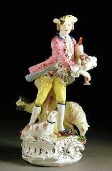
Bow porcelain
During the 17th century Bow and the Essex bank became a centre for the slaughter and butchery of cattle for the City market. This meant a ready supply of cattle bones, and local entrepreneurs Thomas Frye and Edward Heylyn developed a means to mix this with clay and create a form of fine porcelain, said to rival the best from abroad, known as Bow Porcelain. In November 1753, in Aris's Birmingham Gazette, the following advertisement appeared:
This is to give notice to all painters in the blue and white potting way and enamellers on china ware, that by applying at the counting-house at the china-house near Bow, they may meet with employment and proper encouragement according to their merit; likewise painters brought up in the snuff-box way, japanning, fan-painting, &c., may have an opportunity of trial, wherein if they succeed, they shall have due encouragement. N.B. At the same house a person is wanted who can model small figures in clay neatly.
The Bow China Works prospered, employing some 300 artists and hands, until about 1770, when one of its founders died. By 1776 all of its moulds and implements were transferred to a manufacturer in Derby. In 1867, during drainage operations at the match factory of Bell & Black at Bell Road, St. Leonard's Street, the foundations of one of the kilns were discovered*, with a large quantity of 'wasters' and fragments of broken pottery. The houses close by were then called China Row, but now lie beneath modern housing. Chemical analysis of the firing remains showed them to contain high quantities of bone-ash, pre-dating the claim of Josiah Spode to have invented the bone china process.[13] More recent investigations of documentary and archaeological evidence suggests the concern was to the north of the High Street and across the river.[14]
Bryant and May
In 1888, the match girls' strike occurred at the Bryant and May match factory in Fairfield Road. This was a forerunner of the suffragette movement fight for women's rights and also the trade union movement. The factory was rebuilt in 1911 and the brick entrance includes a depiction of Noah's Ark and the word 'Security' used as a trademark on the matchboxes. Match production ceased in 1979 and the building is now private apartments known as the Bow Quarter.[15]
Suffragettes
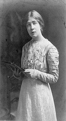
Emmeline Pankhurst began the Women's Social and Political Union (WSPU) in 1903 with her daughters Christabel and Sylvia. Sylvia became increasingly disillusioned with the Suffragette movement's inability to engage with the needs of working-class women like the match girls. Sylvia formed a breakaway movement, the East London Federation of Suffragettes, and based at 198 Bow Road, by the church, in a baker's shop. This was emblazoned with "Votes for Women" in large gold letters, and opened in October 1912. The local Member of Parliament, George Lansbury, resigned his seat to stand on a platform of women's enfranchisement. Sylvia supported him and Bow Road became the campaign office, culminating in a huge rally in nearby Victoria Park, but Lansbury was narrowly defeated and support for the project in the East End was withdrawn.
Sylvia refocused her efforts from Bow, and with the outbreak of World War I began a nursery, clinic and cost price canteen for the poor at the bakery. A paper, the Women's Dreadnought, was published to bring her campaign to a wider audience. At the close of war, the Representation of the People (Amendment) Act 1918 gave limited voting rights to property-owning women over the age of 30, and equal rights were finally achieved ten years later.
Pankhurst spent 12 years in Bow fighting for women's rights. She risked constant arrest[16] and spent a lot of time in Holloway Prison, often on hunger strike. She finally achieved her aim, and along the way had alleviated some of the poverty and misery and improved social conditions for all in the East End.
Railways
In 1843 the engineer William Bridges Adams founded the Fairfield Locomotive Works, where he specialized in light engines, steam railcars (or railmotors) and inspection trolleys, including the Fairfield steam carriage for the Bristol and Exeter Railway and the Enfield for the Eastern Counties Railway. The business failed and the works closed circa 1872, later becoming the factory of Bryant and May.
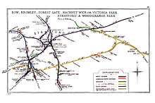
Bow was the headquarters of the North London Railway, which opened its locomotive and carriage workshops in 1853. There were two stations, Old Ford and Bow. During World War 2 the North London Railway branch from Dalston to Poplar through Bow was so badly damaged that it was abandoned.
Bow station opened in 1850 and was rebuilt in 1870 in a grand style, designed by Edwin Henry Horne and featuring a concert hall that was 100 ft long (30 m) and 40 ft wide (12 m). This became The Bow and Bromley Institute, then in 1887 the East London Technical College and a Salvation Army hall in 1911. From the 1930s it was used as the Embassy Billiard Hall and after the war became the Bow Palais, but was demolished in 1956 after a fire.[17]
Local government
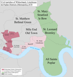
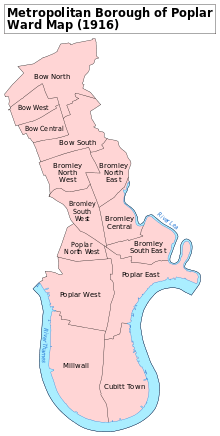
Bow formed a part of the medieval parish of Stepney until becoming an independent parish in 1719. The parish vestry then undertook this responsibility until a rising population created the need for the Poplar Board of Works in 1855. This was superseded by the Metropolitan Borough of Poplar in 1900 until it was absorbed into the London Borough of Tower Hamlets in 1965.[18]
Between 1986 and 1992 the name Bow applied to one of seven neighbourhoods to whom power was devolved from the council. This resulted in replacement of much of the street signage. Bow West[19] and Bow East[20] are two wards formed in 2002 that incorporate Old Ford and the eastern end of Bethnal Green (to Grove Road, parts of which used to comprise Mile End New Town, north of the Mile End Road). Bow lost its territory south of the Mile End Road to Bromley-by-Bow.[21] These boundary changes are driven by the need to ensure a comparable number of electors for each ward within the borough.
Governance
Local council facilities are grouped around Roman Road market in Old Ford. The local library, now called an Idea Store, is in Gladstone Place. A community and tenants' hall is nearby. Access to council services is dealt with by the Bow and North Poplar One Stop Shop, in Ewart Place.
Geography
It is often said that to be a true Cockney you need to be born within earshot of the sound of Bow Bells and that these are the bells of Bow Church in the heart of Bow. However, the saying actually refers to St Mary-le-Bow, which is approximately three miles west on Cheapside, in the City of London. The other central feature of Bow is the bridge across the River Lea. Today it is a four-lane flyover over the Lea and Blackwall Tunnel approach. The High Street has few active shops, with large-scale postwar housing to the south. The island church remains as a turning point for buses. The Blackwall Tunnel approach roads´ expansion from the two-lane road at the beginning of the 20th century to a six-lane urban motorway has occupied land at the expense of industry. What remains on the eastern side of the road is a canal-side enclave of small businesses and warehouses, with a large supermarket at the canal bridge to Three Mills.
Bow has become associated with the E3 postcode district, but a small part is in E15 and the southern half of Cadogan Terrace which is in E9. Most of the E15 section has been changed to E20 because this part covers the Olympic Park. E3 includes Bromley-by-Bow, Old Ford, Mile End and the transpontine Three Mills in Newham. The modern Tower Hamlets wards of west and east Bow are associated more with the postcode than the settlement, and bounded by the Mile End Road in the south; the River Lea to the east; Victoria Park to the north; and Grove Road in the west.
The Hertford Union Canal links the River Lee Navigation and the Regent's Canal, running west from Old Ford Lock, along the south side of Victoria Park and linking at a basin, just to the west of Grove Road and the park, in the north of Mile End.
Nearby places:
Landmarks
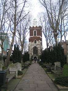
St Mary's Church stands on the traffic island in Bow Road, called Bow Church but not to be confused with St Mary-le-Bow in the City of London which has the famous Bow bells. Part of the church dates back to 1311. The base of the tower dates back to the late 15th century and the top of the tower was rebuilt after bomb damage in the Second World War.[22]
A statue of William Ewart Gladstone stands outside Bow Church. It was donated by Theodore H. Bryant, part-owner of the Bryant and May match factory.[23]
A memorial to George Lansbury (1859–1940) stands on the corner of Bow Road and Harley Grove, near 39 Bow Road, his family home in the constituency until it was destroyed in the Blitz.[24] It describes him as "A great servant of the people". Lansbury was twice Mayor of Poplar and MP for Bromley and Bow. In 1921, he led the Poplar Rates Rebellion. His daughter-in-law, Minnie Lansbury, was one of the 30 Poplar councillors sent to prison, and died six weeks after leaving prison. A memorial clock to her is over a row of shops on Bow Road, near the junction with Alfred Street.[25]
The original Poplar Town Hall is on the south side of Bow Road, near the DLR station. It continues in use for registrations of births and marriages as Bromley Public Hall. It was rebuilt in the 1920s at the corner of Bow Road and Fairfield Road, now in a dilapidated condition and used as commercial offices. It contains the Poplar Assembly Rooms, now no longer used. The Builders, by sculptor David Evans is a frieze on the face of the building, unveiled by Lansbury on 10 December 1938: the Portland Stone panels commemorate the trades constructing the Town Hall and symbolise the borough's relationship with the River Thames and the youth of Poplar.[26]
In 2000 and 2001 the Big Brother UK house was at Three Mills Studios in nearby Newham, often reported as Bow because the studios are in the E3 postal district.
Education
Old Ford, St.Agnes, Old Palace, Chisenhale,[27] Olga[28] and Malmesbury[29] primary schools are located in Bow, as is Bow School and Central Foundation Girls School on Bow Road.[30] Cherry Trees School[31] is a specialist primary school located at Campbell Road in Bow.
Transport
Rail
The nearest station is Bow Road for London Underground services on Bow Road and Bow Church for the Docklands Light Railway next to Bromley-by-Bow.
Buses
London Buses 8, 25, 108, 205, 276, 277, 309, 323, 339, 425, 488 and D6, D8, N8 and N205 all operate within the area.
Roads
Bow is connected to the National Road Network at the junction of the A12 East Cross Route and A11 Mile End Road. The proximity of tube stations mean that parking restrictions apply throughout the area.
Cycling
There is the Cycle Superhighway CS2 running from Stratford to Aldgate on the A11 as well as the Hertford Union Canal towpath and Lea Valley Walk.
Waterways
Access to the Lee Navigation is via the towpath at Three Mills. South leads to the River Thames, but the towpath can often be blocked. North leads to Duckett's Cut (the Hertford Union Canal), which provides access to Victoria Park and joins the Regent's Canal near Mile End. Proceeding north along the Lea leads to Hackney Marshes. As this is within the Olympic Park the towpath may be closed unpredictably while building works are undertaken.
See also
- List of people from Tower Hamlets
- Bow Group (centre-right think tank that first met in Bow)
- Kingsley Hall, in nearby Bromley-by-Bow
- Bromley Hall, the Tudor Manor House for Bromley and Bow
References
- ↑ "Tower Hamlets wards population 2011".
- ↑ Mills, D., Oxford Dictionary of London Place Names, (2000)
- ↑ 'Bethnal Green: Communications', A History of the County of Middlesex: Volume 11: Stepney, Bethnal Green (1998), pp. 88-90 accessed: 15 November 2006
- ↑ The Humanities Research Institute - Historical alternative names for Bow, London
- ↑ How Stratford became Bow Archived 20 December 2006 at the Wayback Machine. (East London History)
- 1 2 'West Ham: Rivers, bridges, wharfs and docks', A History of the County of Essex: Volume 6 (1973), pp. 57-61 accessed: 14 November 2006.
- ↑ John Foxe's Book of Martyrs Archived 3 September 2005 at the Wayback Machine. - The Martyrdome of Hugh Lauerocke & Iohn Apprice, at Stratford the Bow. An.1556. 15 May. accessed: 18 Nov 2006
- ↑ Line 125. Chaucer: The Canterbury Tales accessed on 14 Nov 2006
- ↑ "With Tongues".
- 1 2 The Copartnership Herald, Vol. I, no. 7 (September 1931) Archived 12 November 2006 at the Wayback Machine. accessed 14 Nov 2006
- ↑ A Dictionary of Archaic and Provincial Words, Obsolete Phrases, Proverbs James Orchard Halliwell-Phillipps pp. 416 (Smith, 1860)
- ↑ Green Goose Fair, in The Newe Metamorphosis BL Add. MS 14826, ff. 234r-40v (University of Bonn) Archived 19 July 2011 at the Wayback Machine. accessed 5 Dec 2007
- ↑ 'Industries: Pottery: Bow porcelain', A History of the County of Middlesex: Volume 2: General; Ashford, East Bedfont with Hatton, Feltham, Hampton with Hampton Wick, Hanworth, Laleham, Littleton (1911), pp. 146-50 accessed: 18 November 2006
- ↑ Adams, E. and Redstone, D. Bow Porcelain pp.231 (London 1991)
- ↑ Exploring East London Archived 28 January 2007 at the Wayback Machine. accessed 27 Mar 2007
- ↑ "One of Sylvia's first actions occurred when she climbed a cart, in nearby Bromley High Street, and commenced to speak. Unfortunately, no one listened, she picked up a rock and threw it through the window of Selby's Undertakers. Her colleagues smashed windows in nearby buildings, and were taken to Bow Police station."
- ↑ Bow (Disused stations, site record) accessed 23 Oct 2007
- ↑ Guide to the Local Administrative Units of England, Vol. I, F. A. Youngs 1979
- ↑ Bow West (ward) councillors Archived 15 February 2007 at the Wayback Machine. accessed 5 April 2008
- ↑ Bow East (ward) councillors Archived 15 February 2007 at the Wayback Machine. accessed 5 April 2008
- ↑ Tower Hamlets Borough Council Election Maps 1964-2002 accessed 14 April 2007
- ↑ There is a local belief that this Statforde-atte-Bow was concerned with the legend of Dick Whittington. It is suggested that The Black Cat was in fact a barge travelling the River Lea
- ↑ statue Archived 28 January 2007 at the Wayback Machine.
- ↑ Labour History (book review) accessed 29 Mar 2007
- ↑ Minnie Lansbury Memorial Clock Archived 28 January 2007 at the Wayback Machine.
- ↑ Public Monument & Sculpture Association Archived 16 July 2011 at the Wayback Machine. date accessed 1 April 2007
- ↑ Chisenhale Primary website accessed 5 April 2008
- ↑ Olga Primary website accessed 5 April 2008
- ↑ Malmesbury Primary website accessed 5 April 2008
- ↑ "Archived copy". Archived from the original on 12 September 2011. Retrieved 2011-10-11.
- ↑ http://www.lgfl.net/lgfl/leas/tower-hamlets/schools/cherry-trees/
External links
| Wikimedia Commons has media related to Bow, London district. |
- Bow West and Bow East wards are within the Borough's Local Area Partnership 5. Key areas of concern and action relate to community safety, access to health care provision and activities for young people, especially in the Victoria Park area.
- Bow Arts Trust
