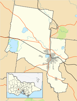
Ballarat East, Victoria
| Ballarat East Ballarat, Victoria | |||||||||||||
|---|---|---|---|---|---|---|---|---|---|---|---|---|---|
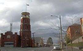 Former East Ballarat Civic Area on the corner of Barkly and East Streets. The Ballarat Fire Station is on the left, the old Library and Ballarat Secondary College are on the right. | |||||||||||||
 Ballarat East | |||||||||||||
| Coordinates | 37°33′48″S 143°52′08″E / 37.5632°S 143.869°ECoordinates: 37°33′48″S 143°52′08″E / 37.5632°S 143.869°E | ||||||||||||
| Population | 4,995 (2006 census)[1] | ||||||||||||
| Postcode(s) | 3350 | ||||||||||||
| Location | 3 km (2 mi) from Ballarat Central | ||||||||||||
| LGA(s) | City of Ballarat | ||||||||||||
| State electorate(s) | |||||||||||||
| Federal Division(s) | Ballarat | ||||||||||||
| |||||||||||||
Ballarat East is a suburb of Ballarat in Victoria, Australia. The suburb covers a large area east (and also north) of the CBD. It is the oldest area in Ballarat and was once also a municipality known as the Ballarat East Town Council between 1859 and 1921. The population of Ballarat East at the 2006 census was 4,995[1] making it the fifth most populated in the Ballarat urban area.
History
The discovery of goldfields in 1851 led to heavy immigration. In 1854, in their resistance of an arbitrary tax, gold miners in the area came into armed conflict with the authorities. A commission was appointed to investigate their grievances and a charter was granted to the town in 1855.[2] Ballarat East Post Office opened on 1 December 1857 and was replaced by the Bakery Hill office in 1992.[3]
The Ballarat East goldfield, which consisted of three distinct areas known as Ballarat East, Ballarat West and Nerrina, produced over 1.9 million ounces of gold from vein systems and over 16 million ounces from adjacent alluvial deposits. At the turn of the 20th century, these alluvial goldfields were the richest ever opened. As these surface deposits were exhausted the quartz reefs at deep levels were exploited and several mines worked at depths exceeding 600 metres.[2]
Main Street developed into the principal commercial area in the Ballarat district. Its mostly tents and timber buildings were destroyed by a series of fires during the 1860s and the commercial area shifted to the planned area of Ballarat West, specifically Sturt and Lydiard Streets.
Municipal status, town hall and civic centre
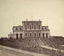
Ballarat East was one of the first areas of Ballarat to gain municipal status. In 1859 the newly formed Ballarat East Town Council acquisioned land in what was to become the Barkly Street civic area and on 26 December 1861 the foundation stone was laid for the Ballarat East Town Hall which was built in a Renaissance Revival architecture style and set in formal gardens. It was completed the following year along with the Ballarat East Free Library next door[4] and the Ballarat fire station, a new headquarters for the fire brigade formed in 1856) was erected a few years later in 1864.[5]
Ballarat East had its own railway station in the 1860s (only the goods sheds remain), built shortly after Ballarat West's station. It became an important junction for branch lines before being closed in the 1960s and its platforms demolished.
The East Ballarat Town Council was amalgamated with Ballarat West Town Council in 1920-1921 to become the City of Ballarat. After this time there was indecision as to how to use the old hall. In 1927 the Ballarat Teachers College moved there however during the great depression the town hall was mostly unused and was finally demolished in 1936 after years of speculation of its use as a girls' school or headquarters for the Ballarat Historical Society. The gates to the hall's once extensive gardens remain.
Transport
The main form of transport is the automobile. The suburb has several key collector roads. The largest road is Victoria Street (named for Queen Victoria), a dual carriageway which forms the main eastern entrance to Ballarat. In the north is Humffray Street (named for local politician John Basson Humffray), which forms a major east-west route. In the west is Main Road and Barkly Street (named for the Victorian Governor, Sir Henry Barkly). Along the south is another major east-west route, Eureka Street.
Buses provide the only means of public transport and several services are available. Route 8 (Eureka) and 9 (Canadian) travel along Eureka Street, while Route 7 (Brown Hill) service runs along Humffray and Victoria Streets. Route 10 (Buninyong) services part of the western edge along Main Road.[6]
Although the Ballarat-Melbourne railway runs the length of the suburb, the local railway station, once an important interchange, located near the Humffray Street level crossing, was closed in the 1960s and has been largely demolished.
Sport
At its furthest west point, East Ballarat is home to the Eastern Oval, one of Ballarat's oldest and largest enclosed stadiums which hosts Australian rules football and cricket matches. The stadium is home to the East Point Football Club of the Ballarat Football League and also the Golden Point Cricket Club and has also been mooted as a potential Australian Football League venue.[7] The recreational facility also includes netball courts and clubs and the lawn bowls club, Ballarat East Bowling Club.
Golfers play at the course of the Mount Xavier Golf Club on Fortune Street.[8]
Notable persons
1996 Olympic Gold Medallist in Shooting, Russell Mark, was educated at Brown Hill Primary School and Ballarat East High School. He was raised at a property in Boundary Road, Brown Hill.
References
- 1 2 Australian Bureau of Statistics (25 October 2007). "Ballarat East (L) (State Suburb)". 2006 Census QuickStats. Retrieved 2009-01-06.
- 1 2
 One or more of the preceding sentences incorporates text from a publication now in the public domain: Chisholm, Hugh, ed. (1911). "Ballarat and Ballarat East". Encyclopædia Britannica. 3 (11th ed.). Cambridge University Press. p. 269.
 - ↑ Premier Postal History, Post Office List, retrieved 2008-04-11
- ↑ http://vhd.heritage.vic.gov.au/places/heritage/59
- ↑ http://vhd.heritage.vic.gov.au/places/heritage/1441
- ↑ Ballarat bus network map
- ↑ Niall, Jake (2009-03-03). "Push for Ballarat as an AFL venue". The Sydney Morning Herald.
- ↑ Golf Select, Mount Xavier, retrieved 2009-05-11
See also
|