Ballyvourney
| Ballyvourney Baile Bhúirne | |
|---|---|
| Village | |
 Location in Ireland | |
| Coordinates: 51°56′41.2″N 9°9′47.67″W / 51.944778°N 9.1632417°WCoordinates: 51°56′41.2″N 9°9′47.67″W / 51.944778°N 9.1632417°W | |
| Country | Ireland |
| Province | Munster |
| County | County Cork |
| Irish Grid Reference | W195770 |
| Baile Bhúirne is the only official name as it is situated in a Gaeltacht (Irish-speaking area). | |
Ballyvourney (Irish: Baile Bhúirne, meaning "Town of the Beloved", also spelled Baile Mhúirne, Irish pronunciation: [ˈbˠalʲə ˈvʷuːrˠnʲə] ),[1] is a Gaeltacht village in south-west County Cork, Ireland. It is a civil parish in the barony of Muskerry West and is also an ecclesiastical parish in the Roman Catholic Diocese of Cloyne[2]
Location and access
The village stretches along the N22 road which links Cork city (to the south east) with Killarney (to the north west). The nearest large town is Macroom while the nearest international airport is Cork Airport. There is a proposal to construct 22 km of dual carriageway from Coolcour at the eastern side of Macroom, bypassing Macroom to the north and finishing west of Ballyvourney.[3]
Physical geography and political subdivisions
The village lies on the River Sullane:
"The river Sullane has its source in the parish, in the mountains bordering on the county of Kerry, and after intersecting it longitudinally pursues an eastern course through the parish of Clondrohid to the town of Macroom, to the east of which, at the distance of a mile, it discharges itself into the river Lee;"[4]
In this part of Cork, the rivers mainly drain longitudinally from west to east; this is true of the Lee and the Munster Blackwater. In between these rivers lies the valley of the Sullane. To the north of the parish, the Derrynasaggart Mountains and the Boggeragh Mountains separate the valley from the Blackwater valley. To the south, the upland area of Reananerree and the Shehies separate it from the Lee valley. The surrounding district of Muskerry straddles the counties of Cork and Kerry. The highest point in the parish, at 694m, is Mullaghanish (Irish: Mullach an Ois) located just northeast of the village.
While it is the western part of the county, it would not be considered to be part of the area informally known as West Cork because it lies north of the river Lee. Neither would it be part of the Golden Vale unlike the rich pasture towns to the north of the Boggeragh mountains (e.g. Charleville). The mountainous terrain and poor quality of the land has instead made it a virtual enclave within the county, best expressed in the old Gaelic tuatha of Muskerry. As the tuatha was relatively less desirable from an economic viewpoint, it may explain why the Gaelic way of life persisted into the 20th century and why Muskerry attained Gaeltacht status.
Bantry Bay is the district's nearest point to the sea. It is accessed by bad minor roads over the Reananerree uplands to the neighbouring Gaeltacht parish of Béal Átha an Ghaorthaidh where the R584 road crosses the Lee, passes the Shehy Mountains via the Pass of Keimaneigh (Irish: Céim an Fhia) (meaning the "pass of the deer's leap") and thence to Ballylickey.
More specifically, it is one of the 24 civil parishes in the barony of Muskerry West. The barony is the namesake of Baron Muskerry. There are 47 townlands in the civil parish.
| Townlands in the civil parish | |
|---|---|
| Name in Irish | Name in English |
| Baile Mhic Íre | Ballymakeery |
| Barr Duínse | Bardinch |
| Cathair Chearnaigh | Cahercarney |
| An Cheapach Thiar | Cappagh West |
| An Cheapach Thoir | Cappagh East |
| Na Cillíní | Killeen |
| Cnoc an Iúir | Knockanure |
| Com an Ghadhair | Coomnagire |
| Com na Cloiche | Coomnaclohy |
| Com Uí Chlúmháin | Coumaclovane |
| Cúil an Bhuacaigh | Coolavokig |
| Cúil an Mhothair | Coolavoher |
| Cúil Aodha | Coolea |
| An Chúil Iarthach | Coolierher |
| Cúil na Cathrach | Coolnacaheragh |
| Daingean na Saileach | Dangansallagh |
| Doire an Chuilinn | Derreenaculling |
| An Doire Leathan | Derrylahan |
| Doire na Sagart | Derrynasaggart |
| Na Doirí | Derree |
| An Doirín Álainn | Derreenaling |
| Na Foithrí | Fuhiry |
| Gort an Acra | Gortanacra |
| Gort na Fuinseann | Gortnafunshion |
| Gort na gCros | Gortnagross |
| Gort na Scairte | Gortnascarty |
| Gort na Tiobratan | Gortnatubbrid |
| Gort Uí Raithile | Gortyrahilly |
| An Inse Mhór | Inchamore |
| An Lománach Bheag | Lumnagh Beg |
| An Lománach Mhór | Lumnagh More |
| Magh Réidh | Flats |
| Na Millíní | Milleeny |
| An Muirneach Beag | Murnaghbeg |
| An Ráth Thiar | Rath West |
| An Ráth Thoir | Rath East |
| An Rathúnach Thiar | Rahoonagh West |
| An Rathúnach Thoir | Rahoonagh East |
| Ré na bPobal | Reanabobul |
| Screathan na nGabhann | Scrahanagown |
| An tSeanchluain | Shanacloon |
| An Seantóir | Glebe |
| An Sliabh Riabhach | Slievereagh |
| An Tóchar | Togher |
| Tonn Láin | Toonlane |
| Na hUláin Thiar | Ullanes West |
| Na hUláin Thoir | Ullanes East |
.png)
For electoral purposes, the parish lies in the Rural District of Macroom, in the District electoral division (DED) of An Sliabh Riabhach. Other DEDs within that rural district include Aghinagh, Aglish, Béal Átha an Ghaorthaidh, Cannaway, Ceann Droma, Cill na Martra, Claonráth, Clondrohid, Clonmoyle, Doire Fhínín, Gort na Tiobratan, Greenville, Inchigeelagh, Kilberrihert, Macloneigh, Magourney, Mashanaglass, Na hUláin, Rahalisk and Warrenscourt.[5] The DED is part of the Cork North–West constituency for elections to Dáil Éireann.
History
Historically, the people of Múscraige had the Corcu Loígde as their overlords. However, they switched allegiance to the Eóganachta and facilitated their rise to power as Kings of Munster. In "Griffith's Valuation of Ireland (1837)",[6] 548 unique records are recorded in the civil parish. Of these, the top 11 surnames accounted for over half over the entries. The top 15 surnames (after aggregating for common misspellings) recorded, from greatest to least, are: Lynch, Keleher, Twomey, Healy, Lucey, Quill, Leehane, Murphy, Riordan, Sweeny, Herlihy, Buckley, McCarthy, Creedon, Dinneen. The townlands with the most recorded surnames, from greatest to least, are: Coolavokig, Derrylahan, Slievereagh, Ballymakeery, Gortnatubbud, Dangansallagh, Derreenaling, Knockanure, Milleeny and Coolea.
Ballyvourney today
Tourism and culture
Today, the district gives its name to the Muskerry Gaeltacht which is an officially designated Irish-speaking area. While the inhabitants of the area know Irish well, English has been the predominant household and community language since the 1920s. The area's Gaeltacht status draws visitors - as does its architectural heritage.
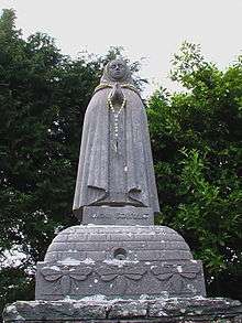
The town is associated with Saint Gobnait and is the site of her abbey, cells and St. Gobnait's Well. Her Pattern Day, February 11, is still celebrated by the community. During a Mass at the well, everyone takes water from it. According to legend, Gobnait was born in County Clare in the 6th century. Fleeing from Clare, she took refuge in the Aran Islands, where she encountered an angel who instructed her to go on a journey. The angel told her that when she came upon nine white deer, that would be her place. Travelling south, she came to Clondrohid where she found three white deer. She followed them to Killeens, Ballymakeera where she saw six more. When she found the nine white deer in Baile Bhuirne, she stayed and founded a convent. The remains of the convent are still the locus of pilgrimage, which while it is ostensibly Christian, may well be pagan in origin.[7]
The composer Seán Ó Riada is buried in the cemetery there. The abbey contains an example of a Sheela na Gig and there are a number of stone circles, stone rows and fulachtaí fia in the area.
The poet Seán Ó Ríordáin was born in the town and is also buried in its cemetery. Ballyvourney is also the home of Ionad Cultúrtha[8] which is a regional cultural centre for the traditional and contemporary arts. It holds many music and visual art events.
The village gives its name to an Irish dance figure - the Baile Bhuire Set[9]
Amenities and attractions
St. Gobnet's Wood is an old 30 ha woodland mainly planted in old Sessile Oak.
The local national school is called Scoil Aban Naofa and is named after Aban, a saint associated with the area.
The secondary school, Coláiste Ghobnatan, was formed in 1989 following the merger of Coláiste Iosagáin and Scoil Ghobnatan. According to the school principal, Breandán O Lionáird,
"The College is named in honour of Saint Gobnait, patron Saint of Baile Bhúirne and indeed we place all our work under her protection.".[10]
The grounds of "Coláiste Íosagáin", a former De La Salle college, was where Song for a Raggy Boy was filmed.
The film The Wind That Shakes the Barley was also filmed in nearby locations.

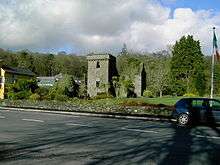
The bars and restaurants in the village are "The Mills Inn", "The Abbey Hotel", "The Hibernian", "The Crúiscín Lán"and "The Village Takeaway & Diner". The Mills Inn is built on the site of the former police barracks.
Cultural events include:[11]
- Patron Saint's Day (Irish: Lá Pátrúin), February 11.
- Whit Sunday feast day.
- Ballyvourney - Coolea Annual Show (Irish: Taispeántas Bhaile Bhúirne), College Field.
- Cultural & Heritage Centre (Irish: Ionad Cultúrtha Baile Bhúirne) which also holds educational programmes and traditional music concerts.
- Irish language courses organised by Gael-Linn in the Irish College (Irish: Coláiste Bhaile Bhúirne).
Economy
Employment opportunities in Ballyvourney range from agricultural, industrial to hospitality sectors. Údarás na Gaeltachta provide grants for businesses, many of which are situated in Ballyvourney's industrial estate.
Sport
- The Senior Gaelic football club, Naomh Abán GAA, has a number of championship titles to its name. Anthony Lynch, a native of Ballyvourney and a player on the local football team also plays for the Cork senior football team.
- Sullane F.C. is the local soccer club. The team competes in the West Cork league in senior and underage divisions.
See also
References
- ↑ Placenames Database of Ireland
- ↑ Official website of the Diocese of Cloyne. List of 46 parishes
- ↑ "Road Scheme Activity". TII. TII-Transport Infrastructure Ireland. Retrieved 19 November 2015.
This scheme will involve the construction of 22km of Type 2 dual carriageway from Coolcour at the eastern side of Macroom, bypassing Macroom to the north and finishing west of Ballyvourney.
- ↑ Lewis, A Topographical Dictionary of Ireland", 1837, Ballyvourney
- ↑ "Electoral (Amendment) Act 2009: Schedule". Irish Statute Book database. Retrieved 29 September 2010.
- ↑ Griffith's Valuation of Ireland (1837)
- ↑ Siofra Geoghegan, "Gobnait: Woman of the Bees"
- ↑ http://www.ionadculturtha.ie
- ↑ The Baile Bhuire Set
- ↑ Coláiste Ghobnatan official website
- ↑ Visitor Guide to Gaeltacht Mhúscraí
External links
| Wikimedia Commons has media related to Ballyvourney. |