Balsam Lake (Ontario)
| Balsam Lake | |
|---|---|
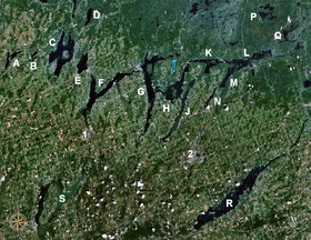 The Kawartha lakes with Balsam Lake (marked 'C') | |
| Location | Kawartha Lakes, Ontario |
| Group | Kawartha Lakes |
| Coordinates | 44°35′N 78°50′W / 44.583°N 78.833°WCoordinates: 44°35′N 78°50′W / 44.583°N 78.833°W |
| Primary inflows | Gull River |
| Primary outflows | Balsam River, Trent Canal |
| Basin countries | Canada |
| Max. length | 16 km (9.9 mi) |
| Max. width | 3 km (1.9 mi) |
| Max. depth | 15.24 m (50.0 ft) |
| Surface elevation | 256.3 meters (841 ft) |
| Islands | Grand Island, Hogg Island, Ball Island, Delamere Island, Ant Island, Cherry Island |
| Settlements | Coboconk |
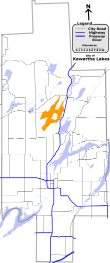
A map of the city of Kawartha Lakes with Balsam Lake highlighted
Balsam Lake is a lake located in the Kawartha Lakes region of south central Ontario, Canada. It is 16 km long and averages 3 km wide, though its actual width varies due to the many large bays the carve its shoreline. The Gull River empties into the lake.
The lake is the highest point of the Trent-Severn Waterway; from here, the waterway descends to Georgian Bay in the northwest, and to Lake Ontario in the southeast.[1]
The village of Coboconk, Ontario is located on the north side of the lake. Balsam Lake Provincial Park is also located on the lake.[2]
The lake offers excellent fishing for bass, walleye, and muskie. Mackenzie Bay in West Bay is a popular spot for boats to congregate on a warm summer day.[3]
References
- ↑ Angus, James T. (1999). A Respectable Ditch: A History of the Trent-Severn Waterway, 1833–1920. McGill-Queen's Press. p. 80. ISBN 978-0-7735-1821-6. Retrieved 2009-08-07.
- ↑ "Ontario Parks - Balsam Lake". Retrieved 2009-08-07.
- ↑ "Fishing Facts for Balsam Lake". Retrieved 2012-10-19.
City of Kawartha Lakes | |||||||||||
|---|---|---|---|---|---|---|---|---|---|---|---|
| Towns |  | ||||||||||
| Villages and unincorporated communities |
| ||||||||||
| Former townships | |||||||||||
| Major lakes |
| ||||||||||
| Topics | |||||||||||
1) This area lies on the border of an adjacent region, but is part of the Kawartha Lakes census. | |||||||||||
This article is issued from Wikipedia - version of the 10/24/2016. The text is available under the Creative Commons Attribution/Share Alike but additional terms may apply for the media files.