Sturgeon Lake (Ontario)
| Sturgeon Lake | |
|---|---|
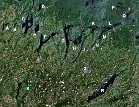 The Kawartha lakes with Sturgeon Lake (marked 'F') | |
| Location | Kawartha Lakes, Ontario |
| Group | Kawartha Lakes |
| Coordinates | 44°28′N 78°43′W / 44.467°N 78.717°WCoordinates: 44°28′N 78°43′W / 44.467°N 78.717°W |
| Primary inflows | Fenelon River, Scugog River |
| Basin countries | Canada |
| Max. length | 25 km (16 mi) |
| Max. width | 3 km (2 mi) |
| Surface elevation | 246 m (807 ft) |
| Settlements | Lindsay, Fenelon Falls, Sturgeon Point, Bobcaygeon, Dunsford |
Sturgeon Lake is a lake in the Kawartha Lakes region of Ontario, Canada. It is part of the Trent-Severn Waterway. The lake is Y shaped and has the communities of Fenelon Falls, Lindsay, Sturgeon Point and Bobcaygeon at the north-west, south, central and north-east points of the Y respectively. The lake is approximately 25 km (16 mi) from the southern to the north-eastern extremes, the longer axis.
Inflow and Outflow
The Scugog River flows into the lake at the southern apex. Cameron Lake also flows into this lake, via the Fenelon River at the north-western extreme. Emily Creek empties into the lake at the middle south.
The lake outflow is through the Big Bob and Little Bob channels of the Bobcaygeon River at the north-east of the lake.
Fish species
Game fish species include large and small mouth bass, muskie, and walleye.
Sources
| Wikimedia Commons has media related to Sturgeon Lake (Ontario). |
- Atlas of Canada topographic maps 31D7 and 31D10 retrieved 2007-11-06
City of Kawartha Lakes | |||||||||||
|---|---|---|---|---|---|---|---|---|---|---|---|
| Towns |  | ||||||||||
| Villages and unincorporated communities |
| ||||||||||
| Former townships | |||||||||||
| Major lakes |
| ||||||||||
| Topics | |||||||||||
1) This area lies on the border of an adjacent region, but is part of the Kawartha Lakes census. | |||||||||||