Barceloneta, Puerto Rico
| Barceloneta, Puerto Rico | |||
|---|---|---|---|
| Municipality | |||
| |||
| Nickname(s): "La Ciudad de las Piñas", "La Ciudad Industrial," "El Pueblo de los Indios", "El Pueblo de Sixto Escobar", "Tomás Dávila Martínez" | |||
| Anthem: "Querido Barceloneta" | |||
 Location of Barceloneta in Puerto Rico | |||
| Coordinates: 18°27′02″N 66°32′19″W / 18.45056°N 66.53861°WCoordinates: 18°27′02″N 66°32′19″W / 18.45056°N 66.53861°W | |||
| Country | United States | ||
| Territory | Puerto Rico | ||
| Founded | July 1, 1881 | ||
| Government | |||
| • Mayor | Wanda Soler (PPD) | ||
| • Senatorial dist. | 3 - Arecibo | ||
| • Representative dist. | 13 | ||
| Area | |||
| • Total | 36.39 sq mi (94.24 km2) | ||
| • Land | 32 sq mi (82 km2) | ||
| • Water | 4.73 sq mi (12.24 km2) | ||
| Population (2010) | |||
| • Total | 24,816 | ||
| • Density | 680/sq mi (260/km2) | ||
| Demonym(s) | Barcelonetences | ||
| Time zone | AST (UTC-4) | ||
| Zip code | 00617 | ||

Barceloneta (Spanish pronunciation: [barseloˈneta], Little Barcelona) is a municipality in Puerto Rico and is located in the north region, bordering the Atlantic Ocean, north of Florida, east of Arecibo and west of Manati. Barceloneta is spread over 3 wards and Barceloneta Pueblo (the downtown area and the administrative center of the city). It is part of the San Juan-Caguas-Guaynabo Metropolitan Statistical Area.
History
Barceloneta was founded on July 1, 1881 by Don Bonocio Llenza Feliú, an immigrant from Barcelona. The name of Barceloneta ( Little Barcelona ) is derived from the Spanish city. Barceloneta was one of the last municipalities created by the Spanish Government in Puerto Rico.[1]
About a decade after its foundation, the town had a significant economic development led by agriculture and industry. By 1894, there were three sugarcane estates, 93 sugar mills, and 100 of other fruits.[2]
In 1899, Barceloneta requested to be annexed to the town of Manatí. An election was scheduled for August 14, 1899 to decide the matter. However, on August 8, the island suffered the effects of Hurricane San Ciriaco, which prevented the elections from being held. The following year, Governor George Whitefield Davis ordered the annexation of Barceloneta into Manatí. The annexation was short-lived, though; 11 years later, the government reinstated Barceloneta as a municipality.[3]
After sugarcane mill Central Plazuela closed in 1963, Barceloneta started reinforcing its agricultural economy towards pineapples and other minor fruits. Efforts to revive the economy weren't that successful, until pharmaceutical industries started establishing themselves in the town during the 70s.
Because of its location next to the Río Grande de Manatí, Barceloneta was also known for many years a site of important port activity, for both the shipment of sugar and salt, as well as a passenger route to New York City and Barcelona. Don Bonocio's son was the owner of a sail ship that made those routes.
Geography
The Municipality of Barceloneta sits on the northern karst region of Puerto Rico, on the shores of the Atlantic Ocean. It is bordered by the municipalities of Arecibo, Florida, and Manatí. In terms of physical features, the municipality occupies a roughly rectangular area in the northern coast of the island. It has a surface area of 36.4 square miles (94.24 km2).
Barceloneta's terrain is predominantly plain. Since it is located in the karst region, it features hills, ponors, and caves. Near the coast, the terrain is occupied by the Tiburones cienaga.[4]
Water features
The Río Grande de Manatí travels across the municipalities of Manatí and Barceloneta and drains into the Atlantic Ocean. Barceloneta also features the Caño Tiburones, the largest swamp on the island.[4]
Cityscape
Barrios
- Barceloneta Pueblo
- Florida Afuera
- Garrochales
- Palmas Altas
- Villa de Barcelona
- Villa Georgetti
Sectores
- Palenque
- Abra del Pimiento
- Las Piedras
- La Cité
- Catañito
- Angostura
- Tiburon I, II y III
- Magueyes
- Seboruco
- Catalana
- Cataluña
- Llanadas
- Fortuna
- Punta Palma
- La Boca
- Sabana Aguila
- Cimarrona
- Quebrada
- Imbery[5]
Tourism
Landmarks and places of interest
- Antiguo Muelle (Old Seaport)
- Cambalache Reserve
- Caño Tiburones Marshland
- La Monserrate Refinery Ruins
- Las Criollas Beach
- Marqués de la Esperanza Hacienda Ruins
- Palmas Altas Beach
- Sixto Escobar Museum
- Centro Cultural de Barceloneta: Located in the heart of the city, the museum is dedicated to the culture and history of Barceloneta. Also features a collection of archaeological artifacts and Taino pieces.
Economy
Barceloneta has the biggest pharmaceutical complex in the world (14 industries). It is known that these companies have chosen Barceloneta to establish their facilities for its underground water reservoirs. The water in Barceloneta is so pure that it requires very little treatment for use in the manufacture of pharmaceutical products. Pentecostal churches are very well known in Barceloneta, As well as catholic and Mormon.
The employments created by these companies along with a well-developed plan for urban growth have allowed Barceloneta to be more than simply a town where people go work. Puerto Rico Premium Outlets, conveniently placed near the expressway, have made the town into a favorite destination for shopping and consuming, and consequently a prime place for investment in food chains and entertainment. Increased employment opportunities have also caused an increase in population in Barceloneta and its surrounding municipalities. Barceloneta is looking at a future with tourism.
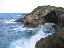
Barceloneta is also famous for its blue sand beaches, due to the high iron content found in the sand.
Government
Barceloneta is known for its political stability. Mayor Sol Luis Fontánes held the mayor's seat for the Popular Democratic Party (PPD) from 1986 until 2012. He assumed the role after the sudden death of elected mayor Héctor Ruíz Martínez, also of the PPD. After that, Fontánes was elected by only a narrow margin (49.2% vs. 48.6%), but he gained popularity with time. At the 2008 general elections, Fontánes received more than 70% of the votes and his margin of victory was one of the biggest of that election.[6][7] However, on 2012, Fontánes was arrested on charges of extortion, after 24 years as mayor. He resigned on March 1, 2012 while in prison.[8] In 2012, Wanda Soler was elected as Fontánes replacement.
The Barceloneta Police Department is the municipal police force in charge of Law Enforcement, which is located on Ave. Escobar.
The city belongs to the Puerto Rico Senatorial district III, which is represented by two Senators. In 2008, José Emilio González and Angel Martínez were elected as District Senators.[9]
Names and symbols
Flag
The flag of Barceloneta is a variation of the flag of Barcelona in Spain, from where the town borrows its name. It features four fields, two of them bearing the cross of Saint George (in Catalan, Sant Jordi), with five red and yellow bars in vertical direction to the right of each cross. These are all symbols pertaining to the city of Barcelona, and the community of Catalonia, where it is located, since the town was founded by a Catalan immigrant. The remaining two fields in the flag are blue, representing the Atlantic Ocean, which lies to the north of Barceloneta.[4][10]
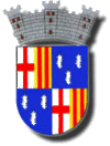
Coat of Arms
Barceloneta's coat of arms is similar to the flag, since it features the same Catalonian symbols. However, it features three sugarcane flowers ("guajanas") on top of the blue fields. The "guajanas" symbolize the source of life of the old agricultural economy of Barceloneta. The blue symbolizes the beaches and marine ports that contributed to the industry and commerce of the town. Like many coat of arms, it features a crown with three towers.
Names
Barceloneta is referred to as La Ciudad de las Piñas (city of the pineapples) due to its plantations of that fruit. It is also known as La Ciudad Industrial (industrial city) for its many industries, most of them pharmaceutical.[11]
Other names are Ciudad de los Indios (town of the Indians) and Pueblo de Sixto Escobar (town of Sixto Escobar) for being the birthplace of the Puerto Rican boxer.
Transportation
Barceloneta has recently added the use of trolly cars free of charge for local transport within the town itself. If you're looking to go further than the town limits, there is a station for "carros publicos" or public car transportation. These work like a kind of taxi and, for a small fee, will take you to the next town, for example, Manati.
See also
References
- ↑ "Barceloneta, Puerto Rico". Areciboweb.50megs.com. Retrieved 2012-02-18.
- ↑ Barceloneta, Puerto Rico on BoricuaOnline
- ↑ Barceloneta, municipio de Puerto Rico on PRfogui
- 1 2 3 Barceloneta, Puerto Rico on BoricuaOnline.com
- ↑ http://welcome.topuertorico.org/maps/barceloneta.pdf
- ↑ Carmen Milagros Díaz (January 15, 2012). "Hablan los alcaldes invencibles". El Vocero.
- ↑ "Elecciones en Puerto Rico". Electionspuertorico.org. Retrieved 2012-02-18.
- ↑ Caquías Cruz, Sandra (March 1, 2012). "Sol Luis Fontanes renuncia a la alcaldía de Barceloneta". El Nuevo Día.
- ↑ Elecciones Generales 2008: Escrutinio General Archived November 20, 2011, at the Wayback Machine. on CEEPUR
- ↑ Barceloneta, municipio de Puerto Rico on PRfrogui
- ↑ http://www.topuertorico.org/city/barce.shtml
External links
- Welcome to Puerto Rico Barceloneta
- BarcelonetaPR.com Spanish website by Santiago A. Villanueva
- electionspuertorico.org