Toa Baja, Puerto Rico
| Toa Baja, Puerto Rico | |||
|---|---|---|---|
| Municipality | |||
| |||
| Nickname(s): "Ciudad de los Valles del Toa", "Ciudad Bajo Aguas", "Los Llaneros" | |||
| Anthem: "Espléndido Toa Baja, jardín de mis amores" | |||
 Location of Toa Baja in Puerto Rico | |||
| Coordinates: 18°26′38″N 66°15′35″W / 18.44389°N 66.25972°WCoordinates: 18°26′38″N 66°15′35″W / 18.44389°N 66.25972°W | |||
| Country | United States | ||
| Territory | Puerto Rico | ||
| Founded | 1745 | ||
| Government | |||
| • Mayor | Aníbal Vega Borges (PNP) | ||
| • Senatorial dist. | 2 - Bayamón | ||
| • Representative dist. | 10 | ||
| Area | |||
| • Total | 41.7 sq mi (108.0 km2) | ||
| • Land | 23.16 sq mi (59.99 km2) | ||
| • Water | 18.54 sq mi (48.01 km2) | ||
| Population (2010) | |||
| • Total | 89,609 | ||
| • Density | 2,100/sq mi (830/km2) | ||
| Demonym(s) | Toabajeños | ||
| Time zone | AST (UTC-4) | ||
| Zip code | 00949, 00950, 00951, 00952 | ||
| Website | toabaja.com | ||

Toa Baja (Spanish pronunciation: [ˈto.a ˈβaxa]) is a municipality of Puerto Rico located in the northern coast, north of Toa Alta and Bayamón; east of Dorado; and west of Cataño. Toa Baja is spread over 5 wards, including Toa Baja Pueblo (The downtown area and the administrative center of the city). It is part of the San Juan-Caguas-Guaynabo Metropolitan Statistical Area.
Toa Baja considered to be a part of the Metropolitan Area. It shares its metropolitan area status with San Juan, Bayamón, Guaynabo, Cataño, Carolina and Trujillo Alto.
Toa Baja is located fifteen minutes by car from San Juan and one hour from Ponce.
History
The region of what is now Toa Baja belonged to the Taíno region of Toa and Bayamón, which was located on the north coast of Puerto Rico.[1] The regions were led by cacique Aramana and Majagua respectively. During the Spanish colonization, a farm was settled in the region around 1511 where Spanish settlers tried to learn from the Taínos how to grow fruits and vegetables. Some of the families that settled in the region were the Marrero, Salgado, and Martínez, which came from the Canary Islands.[2]
In 1745, the town was officially organized, with the parish being built in 1749. It was dedicated to Nuestra Señora de la Concepción (Our Lady of the Immaculate Conception). It is said that in 1776 there were six cattle ranches and 12 sugar cane estates in the region. However, rises in the flow of nearby rivers were problematic for the population. Because of this, in 1841 a group of residents requested the settlement to be transferred to what is now Dorado. The town of Dorado was officially founded the next year.[3]
In 1902, after the U.S. invasion, the Legislative Assembly of Puerto Rico approved the consolidation of several municipalities, which resulted in the annexation of Toa Baja to the city of Bayamón. However, in 1905 the law was annulled, and Toa Baja regained its status as an independent town.[3] In 2010, Toa Baja was among the top ten municipalities in Puerto Rico, in terms of population, with 89,609.[4]
Geography
The town of Toa Baja is located in the Northern Coastal Plains of the island, in the karst zone. It has an area of 62.4 km2 (24.0 miles2). The terrain consists mostly of alluvial deposits and clay-like surface as a result of the surrounding waters.[5]
The elevations range from 60 to 150 meters above sea level, with most of its highest parts located in the south. The rest of the area is mostly plain. The northern part of Toa Baja is characterized for its mangroves and marshes, while the southern part is classified as typical karst area.[5]
Water features
There are three main rivers in Toa Baja: Río la Plata, Río Cocal, and Río Hondo. La Plata is the longest river in the island and crosses Toa Baja in the east. Cocal is the natural boundary between Toa Baja and Dorado.
Cityscape
Barrios
Toa Baja is divided into six barrios.[6]
- Candelaria
- Media Luna
- Palo Seco
- Campanilla
- San Jose
- Toa Baja Pueblo
Controversies
In 2009 an order was given by Governor Luis G. Fortuño to shut off essential services, such as water and electricity, to Villas del Sol, a village within the municipality of Toa Baja. Villas del Sol consists of homes built illegally on flood-prone State land. The Federal Emergency Management Agency bought these homes from the Puerto Rican Government in order to keep them from being used further. In January 2010 the Puerto Rican government began demolishing some of the homes. The village has a large population of Dominicans, both legal and illegal.
Tourism
Landmarks and places of interest
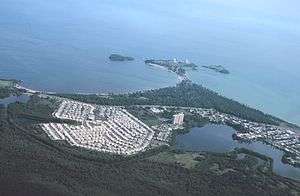
.jpg)
- Cañuelo Fortress
- Central Constancia (sugar mill)
- Isla de Cabras
- Hermana Island
- Nuestra Señora del Carmen Catholic Church
- Palo Seco Thermoelectrical Power Station
- Punta Salinas Beach
- San Pedro Apostle Catholic Church
- Santa Elena Hacienda
- Coliseo Antonio R. Barceló
Culture
Like most municipalities, Toa Baja celebrates its fiestas patronales annually. They begin in June 30 and are dedicated to Saint Peter.[7] There are other festivals celebrated through the year. A Crafts Festival (Feria de Artesanías) is celebrated in March, and a Beach Festival in July.
The Fiestas de la Santa Cruz are celebrated during May, with the participation of various churches and cultural groups. It is dedicated to the Saint Cross, and lasts nine nights. Also, in October, the town celebrates the Festival de la Zafra, with musical groups of bomba and plena.[8]
Sports
Toa Baja doesn't have a team in the island's main male sports leagues. They do have a female volleyball team from the Liga de Voleibol Superior Femenino, the Llaneras de Toa Baja.[9][10]
Each year, Toa Baja hosts both the Pee Wee Reese World Series (for baseball players of ages 12 and under) and the Willie Mays World Series (for baseball players of ages 10 and under). The town has a team, the Llaneros de Levittown, in the PeeWee Reese Category baseball team from the Pro-Deportes/American Amateur Baseball Congress.
Economy
For many years, Toa Baja's economy relied in agriculture, particularly sugar cane and cattle.[11] Because of this, the municipality was the site of many important haciendas like Santa Elena (founded in 1790), Central Constancia (founded in 1867), and Media Luna. In the middle of the 18th Century, fishing also became a primary source of Toa Baja's economy. Cattle ranches were also among the best in the island, processing large amounts of milk. The growth of small fruits also continues to be one of Toa Baja's main products.[12]
After the 1950s, manufacturing started replacing agriculture as the main economic source. Currently, the industrial sector continues to be one of the most important factors of economic growth in the region. Some of the products manufactured in Toa Baja are metal, plastic, concrete, textile, electrical and electronic machinery, and rum.
Demographics
| Racial – (self-defined) Toa Baja, Puerto Rico – 2010 Census[13] | ||
|---|---|---|
| Race | Population | % of Total |
| White | 62,920 | 70.2% |
| Black/African American | 15,074 | 16.8% |
| American Indian and Alaska Native | 522 | 0.6% |
| Asian | 228 | 0.3% |
| Native Hawaiian Pacific Islander | 2 | 0.0% |
| Some other race | 7,787 | 8.7% |
| Two or more races | 3,076 | 3.4% |
Toa Baja currently has a population of 89,609. This represents a decrease of 4,476, from 94,085 in 2000. With the exception of the 2010 census, population in Toa Baja has steadily increased since 1899, when it had 4,030.[14][15]
Government
Anibal Vega Borges, a lawyer, was elected Mayor of the city in 2004 for the first time. He has been re-elected twice (2008 and 2012). Vega Borges' election wins have been for wide margins, which led a newspaper to label him as one of the "most powerful" mayors in the island.[16]
The city belongs to the Puerto Rico Senatorial district II, which is represented by two Senators. Migdalia Padilla and Carmelo Ríos Santiago have served as District Senators since 2005.[17]
Symbols
Flag
Toa Baja's official flag features two vertical bands: the left side is green and the right side is gold. The green band represents the plains of the Toa River (now known as La Plata), and the golden band represents the sun. The green band features two keys, one across the other. One is gold and the other silver, symbolizing the Apostle Saint Peter, the patron saint of the city.[18]
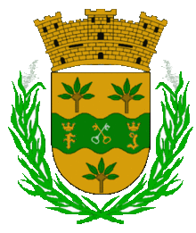
Coat of arms
Toa Baja's coat of arms features a green waving stripe, representing the Toa River, one of the first mentioned in the history of Puerto Rico. Like the flag, it features two keys, one across the other, symbolizing Saint Peter, patron saint of the town. The coat has the letters "F" and "J" to each side of the keys, representing Ferdinand II of Aragon and V of Castile, and his daughter, Joanna of Castile, sovereign of Castile and León.
The gold fields above and below the green stripe represent the wealth of the city. It also feature handfuls of yucca, one of the main crops of this area. It constitutes a symbol of the Taínos who cultivated it, and whose main food was cassava or bread of yucca. Two sugar cane stems surround the shield, representing the cultivation and industry of sugar cane, which was the main source of Toa Baja's economy.
Transportation
Toa Baja is approximately 15 minutes from San Juan by car. The main road to the city is the PR-22 and Road #165.[19]
See also
- List of Puerto Ricans
- History of Puerto Rico
- Did you know-Puerto Rico?
- 2009 Sabana Seca massacre, Sabana Seca area of Toa Baja
References
- ↑ "Gobierno Tribal del Pueblo Jatibonicu Taíno de Puerto Rico". Retrieved January 11, 2015.
- ↑ "Toa Baja, municipio de Puerto Rico". Retrieved January 11, 2015.
- 1 2 "Toa Baja... Ciudad de los Valles del Toa". Proyecto Salón Hogar. Retrieved January 13, 2015.
- ↑ "Población de Puerto Rico por Municipios 2000 y 2010". electionspuertorico.org. March 24, 2011. Retrieved January 15, 2015.
- 1 2 "Geografía de Toa Baja". Retrieved January 13, 2015.
- ↑ http://welcome.topuertorico.org/maps/toabaja.pdf
- ↑ Patron Saint Festivals on Welcome to Puerto Rico
- ↑ "Fiestas y Folclore". ElToa.com. Retrieved January 18, 2015.
- ↑ "Llaneras de Toa Baja". Federación Puertorriqueña de Voleibol. Retrieved January 15, 2015.
- ↑ "Listas las Llaneras para nueva temporada de voleibol superior". El Nuevo Día. January 17, 2012. Retrieved January 15, 2015.
- ↑ "Toa Baja". EdicionesDigitales. Retrieved January 18, 2015.
- ↑ "La Economía". El Toa. Retrieved January 18, 2015.
- ↑ U.S. Census Bureau
- ↑ Población de Puerto Rico por Municipios on CEEPUR
- ↑ Censo 2010 on ElectionsPuertoRico
- ↑ Gómez, Antonio R. (November 15, 2012). "Los alcaldes más poderosos". El Nuevo Día.
- ↑ Elecciones Generales 2008: Escrutinio General on CEEPUR
- ↑ "Escudo y Bandera". ToaBaja.com. Retrieved January 18, 2015.
- ↑ "Toa Baja... Ciudad de los Valles del Toa". Proyecto Salón Hogar. Retrieved January 15, 2015.
Books about Toa Baja
- Los Municipios de Puerto Rico - Toa Baja. Commissioned by the Department of Education in 1992.
- Padilla Melendez, Debra E., Toa Baja: Notas para su historia.
External links
- / Official Web Site Toa Baja
- Toa Baja and its barrios, United States Census Bureau
- City of Toa Baja
- Toa Baja site on Puerto Rico portal