Barley Sheaf, New Jersey
| Barley Sheaf, New Jersey | |
|---|---|
| Unincorporated community | |
|
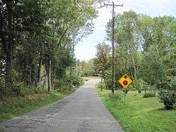
Looking west along Barley Sheaf Road | |
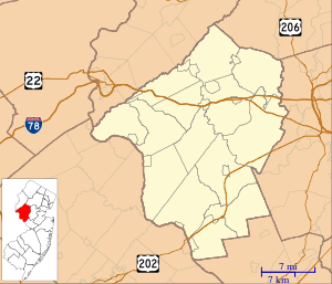 Barley Sheaf, New Jersey  Barley Sheaf, New Jersey  Barley Sheaf, New Jersey Location of Barley Sheaf in Hunterdon County Inset: Location of county within the state of New Jersey | |
| Coordinates: 40°32′45″N 74°49′28″W / 40.54583°N 74.82444°WCoordinates: 40°32′45″N 74°49′28″W / 40.54583°N 74.82444°W | |
| Country |
|
| State |
|
| County | Hunterdon |
| Township | Readington |
| Elevation[1] | 180 ft (50 m) |
| Time zone | Eastern (EST) (UTC-5) |
| • Summer (DST) | EDT (UTC-4) |
| GNIS feature ID | 874498[1] |
Barley Sheaf was an unincorporated community located within Readington Township in Hunterdon County, New Jersey, United States.[2] It was named for the grain once grown in the region. The hamlet was on Barley Sheaf Road between County Route 629 (CR 629) and CR 523. The hamlet at one time housed a general store, a post office, blacksmith, creamery, a hotel and numerous farmsteads.[3] Today only farms remain of the hamlet. The hamlet also carried the names of Farmersville and Campbellsville after Catherine Campbell, who ran the hotel in the area.
References
- 1 2 "Barley Sheaf". Geographic Names Information System. United States Geological Survey.
- ↑ Locality Search, State of New Jersey. Accessed February 28, 2015.
- ↑ Readington Township Historic Preservation. Readington Township: Images of America. Mount Pleasant, SC: Arcadia Publishing, 2008.
This article is issued from Wikipedia - version of the 9/13/2016. The text is available under the Creative Commons Attribution/Share Alike but additional terms may apply for the media files.