Barlow, Pennsylvania
| Barlow, Pennsylvania (Horner's Mill) | |
| Black's Mill | |
| Unincorporated community | |
| Country | United States |
|---|---|
| State | Pennsylvania |
| County | Adams |
| Townships | Cumberland, Mount Joy |
| Survey marker | PENNDoT disc (Rock Cr bridge) |
| - coordinates | 39°45′24″N 77°13′52″W / 39.756682°N 77.231199°WCoordinates: 39°45′24″N 77°13′52″W / 39.756682°N 77.231199°W |
| Post Office | 1890-1911 |
| Timezone | EST (UTC-5) |
| - summer (DST) | EDT (UTC-4) |
| ZIP Code | 17325 |
| Area code | 717 Exchange: 334 |
| GNIS ID | 1203021 [1] |
|
|
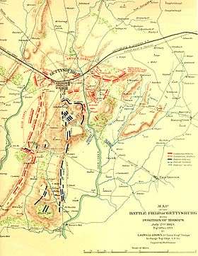
Barlow, Pennsylvania (Horner's Mill during the American Civil War) is a populated place between the Gettysburg Battlefield and the Mason–Dixon line at the intersection of Rock Creek and Pennsylvania Route 134. North of the creek on the road summit is the principal facility of the rural community: the 1939 community hall[2] at the Barlow Volunteer Fire Company fire station. The hall is a Cumberland Township polling place and was used by Mamie & Dwight D. Eisenhower after purchasing their nearby farm (President Eisenhower became an honorary company member in 1955).[3] Horner's Mill was the site of an 1861 Union Civil War encampment,[4] and the covered bridge was used by the II Corps (Union Army) and General George G. Meade en route to the 1863 Battle of Gettysburg.
Barlow is located near the U.S. Route 15 interchange to the north and has 3 Taneytown Rd intersections with the Barlow-Greenmount, Barlow, and Barlow-Two Taverns roads. South of the community is a site listed on the National Register of Historic Places (Spangler-Benner Farm) near the Mount Joy Lutheran Church and cemetery. The neighboring communities of Barlow are Greenmount 2.9 mi to the west, Round Top 3.3 mi to the north, Two Taverns 5.1 mi to the east, Harney MD 3.1 mi to the south, and Fairplay 3.2 miles to the southwest.
| Date | Topic | Event | Coordinates |
|---|---|---|---|
| 1738-03 | Robert Black settled in a disputed Calvert/Penn area[5] of 72 sq mi (190 km2) which in 1740 the "Penn coterie" named "The Manor of Maske".[4] In 1763, the Mason-Dixon survey placed a marker near the confluence of Rock Creek and Marsh Creek, south of the subsequent site for Robert Black's mill. A Black's Cemetery 1760 gravestone identified Robert Black's death[4] (the heirs made a 1792 property claim).[5] In 1762, a Robert Black remained in each of Cumberland and Mt Joy townships.[6] | 39°43′18″N 77°13′15″W / 39.7217°N 77.220728°W | |
| 1787-01 | mill | "Robert Black of Mount Joy Township has built a merchant mill with undershot water wheel on the waters of Rock Creek and wants a road from the mill to John Little's"[7] | 39°45′23″N 77°13′49″W / 39.756505°N 77.230156°W |
| 1799 | mill | The "Henry Black, miller", property assessment was $756[4] after the 1799 death of Robert Black[8] (in 1838, the was Henry's son, Robert Black).[9]:83 | |
| 1808 | PA 134 | The Adams County court approved a road from Gettysburg to Maryland past Black's Mill[10] at the end of the road from Little's.[7] | |
| 1821 | mill | The map symbol (waterwheel) for the "Black" mill on the south bank of "Rock c." was depicted on the west side of the road between Gettysburg and Taneytown.[11] | |
| 1825-06-26 | mill | Flooding carried away part of the dam at Black's Mill,[12] which became George W. Horner's, 1838–49, and Silas Miles Horner's, 1849[9]:83-1890. In June 1826, a Shippensburg wagon team died after being swept from the fording at Black's mill. | 39°45′31″N 77°13′34″W / 39.758672°N 77.226017°W |
| 1828-04-30 | mill | "Black's Mill, Rock Creek" accepted wool for John Arnold[13] and on June 25, 1828, for the Rochdale Wollen [sic] Factory. Later at "Black's Mill, on Rock-creek" on May 6, 1833, wool was accepted for the "Middle-Creek factory". In 1863, "Andre McKinney's, near Black's Mill" collected wool for the Rochdale factory.[14] | |
| 1841 | bridge | John Camp built a covered bridge of two 60-foot spans downstream of the Black's Mill dam for the road between Gettysburg and Taneytown, Maryland.[15] | 39°45′25″N 77°13′53″W / 39.756866°N 77.231441°W |
| 1858 | mill | The "S Horner Saw & Grist Mill" was depicted on a mapped island of Rock Creek near the "N M Horner" and "S M Horner" dwellings.[16] | |
| 1858 | school | Willow Grove school was depicted on the southeast corner of the Taneytown Rd crossing over Plum Run ("Dr. J. Runkle" property)[16] after previously opening upstream along Plum Run "on the Theodore McCallister property", then moving to Lott Road (now Soloman Rd) on the Harry Black farm.[9]:c11 | 39°45′52″N 77°13′55″W / 39.764424°N 77.231848°W |
| 1861-05-06 | Civil War | Captain Stoneman’s four companies of cavalry from Carlisle Barracks encamped at Horner’s Mill[4] | |
| 1863-07-01 | Civil War | General Howard's 2 divisions: "my Third, General Schurz, and my Second, General Steinwehr, in the order named, taking the route by Horner's Mill"[17] to Gettysburg. The detour used a Marsh Creek fording and passed Myer's Mill,[18] Rock Creek Chapel, and Horners Mill; which the Third Division passed at 10:30 a.m.[19] In 1947, an XI Corps marker was placed on the Taneytown Rd's east side south of the Barlow-Greenmount Rd[20] and after the marker had been lost, it was replaced on the west in late July 2008 at the Barlow fire hall. | 39°45′44″N 77°13′57″W / 39.762177°N 77.232382°W |
| 1863-07-01 | Civil War | Winfield Scott Hancock's troops from Taneytown used the nearby fording downstream of Horner's Mill, as well as the covered bridge, to arrive at Gettysburg ~3 pm.[21] | 39°45′14″N 77°13′58″W / 39.753884°N 77.232682°W |
| 1863-07-01 | Civil War | At night, General Meade crossed the Horner's Mill covered bridge en route to Gettysburg[21] after Hancock had returned via Horner's Mill to brief Meade at Taneytown.[22]:29 | |
| 1863-07-02 | Civil War | The II Corps (Union Army) departed from a bivouac near Horner's Mill to arrive at Cemetery Ridge at 7 a.m.[22]:33 | |
| 1863-07-03 | Civil War | General Farnsworth's Union cavalry watered their horses near the Horner's Mill covered bridge prior to Wells' charge on South Cavalry Field. | |
| 1863-07-06 | Civil War | At 4:15 a.m. General Howard at Horner's recommended the XI Corps maneuver to Emmitsburg. | |
| 1863-07-07 | Civil War | The XII Corps (Union Army) left the Gettysburg Battlefield via Horner's Mill on orders to go to Frederick, Maryland, via Taneytown. | |
| 1871-04-18 | bridge | A contract was issued for restoring the Horner's Mill covered bridge to higher piers[15] after it was "swept away by a flood[15]…half a mile" downstream.[23] | |
| 1879 | mill | Bids were solicited for carrying the mail via Horner's Mill[9] between Gettysburg and Harney, Maryland. | |
| 1881-03-03 | The stone home near the mill was sold by Newton M. Horner to J. Gibson Walker, and subsequent transfers were to Charles Hartman (1913), John Adams (1919), John Dietrick (1922), Lloyd Dubbs (1924), Samuel Gault Weaver (1925), and George & Elsie Geiselman (1930).[9]:132 | 39°45′23″N 77°13′43″W / 39.756395°N 77.228479°W | |
| 1885 | store | Josephus Mills opened a general store in part of his home near Horner's Mill[9]:88 (former "S M Horner" dwelling on west of Taneytown Rd/Horner's Mill Rd intersection.).[16] | |
| 1886-02-12 | mill | The Horner's Mill dam breached during a flood and ~165 ft (50 m) of the breast was carried away.[24] | |
| 1887 | PA 134 | The low truss iron bridge over Plum Run was contracted (superstructure contract to Gilbert & Smith foundry, stone work to Nelson Collins).[25] | 39°45′54″N 77°13′55″W / 39.765039°N 77.231998°W |
| 1889-06-06 | bridge | Flooding further damaged the Horner's Mill covered bridge,[9] which had center pier damage from the 1886 flood,[24] but the "Grand Jury refused to approve a bridge". | |
| 1890-12-20 | store | The Barlow Post Office began in the Josephus Mills store[9] with David H. Sterner carrying the mail to/from the Sedgwick Post Office at Round Top.[26] | |
| 1892-08-02 | mill | Silas Mc. Horner offered for sale the "MILL BUILDING, first story of stone and upper stories of frame … adjoining lands of … Josephus Mills and Mills's [sic] store".[27] | |
| 1897[9]:c15 | store | The "smaller house which contained a store operated by Josephus Mills" was replaced by Abner S. Mills, who ran the store in the new house until 1911.[28] The subsequent operator and his wife,[9]:c15 "John W. Black and Emma S. Black", sold the store to "J. Carna Smith" in July 1914 (deeded on March 29, 1915).[29] | 39°45′21″N 77°13′45″W / 39.755802°N 77.229123°W |
| 1900-01-22 | Barlow had a population of ~43 with 10 dwellings plus the school, a steam chopping mill, 2 ice houses, "and an ice cream manufactory … famous for the celebrated Barlow ice cream." The 1828 Rock Creek Chapel (Methodist Episcopal Church)[9]:82 and 1852 Mount Joy Lutheran Church were "both a quarter mile" [sic] from Barlow.[30] | ||
| 1909-05-04 | organization | The Barlow Rural Telephone Company's party line was completed.[31] After 1954 "phantom voices", the group ended in 1957 when replaced by private lines. | |
| 1921-08-24 | organization | The Barlow Community Association's 1st picnic was at the nearby Shriver's Grove.[32] Later annual picnics were held at Benner's Grove south of Barlow (called off c. 1941). | 39°45′47″N 77°14′35″W / 39.763059°N 77.243028°W |
| 1923-04-01 | organization | The Barlow Community Milk Association was formed to consolidate exports from Adams County. | |
| 1923-04-20 | bridge | "Barlow Bridge No. 27"[33] was contracted for concrete to increase the road width to 20 feet from 16.[23] In 1921 the Taneytown Rd from Gettysburg was paved only 3 miles. | |
| 1923-08-30 | bridge | The upstream temporary bridge flooded into the unfinished new bridge, flooding 2 hogs and 20 beehives from the miller's house and floating pies from the kitchen oven.[9]:27 | 39°45′22″N 77°13′48″W / 39.756082°N 77.22996°W |
| 1927 | organization | The Barlow "Pig Club" was formed, and in 1932 the Barlow Home Economics Club organized. | |
| 1929 | school | After having moved to the road's west side,[9][34] Willow Grove school was used for February–April services during Mt. Joy church renovations.[35] | 39°45′51″N 77°13′56″W / 39.764144°N 77.232194°W |
| 1929 | store | James Carnahan Smith closed the "Barlow General Store"[9] (goods auctioned 1939, building rented 1940, sold 1944,[29] & had 1953 fire.)[28] | |
| 1929 | store | Clarence E. "Jumbo" Fair opened a new general store at the Barlow creamery on the creek's north bank, which was later operated by Bill Mellott, Tom Reed (1947–50), John & Ruth Witherow (1955-), Leroy DeGroft (1963), John & Romaine Maring (1964–70, Maring's Grocery), and Homer Brown (1970-1974, Brown's Grocery).[9] | 39°45′26″N 77°13′54″W / 39.757354°N 77.231585°W |
| 1930 | PA 134 | The Taneytown Rd's eastward curve from Rock Creek to the end of Chapel Rd was straightened to an elevated meadow roadbed built using excavation from the hill adjacent to the south.[36] The roadway was moved westward from along the miller's log house and the former Barlow store, bypassing a hill and small run crossing. | 39°45′13″N 77°13′38″W / 39.753519°N 77.227361°W |
| 1931-02-10 | fire co. | The Barlow Volunteer Fire Company organized at Fair's store,[37] where a fire bell alerted volunteer firemen[9]:c20 until a siren became available. The first fire call was to the J. F. Jacobs wash house on April 8,[38] and the company held an ox roast at the Chester Shriver's grove on October 10, 1931.[39] | 39°45′44″N 77°13′56″W / 39.76222°N 77.23222°W[1] |
| 1934 | road | Horner's Mill Rd (now Barlow-Two Taverns Rd, Hoffman Orphanage Rd in 1953) was rerouted by the WPA at Barlow from the hill along the mill's stone farmhouse to the south several yards into the excavated side of the hill along a run, just east of its intersection with the Taneytown Rd between the mill property and the former Barlow store property.[9]:142 | |
| 1934-09 | fire co. | After an equipment demonstration at Rock Creek during the Adams County Fireman's Association meeting, the companies paraded to Benner's Grove. | |
| 1937 | mill | The mill dam was rebuilt slightly upstream by the Adams County Fish and Game Association with help from the WPA, but a fallen tree breached the dam within 2 years.[9]:150 | |
| 1939 | organization | The Barlow 4-H club organized at Horner's school house, and a 1948 committee was formed to name the club ("Barlow Snackers" name created in 1952). | 39°45′17″N 77°12′21″W / 39.754589°N 77.205917°W |
| c. 1940 | organization | The Barlow Baseball Club of the county Junior Baseball League (Southern Pennsylvania Baseball league by 1947) built a field with backstop to the west of the 1939 fire hall. The team made the playoffs in 1941, and in 1943 Chester Shriver Jr. was cited by Wid Matthews of the Brooklyn Dodgers as a post-war prospect. | 39°45′44″N 77°14′02″W / 39.762321°N 77.233983°W |
| 1947 | school | Willow Grove schoolhouse was sold as was the Centennial Hall/Green Bush school.[40] southwest of Barlow[16] on the "Barlow-Natural Dam road"., | |
| 1989[9]:118 | bridge | The wider bridge to replace the 1923 bridge included a PENNDoT survey marker on the top of the south abutment's upstream side. | |
| 2008-08-04 | fire co. | The Barlow fire service area was increased to include a portion of the defunct Kingsdale Fire Company area at Maryland Line Road.[41] | |
| c. 2009 | One of the 10 Barlow dwellings of 1900[34] was demolished at 1998 Taneytown Rd after a fire several years earlier. | ||
| 2011-05-21 | fire co. | The fire company held the first bi-annual community day to replace the former 3-day July carnival.[42] |
References
- 1 2 U.S. Geological Survey Geographic Names Information System: Barlow, Barlow Volunteer Fire Company 22 (2099994, 2006)
- ↑ "$500,000 Being Spent For Spring Building Program in the County" (Google News Archives). The Star and Sentinel. March 18, 1939. Retrieved 2011-05-28.
- ↑ Eisenhower, President Dwight D. (1955), Letter of thanks, The White House, Washington, District of Columbia (cited by Geiselman p. 104)
- 1 2 3 4 5 "Chapter XXX: Cumberland Township". History of Cumberland and Adams Counties, Pennsylvania: Part III, History of Adams County. Chicago: Warner, Beers & Co. 1886. pp. 236–247. Retrieved 2011-04-28.
- 1 2 A List of Names of such Persons as Settled and made Improvements in the Manor of Maske before the 18th day of June 1741, Gettysburg Compiler, January 13, 1876, retrieved 2011-05-28 (This list is cited by the 1886 Adams County History: 'The term “Scotch-Irish of the border” was a name given to these settlers by the colonial land grabbers of the Penn coterie (A. Boyd Hamilton, Harrisburg)."
- ↑ tax roll (Ancestry.com citation), 1762, retrieved 2011-06-02
- 1 2 York County, Pennsylvania court (Adams County was formed in 1800) (January 1787), [court record] --cited by Geiselman p. 83. NOTE: The Little tavern is depicted on the Baltimore Pike at a run (now Little's Run @ Two Taverns, Pennsylvania) on 1821 Small & Wagner map.
- ↑ Black, Robert (May 10, 1799), My Last Will and Testament (Ancestry.com transcription), retrieved 2011-06-02,
Also the use of my Negro woman Lucy. … the land I sometime ago sold and conveyed to them on the North side of Rock Creek and in Cumberland township
(Transcription text does not identify a grist mill, nor land in Mt Joy Township, nor specify land south or east of Rock Creek.) - 1 2 3 4 5 6 7 8 9 10 11 12 13 14 15 16 17 18 19 Geiselman, John P (1996). Cleveland, Linda K., ed. Reflections. Preface: Audrey J. Sanders. Columbus GA: Brentwood Christian Press. Retrieved 2011-06-02. NOTE: Geiselman/Clevelend (1996) entitled Ch. 5 "Spring Flood" for the August event.cited Reflections chaptersCh. 5 "Spring [sic] Flood". pp. 27-.
Ch. 11 "Willow Grove School". pp. 49–52.
Ch. 14 "Rock Chapel". p. 82.
Ch. 15 "Horner's Mill Becomes Barlow". pp. 83–8.
Ch. 19 "The Barlow Fire Company". pp. 101–5.
Ch. 21 "Buying the Barlow Farm". pp. 129–32.
Ch. 23 "The 1930s". pp. 137–154. - ↑ petition for road (approved), Adams County court, January 1808
- ↑ Map of York & Adams Counties (Map). Cartography by D. Small. W. Wagner. 1821. Archived from the original on 27 May 2011. Retrieved 2011-05-28.
- ↑ "High Water in 1824" (Google News Archives). The Star and Sentinel -- also in 1900 Gettysburg Compiler. April 15, 1880. Retrieved 2011-05-28. On Monday, June 26, 1825 a flood … the bridge over Littles run, on the Baltimore turnpike, [was destroyed … Mr. Black's mill dam, on Rock Creek [was] partially carried away. External link in
|newspaper=(help) - ↑ "Wool Carding" (Google News Archive). Adams Sentinel. April 30, 1828. Retrieved 2011-06-03.
- ↑ "[advertisement]". Adams Sentinel. May 16, 1863.
- 1 2 3 "Local History: The Wooden Bridges Built by Adams County" (Google News Archive). Gettysburg Compiler. March 22, 1872. p. 2 (col 6). Retrieved 2011-04-26.
1841.--Contract with John Camp, for a covered bridge of two spans of 60 feet each, across Rock creek, at Horner's mill, on the Taneytown road--dated January 4, 1841; price $2,000. Commissioners, Daniel Diehl, Joseph J. Kuhn and William Douglass. This bridge was swept away by a flood about a year ago, and has since been replaced by another of the same character, on foundations several feet higher.
(see also 1897 article) - 1 2 3 4 Howe map (SimmonsGames.com mapviewer) (Map). 1858. Retrieved 2011-01-26. (depicts "School Ho" on Sentz Rd and near "Smith Shop", a "Sch Ho" on east side of Barlow Rd)
- ↑ Williams, Brig. Gen. S (August 31, 1863). "Report of Maj. Gen. Oliver O. Howard, U.S. Army, Commanding Eleventh Army Corps". Gettysburg Campaign. civilwarhome.com. Archived from the original on 22 May 2008. Retrieved 2008-06-21.
At 8 a.m. orders were received from him directing the corps to march to Gettysburg. The column was at once set in motion, my First Division, General Barlow commanding, following the First Corps by the direct route [Emmitsburg Road]; my Third, General Schurz, and my Second, General Steinwehr, in the order named, taking the route by Horner's Mill.
- ↑ Map of the Battle-field of Gettysburg (Map). Cartography by 1st Lieut L Howell Brown, Army of Northern Virginia, copied by Hoffman. (authenticated/published in War of the Rebellion Atlas. 1891. External link in
|publisher=(help) - ↑ Hartwig, D. Scott. "The 11th Army Corps on July 1, 1863". The Unlucky 11th. gdg.org. Retrieved 2008-06-21.
(Hartwig cites: The War of The Rebellion. A Compilation of The Official Records of the Union and Confederate Armies. Washington: Government Printing Office, 1889, Series 1, Volume 27, Part 1, pp. 701, 727) - ↑ "Gettysburg Campaign: Eleventh Corps". Barlow, Pennsylvania: Pennsylvania Historical and Museum Commission. 2008. Archived from the original (ExplorePAhistory.com webpage) on May 19, 2007. Retrieved 2011-04-30.
The Union Army 11th Corps, crossing from the Emmitsburg Road, July 1, 1863, turned north here toward Gettysburg. The Union 2nd Corps camped here on the night of July 1
. Marker dedicated on December 12, 1947. - 1 2 "Gettysburg Campaign: Gen. George G. Meade" (HMdb.org webpage). Pennsylvania Route 134 near Mason–Dixon line (39° 43.772′ N, 77° 12.632′ W): Pennsylvania Historical and Museum Commission. 1947. Retrieved 2011-04-30.
Gen. George G. Meade, who had replaced Hooker as Union commander, June 28, 1863, traveled this road from Taneytown to Gettysburg the night of July 1. He made his headquarters just south of Gettysburg. … In addition to Meade, the Federal II Corps used the Taneytown Road to reach Gettysburg. Upon hearing of the death of General John Reynolds on July 1, 1863 at Gettysburg, General Meade dispatched the II Corps commander, General Winfield S. Hancock, to take charge at Gettysburg. Hancock traveled the thirteen miles from Taneytown to Gettysburg, arriving at around 3 p.m. that day.
(HMdb contributor Craig Swain) - 1 2 Final Report on the Battlefield of Gettysburg (Google Books) (Report). pp. 28, 33. Retrieved 2011-05-31.
General Slocum, who had been superintending the movements of Williams' Division at Rock Creek, having now arrived at Cemetery Hill, Hancock transferred the command to him about six o'clock, and then returned to Taneytown where he reported in person to the general commanding.:29 … The Second Corps -- General Hancock's -- having bivouaced on the Taneytown Road, about three miles in the rear, moved up and went into position at 7 a.m., on Cemetery Ridge
:33 - 1 2 "Will Ask For Two County Bridges" (Google News Archive). Gettysburg Times. Times and News Publishing Company. April 4, 1923. Retrieved 2011-04-28.
The present structure at Barlow is a girder bridge of two fifty-five foot spans. It was built more than 70 years ago, according to the Commissioners. At one time 52 years ago, the structure was washed away from its moorings and carried on a much-swollen Rock Creek for a distance of half a mile. It was brought back; a few additions were made and only slight repairs have been made since that time. The bridge now has a roadway 16 feet wide. This is to be increased to 20 feet and all abutments and piles are to be reinforced with concrete
- 1 2 "Dam Broken" (Google News Archive). Gettysburg Compiler. February 16, 1886. p. 3 (col 2). Retrieved 2011-04-26.
We hear that Horner's Dam, on Rock creek, five miles south of Gettysburg, was broken on Friday night,[February 12] and about 165 feet of the breast carried away. The new county bridge (occupying the place of one destroyed by a similar flood a few years ago) escaped without damage except a slight break in the pier supporting the centre. Mr. Henry Schriver lost 150 panels of post and rail fence along the creek by the heavy ice floating against it, and some of the roads were blocked.
- ↑ "Contracts Awarded" (Google News Archives). Gettysburg Compiler. July 5, 1887. Retrieved 2011-05-28.
The County Commissioneres on Thursday awarded the following contracts: …to Gilbert & Smith … For the superstructure of a low truss iron bridge on Plum Run, on the Gettysburg and Taneytown road,…the stone work to Nelson Collins … The building at the Alms House was awarded John F. Socks … Mr. Jacob Hoke, author of "The Great Invasion," has also gotten up "A Guide to the Battlefield of Gettysburg, with Illustrations and Maps,"
- ↑ "Barlow Items" (Google News Archive). The Star and Sentinel. January 20, 1891. Retrieved 2011-04-27.
- ↑ Horner, Silas Mc. (August 2, 1892). "Administrator's Sale of Valuable Real Estate" (Google News Archive). Gettysburg Compiler. Retrieved 2011-04-28. NOTE: Silas Mc. Horner sold the tract to Theodore McCallister on December 24, 1892, who along with his wife Mary C. McCallister sold it 2 days later to Josephus Mills, and Mills' heirs sold it to widower Calvin Heagy on November 4, 1914.Deed 4898
- 1 2 "2 Departments Battle Barlow Fire Saturday" (Google News Archive). Gettysburg Compiler. February 21, 1953. Retrieved 2011-05-29.
The house was built about 50 years ago on the site of a smaller house which contained a store operated by Josephus Mills. A son, Abner S. Mills, who later operated a store in Gettysburg, erected the building, and conducted a store in it until about 1911, when it was taken over by John Black. Mr. Black had a store there for four years.
- 1 2 Property Deed Books, Gettysburg, Pennsylvania: Adams County Courthouse
Deed 2420 "John W. Black and his wife Emma S. Black" (March 29, 1915). Deed to "J. Carna Smith". Deed Book #104, p. 295.
Deed 4898 "C. R. Fissel and Clara B. Fissel" (September 4, 1927). Deed to Harry Heintzelman. Deed Book #116, p. 29 (recorded "August 31, 1927").
Deed 6686 "Clarence C. Smith and Elsie B. Smith Geiselman" (May 6, 1944). Deed to George A. Mummert and Verna E. Mummert. Deed Book #165, p. 371. - ↑ Sharetts, John F--"J. F. S." (January 22, 1900). "Barlow Items" (Google News Archives). Gettysburg Compiler. p. 3 col. 6. Retrieved 2011-04-28.
David Maring slaughtered a porker that weighed 471. January 17 an enjoyable social met at the home of Harry J. Schriver and wife in honor of a couple latey [sic] married, Andrew Clouser and Miss Kate Williams, both of New Kingston, Pa. … Those present were: … A. S. Mills and family, Horner Hill and family, of Harney, Mrs John F. Sharetts and David Lott. … road leading from Two Taverns to Horner's Mill.
(map without creamery) - ↑ "Barlow" (Google News Archive). Gettysburg Times. Times and News Publishing Company. May 4, 1909. Retrieved 2011-04-27. (1914 telephone officers) Geiselman p. 86-7: "…a six-party line, the subscribers were William G. Durboraw, Sentman Schriver, Franklin Cromer, David Maring, William Cromer, and terminated in the Abner S. Mills store. Each had to pay fifty dollars…" Lloyd Durboraw sold his Barlow phone stock in 1944.
- ↑ "Seven Hundred at Barlow Picnic" (Google News Archives). The Star and Sentinel. August 27, 1921. Retrieved 2011-04-29.
- ↑ Barlow bridge plaque, formerly embedded in concrete bridge wall, 1923 (image at Geiselman p. 118)
- 1 2 [topographic map] (Map). c. 1900. Retrieved 2011-05-28.
- ↑ Lohr, Margaret (née Benner) (1990), Mt. Joy Lutheran Church: 1890-1990, Biglerville, Pennsylvania: Osborne Printing Company, p. 23
- ↑ "York Company Gets $185,816 Road Contract" (Google News Archive). New Oxford Item. February 13, 1930. Retrieved 2011-05-28. NOTE: Lohr (1990, p. 37)--> claims the Taneytown Rd construction was 1929.
- ↑ "Organize New Barlow Group" (Google News Archives). Gettysburg Times. February 11, 1931. Retrieved 2011-05-28.
- ↑ "Barlow Firemen Fight First Fire" (Google News Archives). The Star and Sentinel. April 11, 1931. Retrieved 2011-05-28.
- ↑ "Ox Roast" (Google News Archives). Gettysburg Times. October 5, 1931. Retrieved 2011-05-28.
- ↑ Minnick, Rev W.G. (1905), History of Mt. Joy. Church,
On September 7th services were held in Green Bush school house (now Centenniel Hall). (published in Lohr 1990 p. 3-5).
- ↑ Young, Aaron (August 6, 2008). "Fire company won't call it quits". GettysburgTimes.com. Retrieved 2011-05-28.
- ↑ "Community Day: Barlow Fire Company" (publicity flyer). Retrieved 2011-05-27.
Municipalities and communities of Adams County, Pennsylvania, United States | ||
|---|---|---|
| Boroughs | 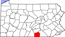 | |
| Townships | ||
| CDPs | ||
| Unincorporated communities | ||
| Ghost town | ||