Barrow Island (Western Australia)
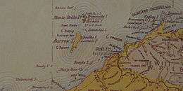 Barrow Island from an 1897 map, showing the Australian mainland on the bottom right (south-east) and the Montebello Islands to the north | |
 Barrow Island Barrow Island (Western Australia) | |
| Geography | |
|---|---|
| Location | Indian Ocean, off the Pilbara coast of Western Australia |
| Coordinates | 20°47′53″S 115°24′22″E / 20.798°S 115.406°E[1]Coordinates: 20°47′53″S 115°24′22″E / 20.798°S 115.406°E[2] |
| Area | 202 km2 (78 sq mi) |
| Length | 27 km (16.8 mi) |
| Width | 11.5 km (7.15 mi) |
| Coastline | 72 km (44.7 mi) |
| Administration | |
|
Australia | |
| State | Western Australia |
Barrow Island is a 202 km2 (78 sq mi) island 50 kilometres (31 mi) northwest off the Pilbara coast of Western Australia. The island is the second largest in Western Australia after Dirk Hartog Island.[3]
Discovery and early history
Navigators had noted its existence since the early 17th century, and Nicholas Baudin sighted it in 1803, mistakenly believing it to be part of mainland Australia.[4] Phillip Parker King named the island in 1816 after Sir John Barrow, a Secretary of the Admiralty and founder of the Royal Geographical Society.
The island was visited by indigenous Australians before and after its separation from the mainland, approximately 8000 years ago.[5] Stone artefacts including several weathered flakes and fragments made of igneous and metamorphic rocks and chert were collected from Barrow Island in the 1960s.[5] Thevenard Island also has evidence of Aboriginal visitation,[5] and it is likely that the nearby Montebello Islands were utilized as well, however there have been no archaeological finds from these islands.
Whalers were known to operate in the area from about 1800 onwards. The first recorded visit by whalers was in //$ with continued visits occurring until 1864. The island was used as a slave trading centre for Aborigines during the 1870s by Captain William Cadell until he was arrested and removed from the colony in 1876. Slave labour was used in the nearby mainland pearling industry.[6]
Guano was found on the island and mining began in 1883. It was mined for the remainder of the 1880s and sold to markets in Perth.[7]
Environment

Barrow Island is noted for its flat spinifex grasslands spotted with termite mounds. While the main feature of Barrow Island’s geography is the undulating limestone uplands, the island is surrounded by a mixture of sandy beaches and rocky shores, low cliffs, dunes, salt flats, and reefs.
Due to its isolation from mainland Australia and protection afforded under its statutory status, Barrow Island is one of the most important conservation reserves in Western Australia.[8] It is an "A-class" reserve, the highest level of conservation protection available for Crown land in Australia.[9] Once a national park or class A nature reserve is made, mining leases and general purpose leases cannot be granted over them without the consent of both Houses of Parliament, and actual mining cannot take place within them without specific permission of the Minister for Environment. This occurred in 2003, when a portion of the reserve was excised in order to facilitate the Gorgon gas development program [10]
The island is known for its diversity of mammalian fauna, including several species now extinct or greatly reduced on mainland Australia. 13 mammal species exist on the island, including the spectacled hare-wallaby, burrowing bettong (or boodie), golden bandicoot, black-flanked rock-wallaby, Barrow Island euro and Barrow Island mouse (Pseudomys nanus ferculinus).[11] The island is also home to 43 species of terrestrial reptiles including a variety of dragons, legless lizards, geckos, skinks, snakes and monitors.[11] The most recognisable of these is probably the perentie, Australia's biggest lizard and the island's top predator. The island represents important turtle nesting habitat for the green turtle and flatback sea turtle.
Some exotic species exist on the island (e.g. the American cockroach[12]) but the island fauna is largely intact. Black rats (Rattus rattus) were discovered to have established in 1990, but were eradicated by the Department of Parks and Wildlife (then CALM).[13] Current threats include invasive species (including weeds, feral cats, common house gecko, etc.) establishing on the island, clearing for development, fire and disease.
Limestone caves on Barrow Island support subterranean ecological communities. These include endemic and vulnerable species. Invertebrate species include Stygofauna, amphipod crustaceans, of Nedsia, Liagoceradocus and other genera. These mostly inhabit an anchialine system, a 'lens' of fresh water above the saline ground water, which they share with species such as Milyeringa veritas—the Blind gudgeon. Troglofauna have also been discovered within the cave systems; these include the schizomid Draculoides bramstokeri and perhaps the only troglobitic reptile—Ramphotyphlops longissimus. Hydrogen sulphide produced by the "Barrow fault" may sustain this diverse community through chemoautotrophic energy production.[14]
During Cyclone Olivia in 1996, Barrow Island experienced the strongest wind gust in recorded history, at 408 kilometres (254 mi) per hour.[15] [16]
Birds
Barrow Island has been classified by BirdLife International as an Important Bird Area. Birds include the Barrow Island black-and-white fairy-wren (Malurus leucopterus edouardi), an endemic subspecies of the white-winged fairy-wren which is regarded as vulnerable to extinction.[17] The island also supports over 1% of the world populations of grey-tailed tattler, red-necked stint, pied oystercatcher, and fairy tern, as well as an isolated population of the spinifexbird.[18]
Conservation
The Western Shield project has sought to reduce the impact of introduced species to the region. Corporate and state government cooperation on programs has produced studies into the little-known subterranean fauna of the island.
Energy reserves
Oil
Oil was discovered on the island in commercial quantities in 1964 by West Australian Petroleum Pty Ltd (WAPET), and the first oil field was established shortly after.[19] In 1995, there were 430 wells producing oil and natural gas across most of the southern half of the island.[20] The site has been Australia's leading producer of oil.
Oil tankers are filled by a submarine pipeline that extends 10 km offshore. WAPET established a 200-room apartment complex for workers on the island.[21] A private airport facility known as Barrow Island Airport (IATA: BWB, ICAO: YBWX) was also established to transport workers and equipment from Karratha and Perth.
Gas
In December 2009, a development consortium between the Australian subsidiaries of Chevron, ExxonMobil, and Shell received environmental approvals from the Government of Western Australia to develop natural gas reserves 60 km north of the island. Known as the Gorgon gas project, it is currently under construction (Jan 2012) and will become Australia's largest resource project, mining 40 trillion cubic feet (1,100 km3) of gas from about early 2015.[22]
Climate
| Climate data for Barrow Island Airport, 1999-2013 | |||||||||||||
|---|---|---|---|---|---|---|---|---|---|---|---|---|---|
| Month | Jan | Feb | Mar | Apr | May | Jun | Jul | Aug | Sep | Oct | Nov | Dec | Year |
| Average high °C (°F) | 33.3 (91.9) |
33.4 (92.1) |
33.1 (91.6) |
31.1 (88) |
27.5 (81.5) |
24.2 (75.6) |
23.7 (74.7) |
25.1 (77.2) |
26.7 (80.1) |
29.3 (84.7) |
30.4 (86.7) |
32.0 (89.6) |
29.1 (84.4) |
| Average low °C (°F) | 26.0 (78.8) |
26.2 (79.2) |
26.5 (79.7) |
24.5 (76.1) |
21.2 (70.2) |
18.6 (65.5) |
17.5 (63.5) |
17.8 (64) |
19.3 (66.7) |
21.6 (70.9) |
22.8 (73) |
24.3 (75.7) |
22.2 (72) |
| Average precipitation mm (inches) | 24.8 (0.976) |
57.1 (2.248) |
56.4 (2.22) |
41.8 (1.646) |
55.4 (2.181) |
38.8 (1.528) |
12.8 (0.504) |
3.0 (0.118) |
0.8 (0.031) |
2.5 (0.098) |
2.0 (0.079) |
6.6 (0.26) |
308.7 (12.154) |
| Average rainy days (≥ 1 mm) | 2.1 | 2.5 | 2.6 | 1.4 | 2.3 | 1.9 | 1.1 | 0.5 | 0.1 | 0.1 | 0.1 | 0.4 | 15.1 |
| Source: Australian Bureau of Meteorology | |||||||||||||
Highest wind record
The World Meteorological Organization established Barrow Island as the location of the highest non-tornado related wind gust at 408 km/h (253 mph).[23] The gust occurred on 10 April 1996, during Severe Tropical Cyclone Olivia and is documented in the Australian Meteorological and Oceanographic Journal.[24] The previous record was a 372 km/h (231 mph) gust at Mount Washington, New Hampshire, USA in April 1934.[23]
See also
- Islands of Perth, Western Australia
- List of islands of Australia
- Petroleum industry in Western Australia
References
- ↑ "Barrow Island, Western Australia (Towns & Localities)". Gazetteer of Australia online. Geoscience Australia, Australian Government. Retrieved 28 December 2009.
- ↑ "Barrow Island, Western Australia (Towns & Localities)". Gazetteer of Australia online. Geoscience Australia, Australian Government. Retrieved 28 December 2009.
- ↑ "Landgate - Interesting facts about Western Australia". 2009. Archived from the original on 12 April 2009. Retrieved 2009-04-24.
- ↑ "Barrow Island". gorgon.com.au. Retrieved 2006-12-13.
- 1 2 3 Dortch, C; Morse (1984). "Prehistoric stone artefacts on some offshore islands in Western Australia". Australian Archaeology: 31–47.
- ↑ "M0 w00orowa Historical Society - Ghosttowns of Western Australia" (PDF). 2000. Retrieved 2010-11-07.
- ↑ "The West Australian". 1888. Retrieved 2010-11-07.
- ↑ "10-year plan for Pilbara islands released". 24 February 2015. Retrieved 15 December 2015.
- ↑ "Conservation Reserves" (PDF).
- ↑ "Barrow Island Bill 2003". Parliament of Western Australia.
- 1 2 "Technical Appendix C2: mammals and reptiles" (PDF).
- ↑ Callan, Shae K; Jonathan D Majer; Karl Edwards; Dorian Moro (2011). "Documenting the terrestrial invertebrate fauna of Barrow Island, Western Australia". Australian Journal of Entomology. 50 (4): 323–343. doi:10.1111/j.1440-6055.2011.00818.x.
- ↑ Morris, Keith (2002). Veitch; Norman; Clout, eds. Turning the Tide: the eradication of Invasive Species. IUCN. pp. 219–225.
- ↑ Burbidge, Andrew A (2004). "4, 5, 8, 9.". Threatened animals of Western Australia. Department of Conservation and Land Management. ISBN 0-7307-5549-5.
Threats: The production of oil since the 1960s has resulted in considerable pollution of the ground water ... effect this pollution has had, if any, is not known.
- ↑ Ramer, Holly. "231-mph NH wind gust is no longer world's fastest". Associated Press. Archived from the original on 29 January 2010. Retrieved 2010-01-26.
- ↑ Josh Fisher. (28 January 2010). Australia blows away world record. Wratherzone.
- ↑ "Technical Appendix C3: Avifauna" (PDF).
- ↑ "IBA: Barrow Island". Birdata. Birds Australia. Retrieved 2011-05-19.
- ↑ "Technology in Australia 1788-1988: North West Shelf". Australian Science and Technology Heritage Centre. Retrieved 2007-10-12.
- ↑ Mitch Reardon. The Good Oil on Conservation in Australian Geographic. #37, Jan - Mar 1995. p. 94
- ↑ "Satellite image of workers housing complex". Wikimapia. Archived from the original on 14 December 2006. Retrieved 2006-12-14.
- ↑ "Gorgon Project". gorgon.com.au. Retrieved 2014-07-10.
- 1 2 World Record Wind Gust: 408 km/h. World Meteorological Organization.
- ↑ Courtney et. al. 2012, Documentation and verification of the world extreme wind gust record: 113.3 m/s on Barrow Island, Australia, during passage of tropical cyclone Olivia, AMOJ 62,p1-9.
Further reading
- Butler, Harry, (1982) Barrow Island (written by Harry Butler and compiled by Jacqueline Cox with assistance of other Wapet staff). Perth, W.A : West Australian Petroleum Pty Ltd.