Barta'a
| Barta'a برطعة | |
|---|---|
| Town | |
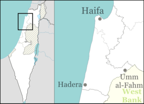 Barta'a Approx. location within the Palestinian territories/Israel | |
| Coordinates: 32°28′28″N 35°05′32″E / 32.47444°N 35.09222°ECoordinates: 32°28′28″N 35°05′32″E / 32.47444°N 35.09222°E | |
| Territory | Palestinian territories/Israel |
| Governorate/District | Jenin/Haifa |
| Area | |
| • Total | 4,320 dunams (4.3 km2 or 1.7 sq mi) |
| Population (2006) | |
| • Total | 8,300 |
| Time zone | IST (UTC+2) |
| • Summer (DST) | IDT (UTC+3) |
Barta'a (Arabic: برطعة, Hebrew: בַּרְטַּעָה) [meaning: "cutting"[1]) is a town in Israel and the Palestinian territories that straddles both sides of the Green Line and the Wadi Ara region.
Western Barta'a is in the Haifa District of Israel, and forms part of the Basma local council. Its 4,700 residents are Arab citizens of Israel.[2]
Eastern Barta'a is in the Palestinian territories in the northern part of the Jenin Governorate of the West Bank in what was designated under the Oslo Accords Area C. It has 3,600 residents, of whom 30-40 percent carry Israeli identity cards and the rest of whom carry Palestinian identity cards.[2][3][4]
History
In 1882, during Ottoman rule, the Palestine Exploration Fund's Survey of Western Palestine described it as "a ruined Arabic village on a high hill, with a spring in the valley to the north 400 feet below."[5]
In the 1922 census of Palestine, conducted by the British Mandate authorities, Barta'a had a population of 468, all Muslim,[6] increasing in the 1931 census to 692, still all Muslims, in 94 houses.[7]
In 1945 Barta'a (including Khirbat Tura el Gharbiya) had a population of 1,000 Muslims[8] with 20,499 dunams of land, according to an official land and population survey.[9] 464 dunams were used for plantations and irrigable land, 1,957 dunams for cereals,[10] while 1,900 dunams were non-cultivable land.[11]
Separation, reunification and separation
After the 1948 Arab-Israeli War, the village of Barta'a was divided by the 1949 armistice into eastern and western parts. The western part fell under Israeli control, while the eastern part fell under Jordanian control. From 1949 to 1967, travel between the two halves was practically impossible.
Following the 1967 Six-Day War, Israel took control of the West Bank and the two parts of the town were informally reunited, operating as one municipal unit. Since most of the residents in both parts of the town belong to the same extended family, the de facto "reunification" was viewed positively by town residents.[2]
Barta'a enclave
After the 2003 construction of the Israeli West Bank barrier, Eastern Barta'a found itself located in a closed military zone, an area between the Green Line and the barrier known as the Seam Zone.[12]
The United Nations Relief and Works Agency (UNRWA) has noted that since the building of the separation barrier, Eastern Barta'a is part of a totally enclosed enclave with two restricted entry/exit gates to rest of the West Bank: Barta'a and Shaked.[13] Since the introduction of the seam zone gate and permit system in October 2003, inhabitants of the Barta'a enclave have been designated "long-term residents" and must have a permit to live in and to enter and leave the enclave.[14] Every person who wants to enter the enclave must also apply for a permit.[13]
Eastern Barta'a (Barta'a ash-Sharqiyya) is the largest town in the Barta'a enclave which also includes the Palestinian villages of Um ar-Rehan, Khirbet 'Abdallah al-Yunis, Khirbet Ash-Sheikh Sa'eed, Khirbet al-Muntar al-Gharbiya, Khirbet al-Muntar ash-Sharqiyya, and Dhaher al-Malik.[15] There are no checkpoints to the west, but "long-term residents" of the Barta'a enclave, most of whom do not have Israeli citizenship, face fines if they leave the enclave to venture into Israel.[15]
Shaked gate is only open for a few minutes in the morning and at lunchtime, allowing children from the villages of Daher al-Mahler and Um ar-Rehan to school in a nearby village. All those over age 12 over must have a permit to pass through the Shaked gate.[14]
UNRWA reported in October 2005 that its
"relief and other humanitarian efforts have been no exception to IDF restrictions. Since the completion of the wall/fence in the Barta’a area, UNRWA staff members have faced delays, abuse and intimidation at the gates of the enclave on a number of occasions. Since 1 October, access for UNRWA’s staff members has been denied for lack of permit to be inside the enclave, designated 'seam zone' by the Israeli government. The official reason being that after the gate, there are no more checkpoints before entering Israel. Thus the enclave is effectively de facto annexed to Israel a fact not lost on Israeli Defense Force soldiers who consistently refer to the enclave as 'Israel'."[15]
In 2005, a new Israeli Defense Force District Coordinators Office opened within a new gate complex at Barta'a. According to UNRWA, it appears to be permanent infrastructure, including metal detectors and shelters.[15]
For non-'long term residents', access through the Shaked gate has become more and more restricted. UNRWA cites the examples of women from Barta'a who have married and live outside the enclave are not able to visit their families there and workers who live east of the fence in the West Bank who are unable to get into the enclave to work.[15]
Meanwhile, the market on the eastern side has become a hotspot for customers from Israel. Because the residents do not live under Israeli social system, products are cheaper than in Israel. The area is accessible for Palestinians and Israelis, and thus has become a kind of free-trade zone.[16]
See also
References
- ↑ Palmer, 1881, p. 144
- 1 2 3 Vered Lee (2007-02-19). "There's no EKG - but there is reflexology". Archived from the original on 12 May 2007. Retrieved 11 May 2007.
- ↑ Projected Mid -Year Population for Jenin Governorate by Locality 2004- 2006 Palestinian Central Bureau of Statistics
- ↑ "Military orders to demolish 72 commercial shops and houses in East Barta'a". Applied Research Institute-Jerusalem (ARIJ). 2003-01-21. Retrieved 11 May 2007.
- ↑ Conder and Kitchener, SWP II, p. 51
- ↑ Barron, 1923, Table IX, Sub-district of Jenin, p. 30
- ↑ Mills, 1932, p. 67
- ↑ Department of Statistics, 1945, p. 16
- ↑ Government of Palestine, Department of Statistics. Village Statistics, April, 1945. Quoted in Hadawi, 1970, p. 54
- ↑ Government of Palestine, Department of Statistics. Village Statistics, April, 1945. Quoted in Hadawi, 1970, p. 98
- ↑ Government of Palestine, Department of Statistics. Village Statistics, April, 1945. Quoted in Hadawi, 1970, p. 148
- ↑ Margarat Evans (2006-01-06). "Indepth Middle East:Israel's Barrier". CBC. Archived from the original on 18 May 2007. Retrieved 11 May 2007.
- 1 2 "UNRWA Profile: Barta'a Sharqiya Enclave". UNRWA. June 2005.
- 1 2 Operations Support Officer Programme (2005-02-14). "Case Study:UNRWA's access to Barta'a enclave disrupted by IDF restrictions" (PDF). UNRWA. Retrieved 11 May 2007.
- 1 2 3 4 5 Operations Support Officer Programme West Bank (2005-02-14). "Case Study: UNRWA's access to Barta'a enclave disrupted by IDF restrictions" (PDF). UNRWA. Retrieved 2007-08-28.
- ↑ Arab town, both Israeli and Palestinian, divided by shopping, Haaretz on 1. February 2012
Bibliography
| Wikimedia Commons has media related to Barta'a. |
- Barron, J. B., ed. (1923). Palestine: Report and General Abstracts of the Census of 1922. Government of Palestine.
- Conder, Claude Reignier; Kitchener, H. H. (1882). The Survey of Western Palestine: Memoirs of the Topography, Orography, Hydrography, and Archaeology. 2. London: Committee of the Palestine Exploration Fund.
- Department of Statistics (1945). Village Statistics, April, 1945. Government of Palestine.
- Hadawi, Sami (1970). Village Statistics of 1945: A Classification of Land and Area ownership in Palestine. Palestine Liberation Organization Research Center.
- Mills, E., ed. (1932). Census of Palestine 1931. Population of Villages, Towns and Administrative Areas (PDF). Jerusalem: Government of Palestine.
- Palmer, E. H. (1881). The Survey of Western Palestine: Arabic and English Name Lists Collected During the Survey by Lieutenants Conder and Kitchener, R. E. Transliterated and Explained by E.H. Palmer. Committee of the Palestine Exploration Fund.
External links
- Welcome To Barta'a
- Survey of Western Palestine, Map 8: IAA, Wikimedia commons
- UNRWA Profile of Barta'a Sharqiya Enclave
- Salon article on Barta'a entitled, "Another Brick in the Wall"
- Town on Israeli-Palestinian border finds a good balance, Inexpensive goods on the West Bank side of Barta’a attract many Israelis for shopping, By Linda Gradstein February 17, 2012. "In Barta’a, Israelis and Palestinians mix freely. The town is legally divided, with West Barta’a inside Israel and East Barta’a in the West Bank. But there’s no physical barrier between the two sides, and East Barta’a has developed a thriving market of hundreds of small stores selling everything from coffee sets to sheets to food to special teddy bears for Valentines Day."
- Google map
| Cities |  | |
|---|---|---|
| Municipalities |
| |
| Villages |
| |