Batemans Bay (New South Wales)
| Batemans Bay | |
|---|---|
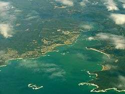 Aerial photo, looking west, 2008. | |
| Location | South Coast, New South Wales |
| Coordinates | 35°44′S 150°13′E / 35.733°S 150.217°ECoordinates: 35°44′S 150°13′E / 35.733°S 150.217°E |
| Type | Bay |
| Primary inflows | Clyde River |
| Primary outflows | Tasman Sea, South Pacific Ocean |
| Catchment area | 28 km2 (11 sq mi) |
| Basin countries | Australia |
| Surface area | 34.5 km2 (13.3 sq mi) |
| Average depth | 11.1 m (36 ft) |
| Water volume | 383,484 megalitres (13,542.6×106 cu ft) |
| Frozen | never |
| Islands | Snapper Island, Tollgate Islands |
| Settlements | Batemans Bay |
| References | [1] |
Batemans Bay is an open oceanic embayment that is located in the South Coast region of New South Wales, Australia. The bay forms the mouth of the Clyde River and its primary outflow is to the Tasman Sea of the South Pacific Ocean.
Location and features
Batemans Bay is fed by the Clyde River and its tributaries, drawing its catchment from the eastern slopes of the Budawang Range and the Great Dividing Range from within the Budawang, Clyde River, Bimberamala, and Monga national parks.[2][3] Cullendulla Creek also flows into Batemans Bay, between the townships of Surfside and Longbeach, west of Square Head.[4]
The total catchment area of the bay is approximately 28 square kilometres (11 sq mi) and the bay holds an estimated 383,484 megalitres (13,542.6×106 cu ft) of water at an average depth of 11.1 metres (36 ft). The surface area of the bay comprises 34.5 square kilometres (13.3 sq mi)[1] and generally stretches from the confluence of the Clyde River with the bay east of the town of Batemans Bay, near Snapper Island; to its mouth with the Tasman Sea at the Tollgate Islands, located between North Head and Circuit Beach.
History
The traditional custodians of the land surrounding Batemans Bay are the Indigenous Australian Yuin people of the Walbunja clan. A number of sites surrounding the bay are considered culturally significant to the Aboriginal peoples.[4]
On 22 April 1770, European explorer, Captain James Cook first sighted the bay when navigating his way around Australia on his ship, HMS Endeavour. Cook may have named the bay in honour of Nathaniel Bateman; the captain of HMS Northumberland at the time when Cook was serving as her master from 1760-62.[3][5] Alternatively, the name was chosen in honour of John Bateman, 2nd Viscount Bateman, a former Lord Commissioner of the Admiralty in the 1750s.[6]
See also
References
- 1 2 "Batemans Bay: Physical characteristics". Coastal and floodplain management: Coastal zone management: Estuaries of NSW. NSW Environment & Heritage. 26 April 2012. Retrieved 25 May 2013.
- ↑ "Map of Batemans Bay, NSW". Bonzle Digital Atlas of Australia. 2013. Retrieved 25 May 2013.
- 1 2 "Batemans Bay". Geographical Names Register (GNR) of NSW. Geographical Names Board of New South Wales. Retrieved 25 May 2013.
- 1 2 "Hanging Rock Catalina" (PDF). Preliminary Public Aboriginal Heritage Inventory. Eurobodalla Shire Council. April 2009. Retrieved 25 May 2013.
- ↑ Moore, Dennis (2002). "The Inlet That Eluded Bass, Batemans Bay - South Coast NSW". Morningside Internet. Retrieved 25 May 2013.
- ↑ Robson, John (2009). Captain Cook's War and Peace. University of New South Wales Press. p. 107. ISBN 9781742231099.

| North of Sydney Harbour |
|
|---|---|
| Within Sydney Harbour | |
| South of Sydney Harbour | |
| |