Mystery Bay, New South Wales
| Mystery Bay New South Wales | |
|---|---|
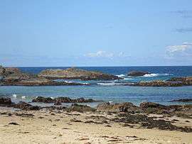 A beach at Mystery Bay | |
|
Mystery Bay | |
| Coordinates | 36°18′13″S 150°07′49″E / 36.30361°S 150.13028°ECoordinates: 36°18′13″S 150°07′49″E / 36.30361°S 150.13028°E |
| Population | 248 (2011 census)[1] |
| Postcode(s) | 2546 |
| LGA(s) | Eurobodalla Shire |
| State electorate(s) | Bega |
| Federal Division(s) | Eden-Monaro |
Mystery Bay is a small town on the south coast of New South Wales, Australia. Mystery Bay is halfway between Central Tilba and Narooma, two kilometres off the Princes Highway on Mystery Bay Road. At the 2011 census, Mystery Bay had a population of 248 people.[1] Mystery Bay features a camping area in the Eurobodalla National Park. Mystery Bay holds many different types of beaches that front the Tasman Sea. Some beaches are surfing beaches, others are swimming beaches, and a lot of these beaches contain spectacular large rocks. At low tide, these rocks become rock pools.
The bay itself is the location where the abandoned wreck of a small boat was discovered in mysterious circumstances in 1880. The boat had carried Lamont Young, a government geologist inspecting new goldfields on behalf the New South Wales Mines Department together with his assistant Max Schneider, and boat owner Thomas Towers and two others, from nearby Bermagui. None of the five men were ever seen again, and Mystery Bay was named after their unexplained disappearance.[2]
References
- 1 2 Australian Bureau of Statistics (31 October 2012). "Mystery Bay (State Suburb)". 2011 Census QuickStats. Retrieved 21 December 2013.
- ↑ "Mystery Bay". Geographical Names Register (GNR) of NSW. Geographical Names Board of New South Wales.
| Cities | |
|---|---|
| Townships |
|
| Local government areas | |
| National parks |
|
| Rivers and other waterbodies | |