Baumschulenweg
| Baumschulenweg | |
|---|---|
| Quarter of Berlin | |
|
Panorama of the church "Zum Vaterhaus" | |
 Baumschulenweg | |
Location of Baumschulenweg in Treptow-Köpenick and Berlin 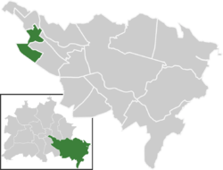 | |
| Coordinates: 52°27′54″N 13°29′10″E / 52.46500°N 13.48611°ECoordinates: 52°27′54″N 13°29′10″E / 52.46500°N 13.48611°E | |
| Country | Germany |
| State | Berlin |
| City | Berlin |
| Borough | Treptow-Köpenick |
| Founded | 1823 |
| Area | |
| • Total | 4.82 km2 (1.86 sq mi) |
| Population (2008-06-30) | |
| • Total | 16,780 |
| • Density | 3,500/km2 (9,000/sq mi) |
| Time zone | CET/CEST (UTC+1/+2) |
| Postal codes | (nr. 0903) 12437 |
| Vehicle registration | B |

Baumschulenweg is a German locality (Ortsteil) within the Berlin borough (Bezirk) of Treptow-Köpenick. Until 2001 it was part of the former borough of Treptow. Its name means road (weg) of the plant nurseries (Baumschulen). It was named after the Späth nursery.
History
The village was first settled around 1823 and in 1920, as part of the former municipality of Treptow, it merged into Berlin with the "Greater Berlin Act". In 1945 it became an autonomous locality separated from Alt-Treptow. From 1961 to 1989 Baumschulenweg was crossed by the Berlin Wall due to its position on East Berlin partially bounded by West Berlin.[1] Sonnenallee once featured a checkpoint to Neukölln.[2]
Geography
Overview
Baumschulenweg is located in south-east Berlin and is crossed by the river Spree and the canals of Britz and Teltow. It borders with Plänterwald, Oberschöneweide, Niederschöneweide, Johannisthal, Neukölln, Britz and Rudow. The boundaries with this 3 Ortsteile of Neukölln district are almost totally remarked by the two canals.
Subdivision
Baumschulenweg counts 1 zone (Ortslage):
- Späthsfelde
The area, divided by the Zweigkanal and linked by the bridge Baumschulenbrücke to the centre of Baumschulenweg, is the southern and the biggest one.
Transport
Baumschulenweg is served by the S-Bahn lines S45, S46, S47, S8, S85 and S9 at the homonymous railway station. It counts also the ferry line F11 [3] to Oberschöneweide over the Spree and is crossed, in Späthsfelde borders, by the motorway A113. The exits serving the locality are "Späthstraße" (n.2) and "Johannisthaler Chaussee" (n.3).
Personalities
- Alwin Gerisch (1857–1922), politician
- Franz Späth (1839–1913), botanist
Photogallery
-
Franz Späth's villa in the "Späth-Arboretum"
-
.jpg)
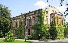
Church "Zum Vaterhaus"
-

Berlin-Baumschulenweg S-Bahn station
-

The Baumschulenbrücke in 1950
References
- ↑ (German) Historical infos about Baumschulenweg Archived July 29, 2010, at the Wayback Machine.
- ↑ The former border crossing at Sonnenallee on www.berlin.de Archived February 14, 2010, at the Wayback Machine.
- ↑ (German) F11 line on BVG website
External links
![]() Media related to Baumschulenweg at Wikimedia Commons
Media related to Baumschulenweg at Wikimedia Commons
- (German) Baumschulenweg page on www.berlin.de
| |