Waidmannslust
| Waidmannslust | |
|---|---|
| Quarter of Berlin | |
|
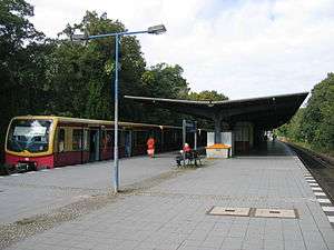
The railway station | |
 Waidmannslust | |
Location of Waidmannslust in Reinickendorf district and Berlin 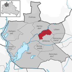 | |
| Coordinates: 52°36′24″N 13°19′15″E / 52.60667°N 13.32083°ECoordinates: 52°36′24″N 13°19′15″E / 52.60667°N 13.32083°E | |
| Country | Germany |
| State | Berlin |
| City | Berlin |
| Borough | Reinickendorf |
| Founded | 1875 |
| Area | |
| • Total | 2.3 km2 (0.9 sq mi) |
| Population (2008-06-30) | |
| • Total | 10,022 |
| • Density | 4,400/km2 (11,000/sq mi) |
| Time zone | CET/CEST (UTC+1/+2) |
| Postal codes | (nr. 1207) 13469 |
| Vehicle registration | B |
| Website | Official website |
Waidmannslust is a German locality (Ortsteil) within the borough (Bezirk) of Reinickendorf, Berlin.
History
The locality was created in 1875 as a Villenkolonie.[1] In 1920 it merged in the city of Berlin with the Greater Berlin Act. During the period 1949–1990 it was part of the French sector of West Berlin. Some building elements and some street names (e.g. Avenue Charles de Gaulle, Allee Marie Curie, Rue Montesquieu) bear testament to the former French presence in this area.
Geography
Overview
Situated in the north-western suburb of Berlin, not too far from Tegel's forest and lake, it borders the localities of Hermsdorf, Lübars, Wittenau and Tegel.
Subdivision
The locality is subdivided into 2 zones (Ortslagen):
- Schwarzwald-Siedlung (Rollberge Siedlung)
Transport
The locality is served by S-Bahn, at Berlin Waidmannslust station, on S1 and S85 lines.
It is also served by A 111 motorway, at the exit n.4, named "Waidmannsluster Damm/Hermsdorfer Damm".
Personalities
- Elga Brink (1905–1985), actress
- Marlies Wanjura (b. 1945), former mayor of Reinickendorf borough
References
Literature
- Klaus Schlickeiser: "Waidmannslust, Vom Wirtshaus zum Ortsteil Reinickendorfs" - Berlin 2000, ISBN 3-927611-15-8
- Manfred Mendes: "Leben in Waidmannslust, Geschichten, Episoden, Berichte, Bilder" - Mendes Eigenverlag, Berlin 2004
External links
![]() Media related to Waidmannslust at Wikimedia Commons
Media related to Waidmannslust at Wikimedia Commons
- (German) Waidmannslust official website
- (German) Waidmannslust page of Reinickendorfer site
| |