Bay Lake, Florida
| Bay Lake, Florida | ||
|---|---|---|
| City | ||
| ||
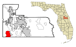 Location in Orange County and the state of Florida | ||
 U.S. Census Map | ||
| Coordinates: 28°23′29″N 81°34′0″W / 28.39139°N 81.56667°WCoordinates: 28°23′29″N 81°34′0″W / 28.39139°N 81.56667°W | ||
| Country |
| |
| State |
| |
| County | Orange | |
| Government | ||
| • Mayor | Todd Watzel | |
| • Council Member | Mark Krause | |
| • Council Member | Morgan Palfreyman | |
| • Council Member | Patrick McCall | |
| • Council Member | Joel Edwards | |
| Area | ||
| • Total | 22.8 sq mi (59.1 km2) | |
| • Land | 21.5 sq mi (55.7 km2) | |
| • Water | 1.4 sq mi (3.5 km2) | |
| Elevation | 92 ft (28 m) | |
| Population (2010) | ||
| • Total | 47 | |
| • Density | 2.1/sq mi (0.80/km2) | |
| Time zone | Eastern (EST) (UTC-5) | |
| • Summer (DST) | EDT (UTC-4) | |
| ZIP code | 32830 | |
| Area code(s) | 407 | |
| FIPS code | 12-04150[1] | |
| GNIS feature ID | 0302706[2] | |
Bay Lake is a city in Orange County, Florida, United States. The population was 47 at the 2010 census.[3] It is named after a lake located east of the Magic Kingdom. All four of the Walt Disney World theme parks, and one of the two water parks, are located in Bay Lake.
Bay Lake is one of two Florida municipalities controlled by the Walt Disney Company, the other being Lake Buena Vista. The city is part of the Orlando–Kissimmee–Sanford Metropolitan Statistical Area.
History
Chapter 67-1104 of the Laws of Florida, incorporating the city of Bay Lake, was signed into law by Governor Claude R. Kirk, Jr. on May 12, 1967, the same day he also signed chapters 67-764 (creating the Reedy Creek Improvement District, or RCID) and 67-1965 (incorporating the City of Reedy Creek). It was and still is located fully inside the RCID, and all its duties have been taken care of by the RCID. As fully described in Reedy Creek Improvement District, the city has always been controlled by the Walt Disney Company and has allowed them powers that other area attractions have not had.
Chapter 69-836, which became a law on July 3, 1969, without the governor's approval, redefined the city boundaries to exclude the easternmost part. Chapter 69-1527, which became a law the same day, completely moved the city of Reedy Creek, with the land given up by Bay Lake included in the new city. Since then, Bay Lake has expanded to fill the original RCID west of Bonnet Creek, but the Reedy Creek Improvement District has expanded to include new land not in the city.
The RCID had all the powers of the city and more, raising the question of why cities were incorporated inside of it. Walt Disney's original plans for the site included at least one futuristic living area, a planned "community of the future". This was never built, but some of the ideas were incorporated into the EPCOT theme park. The later Celebration, Florida, was deannexed from the city and the RCID in 1994 so the Walt Disney Company would not lose control of the district. The only residents of the city are Disney employees and their immediate family members who live in a community on the north shore of Bay Lake (on Bay Court). The only landowners are fully owned subsidiaries of The Walt Disney Company, rights-of-way for state and county roads, and five five-acre (20,000 m²) lots owned by senior Disney employees to give them voting power in the Reedy Creek Improvement District.
Geography
Bay Lake is located at 28°23′29″N 81°34′0″W / 28.39139°N 81.56667°W (28.391502, -81.566659).[4]
According to the United States Census Bureau, the city has a total area of 22.8 square miles (59.1 km2), of which 21.5 square miles (55.7 km2) is land and 1.4 square miles (3.5 km2) (5.86%) is water.[5]
The principal border that divides the cities of Lake Buena Vista to the east and Bay Lake to the west is the canal called Bonnet Creek, adjacent to Bonnet Creek Parkway. Most of the attractions associated with the Walt Disney World Resort are actually located within the City of Bay Lake, including all four theme parks.
Demographics
| Historical population | |||
|---|---|---|---|
| Census | Pop. | %± | |
| 1970 | 24 | — | |
| 1980 | 74 | 208.3% | |
| 2000 | 23 | — | |
| 2010 | 47 | 104.3% | |
| Est. 2015 | 50 | [6] | 6.4% |
As of the census[1] of 2000, there were 23 people, 9 households, and 6 families residing in the city. The population density was 1.2 inhabitants per square mile (0.4/km²). There were 9 housing units at an average density of 0.5 per square mile (0.2/km²). The racial makeup of the city was twenty-two whites and one black. None of the people in Bay Lake were Hispanics or Latinos.
There were nine households in Bay Lake, out of which three had children under the age of 18 living with them, five had married couples living together, one had a female householder with no husband present, and three of the households were non-families. Three households were made up of individuals and one consisted of someone living alone who was 65 years of age or older. The average household size was 2.56 and the average family size was 3.00.
The median income for a household in the city was $86,288, and the median income for a family was $86,288. Males had a median income of $76,284 versus $21,667 for females. The per capita income for the city was $26,731. None of the population and none of the families were below the poverty line.
Because of Bay Lake statistics, legislators have to be careful not to use the words "maximum" and "average" in the computations used for the State of Florida's 2007 property tax reform debate. For example, in 2006 the “per capita levy” of property tax in Bay Lake was $176,230. Since the statewide average that year was $475, legislators have had to be careful to distinguish the phrase "average savings" from the phrase "savings by the average taxpayer."
In 2010 Bay Lake had a population of 47. The racial and ethnic composition of the population was 72.3% white, 6.4% Asian, 4.3% of two or more races and 17.0% Hispanic or Latino.[8]
Points of interest
Education
Residents of Bay Lake are zoned to schools in the Orange County Public Schools:
- Windermere Elementary School
- Lakeview Middle School
- West Orange High School
References
- 1 2 "American FactFinder". United States Census Bureau. Archived from the original on 2013-09-11. Retrieved 2008-01-31.
- ↑ "US Board on Geographic Names". United States Geological Survey. 2007-10-25. Retrieved 2008-01-31.
- ↑ "Profile of General Population and Housing Characteristics: 2010 Demographic Profile Data (DP-1): Bay Lake city, Florida". U.S. Census Bureau, American Factfinder. Archived from the original on September 11, 2013. Retrieved September 20, 2012.
- ↑ "US Gazetteer files: 2010, 2000, and 1990". United States Census Bureau. 2011-02-12. Retrieved 2011-04-23.
- ↑ "Geographic Identifiers: 2010 Demographic Profile Data (G001): Bay Lake city, Florida". U.S. Census Bureau, American Factfinder. Archived from the original on September 11, 2013. Retrieved September 20, 2012.
- ↑ "Annual Estimates of the Resident Population for Incorporated Places: April 1, 2010 to July 1, 2015". Retrieved July 2, 2016.
- ↑ "Census of Population and Housing". Census.gov. Archived from the original on May 11, 2015. Retrieved June 4, 2015.
- ↑ 2010 census report for Bay Lake
External links
![]() Media related to Bay Lake, Florida at Wikimedia Commons
Media related to Bay Lake, Florida at Wikimedia Commons
- Information at Reedy Creek Improvement District website
- Terraserver image of the community where all residents live
Municipalities and communities of Orange County, Florida, United States | ||
|---|---|---|
| Cities |  | |
| Towns | ||
| CDPs |
| |
| Unincorporated communities | ||
| Footnotes | ‡This populated place also has portions in an adjacent county or counties | |