Gulf of Naples


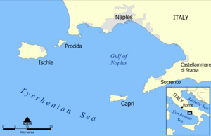
The Gulf of Naples (Italian: Golfo di Napoli; Latin: Crater), also called the Bay of Naples, is a roughly 15-kilometer-wide (9.3 mi) gulf located along the south-western coast of Italy (province of Naples, Campania region). It opens to the west into the Mediterranean Sea. It is bordered on the north by the cities of Naples and Pozzuoli, on the east by Mount Vesuvius, and on the south by the Sorrentine Peninsula and the main town of the peninsula, Sorrento. The Peninsula separates the Gulf of Naples from the Gulf of Salerno, which includes the Amalfi coast.
The islands of Capri, Ischia and Procida are located in the Gulf of Naples.[1] The area is a tourist destination, with the seaside Roman ruins of Pompeii and Herculaneum at the foot of Mount Vesuvius (destroyed in the AD 79 eruption of Vesuvius), along the north coast.
Fin Whales can sometimes be seen in Gulf of Pozzuoli.[2]
History
It is said that The Roman emperor Caligula built a bridge of boats across the bay and rode across it in a chariot wearing the armor of Alexander the Great.[3]
The Gulf of Naples hosted the sailing events for the 1960 Summer Olympics in Rome.
According to information Mario Scaramella twenty nuclear torpedo sea mines were alleged by the International Atomic Energy Agency to have been laid on 10 January 1970, by a Soviet November class attack submarine, in the Gulf of Naples in a time of war to destroy or deny access to the US Sixth Fleet; they are believed to still be on the seabed.[4]
References
- ↑ Gulf of Naples islands (PDF).
- ↑ balena nel golfo di pozzuoli - YouTube
- ↑ Scullard, H. From the Gracchi to Nero. p. 284.
- ↑ "Soviet Navy left 20 nuclear warheads in the Bay of Naples", The Independent.
External links
- 1960 Summer Olympics official report. Volume 1. p. 86.
- 1960 Summer Olympics official report. Volume 2. Part 2. pp. 963–1023.
- Purcell, N., R. Talbert, T. Elliott, S. Gillies. "Places: 433059 (Puteolanus Sinus/Crater)". Pleiades. Retrieved March 8, 2012.
| Wikimedia Commons has media related to Gulf of Naples. |
Coordinates: 40°44′07″N 14°16′31″E / 40.73528°N 14.27528°E
