Beit Netofa Valley
The Beit Netofa Valley (Hebrew: בקעת בית נטופה) is a valley in the Lower Galilee region of Israel, midway between Tiberias and Haifa. Covering 46 km2, it is the largest valley in the mountainous part of the Galilee and one of the largest in the southern Levant.[1] The name Beit Netofa Valley first appears in the Mishna and later in medieval rabbinical literature, receiving its name from the Roman-era Jewish settlement of Beth Netofa which stood at its northeastern edge. The valley's Arabic name is Sahl ˀal-Baṭūf and as such appears as Vallée Battof in crusader documents.[2]
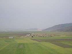
Geography and climate
.jpg)
The valley is 16 km long and on average 3 km wide, a graben formed by two parallel east-west trending faults running to its north and south.[3] It lies between two horsts forming the Yodfat range to the north and the Tur'an range to the south, basically separating the Heart of Galilee from Nazareth area. Limestone hills to the east indicate the valley was also shaped by karstic processes. Long and narrow and ringed by steep hills, the valley soil is fatty clay relatively impermeable to water,[4] leading to seasonal winter flooding, a phenomenon already described in the 14th century by medieval Arab geographer Al-Dimashqi.
On February 7, 1950, a meteorological station in the valley recorded the lowest temperature ever recorded in Israel, -13.7 °C.[5]
Settlements
Because the bottom of the valley is set under water by the winter rains, and due to the high agricultural value of the valley, villages have only been established at the margins of the valley, where the terrain starts rising. These are, from west to east, Kibbutz Hanaton, Kafr Manda, Rumana, Uzeir, Bu'eine Nujeidat and Eilabun. The Jewish religious communal settlement of Mitzpe Netofa is overlooking the valley from Mount Tur'an, which separates the Beit Netofa and Tur'an valleys.
The fertile valley land is used for agriculture and is largely owned and cultivated by the inhabitants of settlements either from the valley itself, or from nearby areas. The latter category includes inhabitants of the Arab settlements of Sakhnin, Arraba and Bi'ina, and of the Jewish settlements of Yodfat, Zippori and Kibbutz HaSolelim.
National Water Carrier
The Beit Netofa Canal, a part of Israel's National Water Carrier, runs through the valley. The 17-kilometer-long open canal was built with an oval base due to the clay soil. The width of the canal is 19.4 meters, the bottom is 12 meters wide and it is 2.60 meters deep. At the southwestern edge of the Beit Netofa Valley it reaches the two Eshkol reservoirs, where the water is cleaned and tested before flowing south towards the Negev.[4]
Archaeological sites
Several archaeological sites litter the valley. The earliest, Netofa I and II, date from the Chalcolithic period and are found on its hilly western flank near Kafr Manda. The assemblages found at the sites are rich in flint artifacts and tools and include bifacial tools, scrapers, sickle blades and retouched blades. Finds also include an arrow head and pottery. The sites are farming villages of a size and richness previously unknown in the Chalcolithic Galilee.[6]
Two tells stand on the valley floor. The first is Tel Hanaton (Tell Bedeiwiyeh), which occupies roughly 5 hectares and dominates the western end of the valley. Hanaton has been identified as the Hinnatuni of the Amarna letters, and according to the Bible, it and the surrounding regions fell under the control of the tribe of Zebulun.[1][7] The second tell, Tell el-Wayiwat, is 0.4 hectares in size and rises 3.5 meters above the valley floor at its eastern edge.[1] Two seasons of excavations were carried out at the site in 1986 and 1987 by Beth Alpert Nakhai, J.P. Dessel and Bonnie L. Wisthoff on behalf of the University of Arizona, the William F. Albright Institute of Archaeological Research and the American Schools of Oriental Research.[8] These have revealed five major strata, dating from the Middle Bronze Age through to the 11th century BCE, in the Iron Age.[1]
At the valley's northeastern edge stands the site of ancient Beth Netofa, its name preserved in the Arab place name, Khirbet Natif. It shows signs of habitation from the Iron Age through the Persian and Roman periods and up to medieval times.[2] Nearby, next to Highway 65 that runs along the eastern edge of the valley, lies Hurvat Amudim, another Roman-era Jewish settlement. Khirbet Qana, on the north edge of the valley, has long been recognized as the biblical Cana of Galilee, the site of Jesus' first miracle (John 2:11).[9]
Jewish priestly presence after 70 CE
Following the Temple's destruction at the end of the First Jewish Revolt and the displacement to the Galilee of the bulk of the remaining Jewish population in Judea at the end of the Bar Kochba Revolt, Jewish tradition in the Talmud and poems from the period record that the descendants of each priestly watch established a separate residential seat in towns and villages of the Galilee, and maintained this residential pattern for at least several centuries in anticipation of the reconstruction of the Temple and reinstitution of the cycle of priestly courses. Specifically, this Kohanic settlement region stretched from the Beit Netofa Valley, through the Nazareth region to Arbel and the vicinity of Tiberias.
See also
References
- 1 2 3 4 Meyers (1999), pp. 9-14
- 1 2 Leibner (2009), pp. 195-201
- ↑ Horowitz (2001), p. 170
- 1 2 Kantor, Shmuel. "The National Water Carrier". University of Haifa. Retrieved September 12, 2010.
- ↑ "Climate Extremes in Israel". Israel Meteorological Service. Archived from the original on 6 October 2010. Retrieved September 13, 2010.
- ↑ Gilead, I. (1989). "Chalcolithic Sites in Beit Netofa Valley, Lower Galilee, Israel". Paléorient. 15 (1): 263–267. doi:10.3406/paleo.1989.4502.
- ↑ Meyers (1999), p. 31
- ↑ "Tell el-Wawiyat, 1987". University of Arizona. Retrieved September 13, 2010.
- ↑ Robinson (1856), p. 3:108
Bibliography
- Horowitz, Aharon (2001). The Jordan Rift Valley. Taylor & Francis. ISBN 978-90-5809-351-6.
- Leibner, Uzi (2009). Settlement and history in Hellenistic, Roman, and Byzantine Galilee: an archaeological survey of the Eastern Galilee. Mohr Siebeck. ISBN 978-3-16-149871-8.
- Meyers, Eric M. (1999). Galilee Through the Centuries: Confluence of Cultures. Eisenbrauns. ISBN 978-1-57506-040-8.
- Robinson, E.; E. Smith; et al. (1856). Later Biblical Researches in Palestine. London: John Murray.
Coordinates: 32°48′34.44″N 35°19′56.86″E / 32.8095667°N 35.3324611°E