Hurvat Amudim
| חורבת עמודים, שדה עמודים | |
 Ancient synagogue. | |
 Shown within Israel | |
| Coordinates | 32°48′55″N 35°24′36″E / 32.815214°N 35.409983°E |
|---|---|
Hurvat Amudim or Sde Amudim was an ancient village, now an archaeological site, in Israel, located south-east of the Beit Netofa Valley, on the eastern side of Highway 65 between Golani Interchange and Kadarim Junction.
History
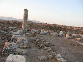
The name derives from the columns that once supported the roof of the synagogue and that remained standing.[1]
G.Dalman suggested identifying the site with Kfar Uziel, mentioned in rabbinical sources, home to one of the 24 priestly families that settled in the Galilee from the 2nd century CE onward.[2] The town was abandoned in the late 4th century.
Synagogue
A synagogue, one of the largest in the Galilee (25 x 14 meters), was built at the end of the 3rd century or the beginning of the 4th century. The building featured two rows of columns. An Aramaic inscription in the floor mosaic reads: "Remembered well... bar Tanhum, who made this pavement of mosaic and roof. May he be blessed. Amen. Selah." A second inscription reads, "Yo'ezer the hazan and Simeon his brother made this gate of the Lord of Heaven." [3]
See also
References
| Wikimedia Commons has media related to Sdeh Amudim. |
- ↑ Levine, Lee I. (1981). Excavations at Horvat ha-Amudim. Ancient Synagogues Revealed. The Israel Exploration Society. pp. 78–81.
- ↑ Dalman, Gustaf (1935). Sacred Sites and Ways. London. pp. 52, 115–116.
- ↑ Aviam, Mordechai (1997). Ancient Synagogues in the Land of Israel. Israel Nature and Parks Authority. p. 17.