Benham Plateau
| Benham Plateau Benham Rise | |
|---|---|
.svg.png) Benham Plateau Location in the Philippines | |
| Coordinates: 16°30′N 124°45′E / 16.500°N 124.750°ECoordinates: 16°30′N 124°45′E / 16.500°N 124.750°E | |
| Country |
|
The Benham Plateau, also known as the Benham Rise, is a seismically active undersea region and extinct volcanic ridge located in the Philippine Sea approximately 250 km (160 mi) east of the northern coastline of Dinapigue, Isabela.
Under the Philippine Sea lie a number of basins including the West Philippine Sea Basin, inside of which is located the Central Basin Fault (CBF).[1] The Benham Plateau is located in the CBF and its basement probably is a micro-continent.[2] Several scientific surveys have been made on the feature to study its nature and its impact on tectonic subduction, including one about its effects on the 1990 Luzon earthquake. The area is a territory of the Philippines which was claimed, as part of its continental shelf, which was then lodged with the United Nations Commission on the Limits of the Continental Shelf on April 8, 2009 and was approved by the United Nations Convention on the Law of the Sea (UNCLOS) in 2012.[3]
Geological features
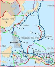
Benham Rise is a submerged extinct volcanic ridge located at 16 degrees 30 minutes N, 124 degrees 45 minutes E off the coast of Luzon, with the size of about 250 km in diameter and rises over 2,000 meters (2 km.) above the sea floor, from below 5,000 meters (5 km.) below sea level to above 3,000 meters (3 km.) below sea level. Its area is close to the Benham Seamount, located at 15 degrees 48 minutes N, 124 degrees 15 minutes E. The precise location is somewhere near the east of the Philippine Trench and near the south of the East Luzon Trench, both of which absorb the subducting force of the Philippine Sea Plate under the Philippine Mobile Belt,[4] a collage of large blocks of that crust that amalgamated prior to the collision of the Philippine Sea Plate with the Eurasian Plate.[5]
The origin of the landform, along with a fellow landform, the Urdaneta Plateau (a remnant of mantle plume), is identified in one study as at least five sequences of propagating rifts, probably triggered by mantle flowing away from the mantle thermal anomaly.[6] Its presence of the landform disrupts the continuity of this region (known as the Philippine-East Luzon Trench) by continuously colliding with the Sierra Madre mountain range of eastern portion of the island of Luzon. Though it is generally thought that the Philippine Sea Plate is being subducted under the Philippine Mobile Belt, under the rules of tectonic subduction, there appears to be a resistance to this because of the presence of the landform, and instead, the plate is being displaced into the northern portion of Luzon to the west.[7][8]
The geophysical features of the plateau may have been the result of an early Miocene collision event between the Benham Rise and the eastern margin of Luzon, which may have also allowed the inception of the NW striking strand of the Philippine fault.[9] These forces may have impacted the shape of the island of Luzon because of the basaltic sea floor resisting the subduction that may have also cause the bending of the Philippine Fault.[10] The active basins in Central Luzon, which trace an asymmetrical V shape, is the best place to observe recent tectonic evolution of the fault system.
History
The landform is presumably named after Admiral Andrew Ellicot Kennedy Benham (1832–1905) by American surveyors who were the probable discoverers of the geological feature. He was a United States Navy officer, who served with both the South Atlantic and West Gulf Blockading Squadrons during the American Civil War.[11] There has been speculation in the scientific community about the nature of the landform. Following the major 16 July 1990 Luzon earthquake, scientists reconsidered their fault models and decided it likely that Benham Plateau has similarly displaced the Philippine Fault System to the west.[12] After analysing older models such as that of Pinet and Stephan (1989), scientists reconsidered their fault models. They thought that it is highly likely that the Benham Plateau is still displacing Central Luzon and the Philippine Fault System to the west, which may have had an impact in causing such a catastrophic earthquake. The 20 second to 50 second wave in the 1990 quake that developed a new east-west sub-fault was so strong that it terminated disastrously at the city of Baguio in Benguet, Cordillera. Several scientific surveys, conducted between 2004 and 2008, collected hydrographic data that determined the morphology of the seabed in the region. Additional data from international bathymetric surveys and an analysis of international research projects were collected to support the findings.[13]
Benham Rise has been part of the culture of ancient Filipinos. Ancient Catanduanes people have fished and roamed the area long before the colonial era. In fact, it is celebrated in Catandunganons' folktales, legends and poetry. Today, large percentage of fish caught by Catandunganon comes from Benham Rise. Its local bicol term is called Kalipung-awan (means loneliness in an isolated place).
Philippine claim
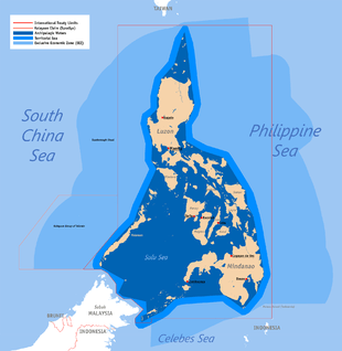
Despite its proximity to the archipelago, the plateau was previously not included in the territory of the Philippines. On 8 April 2009, the Republic of the Philippines lodged a partial territorial waters claim with the United Nations Commission on the Limits of the Continental Shelf in relation to the continental shelf in the region of Benham Rise.[14] It was submitted as part of petition expanding the archipelago's baselines and exclusive economic zone through a law that also included other claims involving disputed territories of the Kalayaan Islands (Spratly Islands) and Scarborough Shoal. Although the landform, in itself, is not disputed, the petition still received some criticism inside and outside the country because of its controversial nature.[15] According to the government's claim, based on a set of guidelines by the Commission on the Limits of the Continental Shelf, the area satisfies the 350-mile constraint line since the outer limits of the continental shelf are located landward of the constraint line, which is located 350 miles from the baselines where the measurement of the breadth of the territorial sea begins.[13]
The Congress of the Philippines enacted Republic Act No. 9522, also known as the Archipelagic Baselines Law, which is the basis of the claim. According to the document the region is bounded by the Philippine Basin on the north and east, and by Luzon on the west and south. It asserted that, according to scientific data based on seismic, magnetic, other geological features, the Benham Rise is an extension of the Philippines’ continental shelf. In summary, the baselines, the basis used for delineating the maritime territorial and jurisdictional zones (including the continental shelf), conform with the requirements of the UN Convention of the Law of the Sea (UNCLOS).[13] The claim is only a partial claim since the law that allows the Philippines to expand its territorial boundaries also includes islands in the South China Sea.
UN Decision
The Philippines filed its claim for Benham Rise in 2008 in compliance with the requirements of the United Nations Convention on the Law of the Sea (UNCLOS). The UN has officially approved the claim in April 2012.[3][16][17][18]
References
- ↑ Hickey-Vargas, R.; Sato, H.; Machida, S.; Ishii, T.; Hirano, N.; Yumul, G.; Fujioka, K. "Isotopic Characteristics of Basalts From the Central Basin Fault, West Philippine Basin". Harvard University. Retrieved September 26, 2009.
Fall Meeting 2001
- ↑ Avijit Gupta. The physical geography of Southeast Asia (2005 ed.). Oxford University Press. p. 14. ISBN 0-19-924802-8. - Total pages: 440
- 1 2 "UN approves PH territorial claim to Benham Rise". Retrieved April 28, 2012.
- ↑ Hashimoto, M, ed., (1981) Accretion Tectonics in the Circum-Pacific Regions, ISBN 90-277-1561-0 p299
- ↑ Rangin and Pubellier (1990) in Tectonics of Circum-Pacific Continental Margins ISBN 90-6764-132-4 p149
- ↑ Ryuichie, Shinjo; Ni Xianglonga; Wu Shiguoc (June 2008). "Tectonics in the Northwestern West Philippine Basin". Journal of China University of Geosciences. 19 (3): 191–199. doi:10.1016/S1002-0705(08)60038-2. Retrieved September 27, 2009.
- ↑ Rangin and Pubellier (1990) in Tectonics of Circum-Pacific Continental Margins ISBN 90-6764-132-4, p149
- ↑ Deschamps and Lallemand (2003) in Intra-Oceanic Subduction Systems: Tectonic and Magmatic Processes ISBN 1-86239-147-5 p165
- ↑ Ringenbach, J. C.; N. Pinet; J. F. Stephan; J. Delteil (1993). "STRUCTURAL VARIETY AND TECTONIC EVOLUTION OF STRIKE-SLIP BASINS RELATED TO THE PHILIPPINE FAULT SYSTEM, NORTHERN LUZON, PHILIPPINES". Tectonics. 12 (1): 187–203. doi:10.1029/92TC01968. Retrieved September 27, 2009.
- ↑ Rantucci, Giovanni (Oct 1994). "Geological disasters in the Philippines : The July 1990 earthquake and the June 1991 eruption of Mount Pinatubo". United Nations. ISDR. Retrieved September 27, 2009., Document ID:13258
- ↑ "Benham One-Name Study". Guild of One-Name Studies. 8 Mar 2008. Retrieved September 27, 2009.
- ↑ Pinet and Stephan (1989) in Tectonics of Circum-Pacific Continental Margins ISBN 90-6764-132-4 p.179
- 1 2 3 Tessa Jamandre (12 April 2009). "RP files claim over Benham Rise with UN". verafiles.org. Archived from the original on April 26, 2009. Retrieved September 27, 2009.
- ↑ "Submissions, through the Secretary-General of the United Nations, to the Commission on the Limits of the Continental Shelf, pursuant to article 76, paragraph 8, of the United Nations Convention on the Law of the Sea of 10 December 1982". United Nations Commission on the Limits of the Continental Shelf. 28 May 2009. Retrieved 29 May 2009.
- ↑ Ellen Tordesillas (March 25, 2008). "RP in last minute scramble to beat UN deadline". ellentordesillas.com. Retrieved September 27, 2009.
- ↑ UN to decide on Phl claim on 13-M hectare Benham Rise, August 16, 2011, Philippine Star.
- ↑ UN approves PH territorial claim to Benham Rise, April 28, 2012, Philippine Daily Inquirer.
- ↑ DOE to assess resource potential of Benham Rise:http://www.philstar.com/headlines/2014/06/09/1332626/doe-assess-resource-potential-benham-rise
External links
Geography of the Philippines | ||
|---|---|---|
| Geology |  | |
| Landforms |
| |
| Water | ||
| Seas | ||
| Environment |
| |