List of active volcanoes in the Philippines
Active volcanoes in the Philippines, as categorized by the Philippine Institute of Volcanology and Seismology (PHIVOLCS), include volcanoes in the country having erupted within historical times (within the last 600 years), with accounts of these eruptions documented by humans; or having erupted within the last 10,000 years (holocene) based on analyses of datable materials. However, there is no consensus among volcanologists on how to define an "active" volcano. As of 2012, PHIVOLCS lists 23 volcanoes as active in the Philippines, 21 of which have historical eruptions; one, Cabalian, which is strongly fumarolic volcano; and one, Leonard Kniaseff, which was active 1,800 years ago (C14).[1]
There are 50 Philippines volcanoes listed by the royal Smithsonian Institution's Global Volcanism Program (GVP) at present,[2] of which 20 are categorized as "historical" and 59 as "holocene".[2] The GVP lists volcanoes with historical, Holocene eruptions, or possibly older if strong signs of volcanism are still evident through thermal features like fumaroles, hot springs, mud pots, etc.[3]


List
The list below showing 25 active volcanoes in the Philippines was based on the PHIVOLCS list with some included from the GVP. The number is not definite and depends on someone's definition of "active" or historical timeframe. Descriptions under Eruption were based on the GVP website. The frequency of Historical Eruptions excludes questionable or Uncertain accounts based on the two sources mentioned.
| Name | Elevation (ASL)[1] | Coordinates | Province(s)[1] | Eruptions[1] | ||
|---|---|---|---|---|---|---|
| m | ft | Description and current status | ||||
| Ambalatungan Group | 2,329 | 7,641 | 17°18′40″N 121°06′13″E / 17.310982°N 121.103668°E | Kalinga | 0 | Explosions in 1952 is uncertain.[4] Fumarolic with solfataras and thermal springs. |
| Babuyan Claro | 843 | 2,766 | 9°31′23″N 121°56′24″E / 9.523°N 121.940°E | Cagayan | 3 | Eruptions were recorded in 1831, 1860 and 1913. Askedna Hot Springs is located in the southern base of the volcano. |
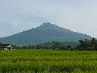
| Banahaw | 2,169 | 7,116 | 14°04′N 121°29′E / 14.07°N 121.48°E | Quezon | 0 | Eruptions were uncertain during the mudflows of 1730, 1743, 1843 and 1909.[5] |
| Biliran | 1,340 | 4,400 | 11°33′29″N 124°30′47″E / 11.558°N 124.513°E | Biliran | 1 | Phreatic eruption in 1939. Fumarolic with thermal springs |
| Bulusan | 1,565 | 5,135 | 12°46′12″N 124°03′00″E / 12.770°N 124.05°E | Sorsogon | 17 | Eruptions years are from 1886 to 2011. Permanently monitored |
| Cabalian[1] | 10°17′13.2″N 125°13.25′0″E / 10.287000°N 125.22083°E | Southern Leyte | ||||
| Cagua | 1,160 | 3,810 | 18°13′19″N 122°07′23″E / 18.222°N 122.123°E | Cagayan | 1 | Eruption in 1860 and strong solfataric activity in 1907. Thermal areas are located near the summit and NW to NNE flanks. |
| Camiguin de Babuyanes | 712 | 2,336 | 18°49′48″N 121°51′36″E / 18.83°N 121.860°E | Cagayan | 1 | Its only recorded eruption was in 1857. Fumarolic with thermal springs |
| Didicas | 843 | 2,766 | 19°04′37″N 122°12′07″E / 19.077°N 122.202°E | Cagayan | 6 | Eruptions in 1773, 1856, 1900, 1952, 1969 and 1978. A submarine volcano till 1952 when a permanent island was formed.[6] |
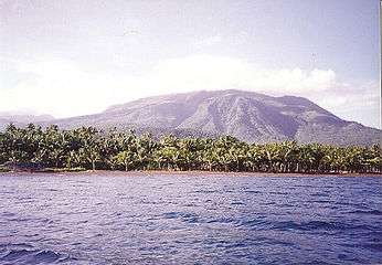
| Hibok‑Hibok | 1,332 | 4,370 | 9°12′11″N 124°40′23″E / 9.203°N 124.673°E | Camiguin | 5 | Eruption in years 1827, 1862, 1871 and 1948–1952. Activity from 1897-1902 was only solfataric. Permanently monitored. |
| Iraya | 1,009 | 3,310 | 20°28′08″N 122°00′36″E / 20.469°N 122.010°E | Batanes | 1 | Last eruption was in 1454. Seismic swarm in 1998. |
| Iriga | 1,143 | 3,750 | 13°27′25″N 123°27′25″E / 13.457°N 123.457°E | Camarines Sur | 0 | The eruption in 1628 was discredited.[7] |
| Jolo Group | 620 | 2,030 | 6°00′47″N 121°03′25″E / 6.013°N 121.057°E | Sulu | 0 | Uncertain submarine eruption in 1897. Listed as Bud Dajo, a cinder cone on Jolo Island, in the PHIVOLCS list. |
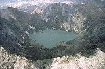
| Kanlaon | 2,435 | 7,989 | 10°24′43″N 123°07′55″E / 10.412°N 123.132°E | Negros Occidental, Negros Oriental | 26 | Eruptions were recorded from 1886 to 2006. On November 23, 2015 the volcano had a small, steam-driven explosion. PHIVOLCS raised the alert level to 1 (mild restiveness). Permanently monitored. |
| Leonard Kniaseff | 200 | 660 | 7°22′55″N 126°02′49″E / 7.382°N 126.047°E | Compostela Valley | 0 | Last eruption was dated as c.120 AD.[8] Strong thermal features. |
| Makaturing | 1,940 | 6,360 | 7°38′49″N 124°19′12″E / 7.647°N 124.32°E | Lanao del Sur | 2 | Eruption recorded in 1865 and 1882. The 1856 and 1858 eruptions was credited to Ragang[9][10] |
| Matutum | 2,286 | 7,500 | 6°22′N 125°04′E / 6.37°N 125.07°E | South Cotabato | 0 | Mountain was fumarolic on March 7, 1911, but if an eruption occurred was uncertain. Thermal springs in Akmoan and Linan.[11][12] |
| Mayon | 2,460 | 8,070 | 13°15′25″N 123°41′06″E / 13.257°N 123.685°E | Albay | 50 | Eruptions were recorded from 1616 to 2013. Permanently monitored. Volcanic activity is identified up to present. Alert Level 3 was raised. It could be advanced to Alert Level 5. |
| Musuan | 646 | 2,119 | 7°52′37″N 125°04′05″E / 7.877°N 125.068°E | Bukidnon | 2 | Eruptions in 1866 & 1867. Strong seismic swarm in 1976. |
| Parker | 1,784 | 5,853 | 6°06′47″N 124°53′31″E / 6.113°N 124.892°E | South Cotabato | 1 | A caldera-forming eruption occurred on January 4, 1641. |
| Pinatubo | 1,445 | 4,741 | 15°08′N 120°21′E / 15.13°N 120.35°E | Zambales, Tarlac, Pampanga | 3 | Reawakened in 1991 producing the 2nd largest eruption in the 20th century. Followed by milder eruptions in 1992 and 1993. |
| Ragang | 2,815 | 9,236 | 7°42′N 124°30′E / 7.70°N 124.50°E | Lanao del Sur, Cotabato | 7 | Eruption years are from 1765 to 1873. Eruptions were uncertain in 1915 and 1916. |
| San Pablo Volcanic Field | 1,090 | 3,580 | 14°07′N 121°18′E / 14.12°N 121.30°E | Laguna, Batangas | 0 | Last activity was the formation of Sampaloc Lake around 1350 AD +/- 100 years determined by anthropology[3][13] |
| Smith | 688 | 2,257 | 19°32′02″N 121°55′01″E / 19.534°N 121.917°E | Cagayan | 6 | Eruption years are from 1652 to 1924. Combined with Babuyan Claro on the GVP list. |
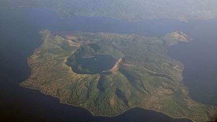
| Taal | 311 | 1,020 | 14°00′07″N 120°59′35″E / 14.002°N 120.993°E | Batangas | 33 | Eruption years is from 1572 to 1977. Showing signs of unrest since 1991 and permanently monitored. |
| Unnamed volcano (Ibugos) |
−24 | −79 | 20°20′N 121°45′E / 20.33°N 121.75°E | Batanes | 3 | Submarine eruptions in 1773, 1850 and 1854. |
See also
References
- 1 2 3 4 5 "List of Active Volcanoes". Philippine Institute of Volcanology and Seismology (PHIVOLCS). 30 July 2008. Archived from the original on 4 March 2016.
- 1 2 "Volcanoes of the Philippines and Southeast Asia". Global Volcanism Program. Smithsonian Institution. Retrieved 2011-08-18.
- 1 2 "Volcano Data Criteria". accessdate=2011-08-18. Smithsonian Institution.
- ↑ "Eruption History, Ambalatungan Group". Global Volcanism Program. Retrieved on 2011-08-18.
- ↑ "Banahaw Eruption History". Global Volcanism Program. Retrieved on 2011-08-18.
- ↑ "Didicas Eruption History". Global Volcanism Program. Retrieved on 2011-08-18.
- ↑ "Iriga Eruption History". Global Volcanism Program. Retrieved on 2011-08-18.
- ↑ "Leonard Range Eruption History". Global Volcanism Program. Retrieved on 2011-08-18.
- ↑ "Makaturing Eruption History". Global Volcanism Program. Retrieved on 2011-08-18.
- ↑ "Makaturing". Global Volcanism Program. Retrieved on 2011-08-18.
- ↑ "Matutum". Global Volcanism Program. Retrieved on 2011-08-18.
- ↑ "Matutum Eruption History". Global Volcanism Program. Retrieved on 2011-08-18.
- ↑ "San Pablo Volcanic Field Eruption History". Global Volcanism Program. Retrieved on 2011-08-18.
External links
| Wikimedia Commons has media related to Volcanoes of the Philippines. |
Geography of the Philippines | ||
|---|---|---|
| Geology |  | |
| Landforms |
| |
| Water | ||
| Seas | ||
| Environment |
| |