Bhurban
| Bhurban | |
|---|---|
| Town | |
 | |
| Country |
|
| Province | Punjab (Pakistan) |
| District | Rawalpindi |
| Time zone | PST (UTC+5) |
Bhurban (Urdu: بھوربن ) is a small town and a hill station in Punjab province, Pakistan. The resort town is named after a nearby forest. It is located approximately 9 kilometres from Murree city. [1]
Government

The Rawat Union Council is also responsible for managing Bhurban. Rawat village is the headquarters of the Union Council of Rawat, which is an administrative sub-division of Murree Tehsil, in the Rawalpindi District of Punjab.
Location
Bhurban is situated in between Murree and Kashmir Road at a height of about 6000 feet. It has recently been made accessible by the dual Islamabad-Murree Expressway, making it a 45-minute drive from Islamabad, the federal capital of Pakistan.
Tourism
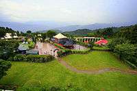
Bhurban is one of the more picturesque places in the country, and is a tourist paradise with unique flora, and a fauna with a variety species not found elsewhere in Pakistan. It is known for scenic hiking trails in the nearby Ayubia National Park. The '5 star' Pearl Continental Hotel - Mount Pleasant Apartments is one of several resorts in Bhurban that serve tourists visiting the Murree Hills and the national park. Bhurban also has a nine-hole golf course. Another beautiful resort in Bhurban is the Bhurban Hill Apartments, located 2 km from PC Bhurban. It has its own source of natural mineral water.
.jpg)
Residents
Bhurban's main resident families or tribes are Sheraals, Saidwals, mumdals tapyal Janyals, and Jogyals. Sherals are one of the biggest families in Rawat which are the children of Dada Sher Khan. Sher Ahmed Khan, Mumdal Kaya, Noor Elahi Abbasi are from the same tribe. Raheem Dad Khan is one of the elders of this tribe since 1970. His sons, Rasheed Ahmed, Zahoor Ahmed, Ashraf Khan, are the three figures of the region.
References

Coordinates: 33°57′21″N 73°27′06″E / 33.9557°N 73.4518°E