Mandrah
| Mandrah | |
|---|---|
| Union council | |
 | |
| Country |
|
| Province | Punjab |
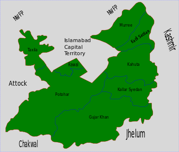
| District | Rawalpindi |
| Tehsil | Gujar Khan |
| Post Code | 47670 |
| Government | |
| • Chairman | Raja Zulfiqar Ali |
| Population (2016 (estimated)) | |
| • Total | 18,574 |
MANDRAH (Urdu: مندره) is a town of Tehsil Gujar Khan, District Rawalpindi, Punjab, Pakistan. Mandrah itself is also the chief town of Union Council Mandrah which is an administrative subdivision of the Tehsil. It is situated approximately 35 kilometers south of Rawalpindi. [1] It is located at 33°21'059.89"North, 73° 14' 22.69" East.[2]
History
Mandra was founded by descendants of General Zarab Khan. There were three brothers looking for a fertile land to settle traveling from mountains of Kahuta and then they settled there which was the beginning of the reign of Jasgam (Jaskham) Rajputs in the area of Tehsil Gujarkhan. As per tribe's history and norms, Jasgams use the title of Raja. They helped other homeless people to settle and give them shelter. Today among Mandrah's most prominent people are the Jasgam Rajputs as they own most of the land and markets in the Main Bazaar and are very active in politics.
Railways
Mandrah Railway Station is on the main Peshawar to Karachi railway line. It is situated 40 kilometers from Rawalpindi. Mandrah is also the railway junction from where the train goes to Chakwal. Though currently the Mandrah-Chakwal Line is non-operational.
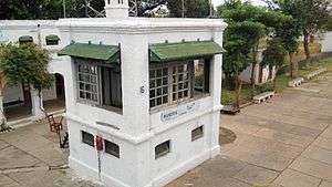
Post Office
There is a Post Office in Mandrah providing postal services to the locality.
Notable Residents
Judiciary
- Muhammad Afzal Zullah - Ex Chief Justice of Pakistan
Military (On Basis of Rank Seniority)
- Lt Gen (Retd) Tariq Pervez - Corps Commander XII Corps, Quetta [3]
- Brigadier (Retd) Muhammad Yousaf (Late) - Sitara-i-Imtiaz (Military) - Civil Engineer, War Vetern (1965 & 1971)[4]
- Brigadier (Retd) Raja Imtiaz Ayub
- Major (Retd) Raja Nadir Pervez - Sitara-e-Jurat, War Hero (1965 & 1971)
Politics
- Raja Nadir Pervez - Ex MNA & Federal Minister
- Raja Zulfiqar - Nazim Of Mandrah
References
- ↑ Towns & Unions in the City District of Rawalpindi - Government of Pakistan
- ↑ Team, Maplandia.com. "Mandra Map | Pakistan Google Satellite Maps". www.maplandia.com. Retrieved 2016-06-13.
- ↑ http://www.globalsecurity.org/military/world/pakistan/xii-corps.htm
- ↑ "Decorations and Medals of Pakistan". www.medals.pl. Retrieved 2016-06-13.

Coordinates: 33°21′059.89″N 73°14′22.69″E / 33.3666361°N 73.2396361°E