Bismarck Archipelago
|
Map of the Bismarck Archipelago | |
| Geography | |
|---|---|
| Location | Papua New Guinea |
| Coordinates | 5°00′S 150°00′E / 5.000°S 150.000°E |
| Major islands | New Britain, New Ireland |
| Area | 49,700 km2 (19,200 sq mi) |
| Administration | |
|
Papua New Guinea | |
| Region | Islands Region |
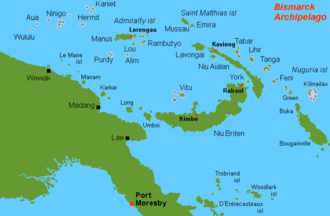
The Bismarck Archipelago is a group of islands off the northeastern coast of New Guinea in the western Pacific Ocean and is part of the Islands Region of Papua New Guinea. Its area is about 50,000 square km.
History
The first inhabitants of the archipelago arrived around 33,000 years ago from New Guinea, either by boats across the Bismarck Sea or via a temporary land bridge, created by an uplift in the Earth's crust. Later arrivals included the Lapita people.
The first European to visit these islands was Dutch explorer Willem Schouten in 1616.[1][2] The islands remained unsettled by western Europeans until they were annexed as part of the German protectorate of German New Guinea in 1884. The area was named in honour of the Chancellor Otto von Bismarck.
On 13 March 1888, a volcano erupted on Ritter Island causing a megatsunami. Almost the entire volcano fell into the ocean, leaving a small crater lake.[3]

Following the outbreak of World War I, the Australian Naval and Military Expeditionary Force seized the islands in 1914 and Australia later received a League of Nations mandate for the islands. They remained under Australian administration—interrupted only by Japanese occupation during World War II—until Papua New Guinea became independent in September 1975.
Geography
The Bismarck Archipelago includes mostly volcanic islands with a total land area of 49,700 km2 (19,189 sq mi). The archipelago encompasses the Bismarck Sea and sits upon the North Bismarck Plate, the Manus Plate and the South Bismarck Plate.
Islands are grouped here according to administrative province:
_2012.png)
- Manus Province (see 9 on the map)
- Admiralty Islands, group of 18 islands including:
- Manus Island, main island
- Los Negros Island
- Lou Island
- Ndrova Island
- Tong Island
- Baluan Island
- Pak Island
- Purdy Islands
- Rambutyo Island
- St Andrews Islands
- Western Islands, with:
- Admiralty Islands, group of 18 islands including:
- New Ireland Province (12)
- New Ireland or Niu Ailan, main island
- New Hanover or Lavongai
- Saint Matthias Group
- Tabar Group
- Lihir Group
- Tanga Group
- Feni Islands
- Dyaul Island

- East New Britain Province (4)
- New Britain or Niu Briten, main island
- Duke of York Islands
- Kabakon
- Ulu
- West New Britain Province (18)
- New Britain or Niu Briten, main island
- Vitu Islands
- Morobe Province (11)
- Umboi Island
- Tolokiwa Island
- Sakar Island
- Ritter Island
- Malai Island
- Tuam Island
- Madang Province (8)
- Long Island
- Crown Island
- Karkar Island
- Bagabag Island
- Manam
- East Sepik Province (5)
The passage of water between the islands of New Britain and New Ireland is called St. George's Channel after St. George's Channel in the British Isles between Wales and Ireland.
Notes
- ↑ Sigmond, J. P. and Zuiderbann, L. H. (1976) Dutch Discoveries of Australia, Rigby, Australia. ISBN 0-7270-0800-5
- ↑ Spate, O. H. K. (1979) The Spanish Lake, Australian National University, Second Edition, 2004. ISBN 1-920942-17-3
- ↑ Ward, Steven N.; Day, Simon (September 2003). "Ritter Island Volcano —Lateral Collapse and the Tsunami of 1888". Geophysical Journal International. Blackwell Publishing. 154 (3): 891. Bibcode:2003GeoJI.154..891W. doi:10.1046/j.1365-246X.2003.02016.x.
In the early morning of 1888 March 13, roughly 5 km3 of Ritter Island Volcano fell violently into the sea northeast of New Guinea. This event, the largest lateral collapse of an island volcano to be recorded in historical time, flung devastating tsunami tens of metres high on to adjacent shores. Several hundred kilometres away, observers on New Guinea chronicled 3-min period waves up to 8 m high, that lasted for as long as 3 h. These accounts represent the best available first-hand information on tsunami generated by a major volcano lateral collapse. In this article, we simulate the Ritter Island landslide as constrained by a 1985 sonar survey of its debris field and compare predicted tsunami with historical observations. The best agreement occurs for landslides travelling at 40 m/s, but velocities up to 80 m/s cannot be excluded. The Ritter Island debris dropped little more than 800 m vertically and moved slowly compared with landslides that descend into deeper water. Basal friction block models predict that slides with shorter falls should attain lower peak velocities and that 40+ m/s is perfectly compatible with the geometry and runout extent of the Ritter Island landslide. The consensus between theory and observation for the Ritter Island waves increases our confidence in the existence of mega-tsunami produced by oceanic volcano collapses two to three orders of magnitude larger in scale.
Bibliography
- Firth, Stewart (1983). New Guinea Under the Germans. Carlton, Australia: Melbourne University Press. ISBN 0-522-84220-8.
- Howe, K. R., Robert C. Kiste, Brij V. Lal, eds. (1994). Tides of History: The Pacific Islands in the Twentieth Century. Honolulu: University of Hawaii Press. ISBN 0-8248-1597-1.
- King, David et al. (1982). Papua New Guinea Atlas: A Nation in Transition. Bathurst, Australia: R. Brown and the University of Papua New Guinea. ISBN 0-909197-14-8.
- Moore, Clive (2003). New Guinea: Crossing Boundaries and History. Honolulu: University of Hawaii Press. ISBN 0-8248-2485-7.
- Ryan, Peter, ed. (1972). Encyclopedia of Papua New Guinea. 3 volumes; Vol I: A - K, maps, black and white illustrations, xv + 588pp. Vol II: l - Z, maps, black and white illustrations, 589-1231pp. Vol III: Index, folding colour map in rear pocket, map, colour illustration, v + 83pp. Carlton, Australia: Melbourne University Press. ISBN 978-0-522-84025-4.
External links
| Wikimedia Commons has media related to Bismarck Archipelago. |
-
 "Bismarck Archipelago". Encyclopædia Britannica (11th ed.). 1911.
 - "Bismarck Archipelago". The New Student's Reference Work. 1914.