Black Sea-Caspian Steppe
stan
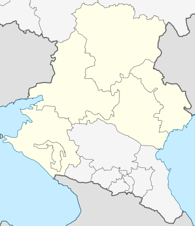
*Smaller areas along the north Caucasus are: Karachay-Cherkessia, Kabardino-Balkaria, Ossetia, Ingushetia and Chechnya
*Yellow is the Southern Federal District and Pink is the North Caucasus Federal District
River
The Black Sea-Caspian Steppe is an informal name for that part of the Eurasian Steppe that extends south between the Black and Caspian Seas. It is usually treated as part of the Pontic-Caspian steppe which includes the area north of the Black and Caspian Seas, but there is some reason to treat it as a distinct place. Its natural boundaries are the Sea of Azov and Black Sea on the west, the Caucasus Mountains on the south and the Caspian Sea on the east. Its northern boundary may be taken as the triangle formed by the lower Don River and Volga River which are about 60 km apart to the west of Volgograd. This article excludes the north slope of the Caucasus which is not steppe and has a distinct geography and history.
Geography
Administratively it comprises (clockwise) the Astrakhan Oblast along the Volga, Kalmykia (west of Astrakhan oblast and reaching the Caspian in the south of the Volga), Northern Dagestan, the Stavropol Krai in the center-south, Krasnodar Krai in the west with its inclave of Adygea, southern Rostov Oblast in the northwest and the southern Volgograd Oblast in the north-center. The largest towns are Rostov-on-Don, Volgograd and Astrakhan in the north and Krasnodar and Stavropol in the south. Main roads are Rostov southeast to Stavropol and beyond, Volgograd south to Stavropol, and Astrakhan south to Dagestan. There are railroads approximately parallel to both coasts.
The region is about 900 km at its widest and about 500 km from north to south. Low rainfall makes the whole area grassland. Rainfall decreases to the east and north (20-30 inches in the west, 13 in Volgograd and 9 in Astrakhan). Most of the area is less than 500 feet in altitude, rising to over 1000 feet in the Stavropol Highland. The Manych Depression is not much more than 65 feet above sea level and the area around Astrakhan and part of Kalmykia is below sea level.
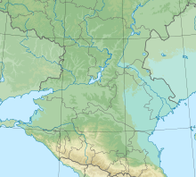
Note Tsimylansk Reservoir on the lower Don (center), Volga-Don watershed, Stavropol Highland and eastern area below sea level
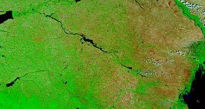
Upper left is the eastern tip of the Sea of Azov and lower right is the Caspian Sea
Rivers: Through the center runs the northwest-tending Kuma-Manych Depression. This was once a strait connecting the Black and Caspian Seas and is now marked by the Manych River which is basically a chain of lakes. It will probably be the route of the Eurasia Canal if that great engineering work is ever built. In the south the rivers that flow north from the Caucasus are caught by the west-flowing Kuban River and the east-flowing Terek River. Between these the rivers are caught by the Malka River which is an east-flowing tributary of the Terek. In the west, since the Caucasus Mountains run parallel and close to the Black Sea coast, no significant rivers from this area reach the Black Sea. The western point is the Taman Peninsula. North of the Taman Peninsula the Kuban River, the Beysug River and the Yeya Rivers reach the Sea of Azov, and the long Manych River and the shorter Sal River reach the lower Don. In the north much of the lower Don is under the Tsimlyansk Reservoir and the Volga has a broad flood plain and a large delta. North of the Manych Depression the low Ergeni Highland forms the watershed between the Don and Volga. It drops off quickly to the Caspian Depression. To the east of this the Sarpinsky Lakes are a chain of lakes in Kalmykia that would be a north-flowing river if there were more rainfall. On the east the only important rivers that reach the Caspian are the Volga, Kuma River and the Terek. In the center the Yegorlyk River and Kalaus River flow north to the Manych and the Kuma River flows northeast to the Caspian. In the east there are many shallow lakes. Since the land is flat and the rainfall barely sufficient for agriculture there are important irrigation canals, most leading from the Caucasus peidmont to the Manych Depression. The Great Stavropol Canal leads northeast from the Kuban to the Kalaus and beyond and the Nevinnomyssk Canal runs from the Kuban to the Egorlyk. The Kuma-Manych Canal feeds water from the Kuma to the East Manych and Chyornozemsky Canal irrigates the interior of Kalmykia. There numerous canals around the lower Terek.
History
From about 700 BC the dominant peoples on the western steppe were the Scythians, Sarmatians and then Alans. Turkic-speakers arrived about 600 AD and gradually replaced the original Iranian languages. The Mongols took over about 1240 and their western lands became the Golden Horde which about 1500 broke up and became the Nogai Horde. In the nineteenth century the Nogai nomads were pushed southeast and the area populated by Russian agriculturists.
Horse-based Pastoral nomadism appeared in this area some time between 4000 and 1000 BC. There is not enough data to be more specific. It is thought that the Northwest Caucasian languages are related to the ancient Hattite language and the Northeast Caucasian languages are related to Hurrian and Urartian. This implies that the mountaineers of the Caucasus have been in their present location for a very long time. According to the most common theory the Indo-European languages originated on the steppes north of the Caucasus and Black Sea. Some time before 3000 BC the Maikop culture appeared in Circassia and Kabardia. It is noted for its excellent gold and silver work. North on the steppe was the Yamnaya culture which was probably Indo-European. Around 1000 BC there was a bronze-age Koban culture in the Kabardian area which may have been proto-Chechen. Iron appeared in the eighth century BC.
The small western area around the Taman peninsula had a distinct history since it was in contact with the literate civilizations of the Mediterranean basin. From the eighth century Greeks founded colonies around the Black Sea and we begin to have written reports. Maeotians was the Greek name for the peoples around the Sea of Azov. The Hellenized Sindi people appeared with a possible capital or seaport at Anapa. Both were perhaps ancestors of the Circassians. The Greek colonies exported grain and slaves to Byzantium and beyond – a system that continued until the Russian conquest. They formed a state called the Bosporian Kingdom which lasted in various forms until Roman times. The Byzantines spread Christianity into the mountains. Around 1000 AD the Rus’ held Tmutarakan on the Taman peninsula. At this time we hear of Kassogs who were probably ancestral Circassians. As Byzantium declined the ports were taken over by the Genoese who held them until they were captured by the Turks around 1480. The Turks spread Islam producing a mountain religion that was basically Islamic but with many Christian and pagan survivals. In the east Persian power held mountain Dagestan but did not reach the steppes.
Steppe: Since the Don and Volga are not significant barriers the history of most of this area is part of the general history of the Pontic-Caspian steppe. Since this area is far from the centers of literate civilization it is hard to know the details of what happened. Variations in dates below represent early ancestors, late survivals and other irregularities.
The pre-Scythian inhabitants of the steppe may have been Cimmerians who may have been a Thracians-Iranian mix with an Iranian elete. From around the ninth century BC the nomads of the western steppe are described as Scythians (800 BC – 100 BC). They spoke an Iranian language and may have been the first to develop horse nomadism. Herodotus said that Scythians drove the Cimmerians from north of the Caucasus into Anatolia (about 700 BC), but this has been questioned. From around the second century BC the Sarmatians (c. 500 BC – 400 AD?) replaced the closely related Scythians, either as an ethnonym or ruling group. The Siraces (300 BC – 200 AD) were a group of Hellenized Sarmatians who lived along the Kuban. To their east and north were the Aorsi (100 BC – 100 AD), also a Sarmatian group. In the first and second centuries AD the Alans (100 AD – 1239) came from the east and took over from the Sarmatians. Since the Sythians, Sarmatians and Alans spoke similar languages the names may represent different dominant groups ruling similar people. From about 370 AD the Huns (376-469) overthrew the Alans, but many Alans continued to live in the area and later re-emerged. As a result of the Hun attack many Alans moved west and joined the Huns and Goths in attacking the Roman Empire. Around 600 AD the Western Turkic Kaganate took over the lower Volga – perhaps the first appearance of Turkic languages in this area. The obscure Sabir people (c. 460 – 700s), who may have been Turkic, lived near the Caspian. After 630 the Khazars (c. 630 – 969), who had a Turkic-speaking ruling class, formed a state mainly on the lower Volga which lasted until it was destroyed by the Rus’ about 969. Around 635 the Turkic Bulgars (c. 480–1014) were established west of the Khazars. The Alans re-formed a state (c. 700 – 1240) in Kabardia which was Christianized by the Byzantines. The rise of Islam led to the Arab-Khazar Wars (642-737) and in 737 Arabs briefly reached the lower Volga. The Pechenegs (c. 800 – 1100) moved from north of the Caspian into this area perhaps around 850. They pushed or were pushed westward and were eventually broken up in wars with the Byzantines. Behind them came the Cumans – Kipchaks (?-1241), two peoples that are hard to distinguish. Like the Pechenegs they continued west and fought the Rus’ and Byzantines. The appearance of the Kipchaks may mark the final establishment of Turkic languages north of the Black Sea.
After the Mongols conquered the eastern side of the Caspian Subutai found himself in what is now Azerbaijan. In 1223 he crossed the Caucasus (via Derbent?), defeated the Cumans and nearly everyone else, defeated the Rus’ near the Don and returned east. In 1236-1241 the Mongols conquered Russia and part of Eastern Europe, so they must have taken this area about this time. It was perhaps at this time that the Turkic Karachay and Balkars and the Iranian Ossets (Alans) left the steppe and sought refuge in the Caucasus mountains where they remain today. The Mongol Empire broke into four parts before 1300 and the western part became known as the Golden horde. The conquerors quickly adopted the Kipchak Turkish language of their subjects so that the Golden Horde was also called the Kipchak Khanate. They adopted Islam at some point, perhaps the 1250s or just before 1313. Nogai Khan and Tokhtamysh fought major battles on the Terek River.
When the Golden Horde broke up about 1500 the steppe nomads came to be called the Nogai Horde. They were to some degree subjects of the Crimean Khanate which was in turn a semi-independent vassal of the Ottoman Empire. In 1557 the Nogais east of Azov broke off and formed the Lesser Nogai Horde, a name that gradually went out of use. Around 1630 the Kalmyks migrated west from Dzungaria and occupied the land around the north end of the Caspian Sea, driving the Nogais south and west. In 1771 a significant part of them returned to Dzungaria and the Nogais returned east and north.
A few Russians were on the lower Terek by about 1520 and Cossacks were somewhere on the Don by 1550. In 1556 Russia took Astrakhan and interacted with Kabardia for a few years before losing interest in the area south of the Volga and Don. Russian peasant colonization of the steppe continued to expand southward toward the north of this area. Russia took and lost Azov several times before gaining it permanently in 1774. In 1783 Russia annexed Crimea and thereby took over the Crimeans’ claim to rule the Nogais. Russian settlement began mainly on the North Caucasus Line along the Kuban and Terek Rivers between the mountains and steppe. This was used as a base for the conquest of the mountains. In 1792 Black Sea Cossacks (former Zaporozhians) were settled on the lower Kuban and the area between the Yeya and Kuban Rivers became the Black Sea Host Territory. In 1794 some Don Cossacks settled on the great bend of the Kuban. The Terek Cossacks were pushed west and became the Caucasus Line Cossack Host. In 1825 Volga Cossacks arrived in the center. Further north Cossack and peasant settlements were mixed. in the northeast the Kalmyks retained most of their land while the Nogais were pushed southeast to land south of the Kalmyks. In what is now the Nogai Raion of Dagestan.
References
There appears to be no book in English about this region. Sources can be found in the linked articles.