Blissville Parish, New Brunswick
| Blissville | |
|---|---|
| Parish | |
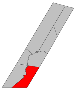 Location within Sunbury County, New Brunswick | |
| Country |
|
| Province |
|
| County | Sunbury County |
| Established | 1869 |
| Area[1] | |
| • Land | 342.45 km2 (132.22 sq mi) |
| Population (2011)[1] | |
| • Total | 926 |
| • Density | 2.7/km2 (7/sq mi) |
| • Pop 2006-2011 |
|
| • Dwellings | 388 |
| Time zone | AST (UTC-4) |
| • Summer (DST) | ADT (UTC-3) |
Blissville is a Canadian parish in Sunbury County, New Brunswick.[2]
History
Blissville Parish was set off from Burton Parish and Lincoln Parish in 1834: Blissville Parish included Gladstone Parish until 1874: named for John Murray Bliss (1771-1834) who was an administrator of the New Brunswick government.
Delineation
Blissville Parish is defined in the Territorial Division Act[3] as being bounded:
South and southeast by the County lines; northeast by Burton Parish, and west and northwest by a line beginning on the western bank or shore of the Oromocto River, where the dividing line between the Parishes of Blissville and Burton intersects the same, thence following the various courses of the said river up stream to the main forks; thence following the various courses of the south branch of the said river up stream to the northeast angle of lot thirteen, granted to Nathaniel Hubbard, about one mile above the forks; thence westerly along the northern line of said lot to the northwest angle thereof; thence southerly along the rear line of said lots fronting on western side of said south branch to the old Block House Road;[lower-alpha 1] and thence south sixty-seven degrees west to the Charlotte County line.
Governance
The entire parish forms the local service district of the parish of Blissville, which was established in 1966. It was originally assessed for fire protection, with recreational and sports facilities added in 2008. First aid and ambulance services was added in 1978 and officially removed 2008.
Communities
Parish population total does not include incorporated municipalities (in bold):
|
|
Bodies of water & Islands
This is a list of rivers, lakes, streams, creeks, marshes and Islands that are at least partially in this parish
Demographics
PopulationPopulation trend[4]
|
LanguageMother tongue language (2006)[5]
|
Access Routes
Highways and numbered routes that run through the parish, including external routes that start or finish at the parish limits:[6]
See also
Footnotes
- ↑ Which does not appear on any modern maps.
References
- 1 2 2011 Statistics Canada Census Profile: Blissville Parish, New Brunswick
- ↑ New Brunswick Provincial Archives - Blissville Parish
- ↑ "Territorial Division Act (R.S.N.B. 1973, c. T-3)". Government of New Brunswick website. Retrieved 17 August 2016.
- ↑ Statistics Canada: 2001, 2006 census
- ↑ Profile: Clarendon Parish, New Brunswick
- ↑ Atlantic Canada Back Road Atlas ISBN 978-1-55368-618-7
 |
Lincoln Parish | Burton Parish | Gagetown Parish (Queens County) | |
| Gladstone Parish | |
Petersville Parish (Queens County) | ||
| ||||
| | ||||
| Clarendon Parish (Charlotte County) |
| Subdivisions | |
|---|---|
| Cities | |
| Counties | |
| |
Coordinates: 45°37′59″N 66°34′59″W / 45.633°N 66.583°W