Victoria County, New Brunswick
| Victoria | |
|---|---|
| County | |
 Location within New Brunswick. | |
| Country |
|
| Province |
|
| Established | 1844 |
| Shire town | Perth-Andover |
| Area[1] | |
| • Land | 5,503.93 km2 (2,125.08 sq mi) |
| Population (2011)[1] | |
| • Total | 19,921 |
| • Density | 3.6/km2 (9/sq mi) |
| • Pop 2006-2011 |
|
| • Dwellings | 9,342 |
| Time zone | AST (UTC-4) |
| • Summer (DST) | ADT (UTC-3) |
| Area code(s) | 506 |
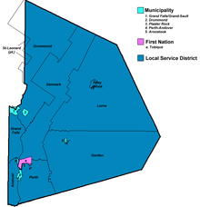
Map of municipal government units in Victoria County.
| Wikimedia Commons has media related to Victoria County, New Brunswick. |
Victoria County (2011 population 19,921) is located in northwestern New Brunswick, Canada. Farming, especially of potatoes, is the major industry in the county.
Census subdivisions
Communities
There are five municipalities within Victoria County (listed by 2011 population):[1]
| Official Name | Designation | Area km2 | Population | Parish |
|---|---|---|---|---|
| Grand Falls/Grand-Sault | Town | 18.06 | 5,706 | Grand Falls |
| Perth-Andover | Village | 8.89 | 1,778 | Perth |
| Plaster Rock | Village | 3.09 | 1,135 | Gordon |
| Drummond | Village | 8.91 | 775 | Drummond |
| Aroostook | Village | 2.24 | 351 | Andover |
First Nations
There is one First Nations reserve in Victoria County (listed by 2011 population):[1]
| Official Name | Designation | Area km2 | Pop 2011 | Parish |
|---|---|---|---|---|
| Tobique 20 | Reserve | 24.94 | 1,039 | Perth |
Parishes
The county is subdivided into seven parishes (listed by 2011 population):[1]
| Official Name | Area km2 | Pop 2011 | Municipalities | Unincorporated communities |
|---|---|---|---|---|
| Drummond | 1,014.90 | 2,250 | Drummond (village) | Black Brook / Burgess Settlement / Caldwell / Canton / Davis Mill / Desjardins Road / Ennishone / Hazen / Hennigar Corner / Jardine Brook / McManus Siding / Price Road / Quatre-Coins / Violette Brook / Violette Station |
| Denmark | 750.51 | 1,592 | Foley Brook / Lake Edward / Lerwick / New Denmark / North Tilley / Salmonhurst Corner / South Tilley | |
| Gordon | 1,430.98 | 1,567 | Plaster Rock (village) | Anderson Road / Anfield / Arthurette / Birch Ridge / Bluebell Station / Crombie Settlement / Hazeldean / Maple View / North View / O'Dell / Picadilly / Red Rapids / Rowena / Sisson Ridge / St. Almo / Three Brooks / Wapske / Weaver |
| Grand Falls | 158.43 | 1,172 | Grand Falls/Grand-Sault (town) | Argosy / California Settlement / Costigan / Four Falls / Gillespie Settlement / Grand Falls Portage / Kelly Road / Lower California / Lower Portage / McCluskey / Morrell Siding / Undine / Upper California |
| Perth | 318.06 | 1,096 | Perth-Andover (village) Tobique 20 (reserve) |
Beech Glen / Beech Glen Road / Bon Accord / Caldwell Brook / Currie / Gladwyn / Hillside / Inman / Kilburn / Kincardine / Lower Kintore / Lower Perth / Maliseet / Muniac / Quaker Brook / Red Rapids / Rowena / Tobique Narrows / Upper Kintore |
| Andover | 123.57 | 942 | Aroostook (village) | Bairdsville / Beaconsfield / Carlingford / Dover Hill / Hillandale / Maliseet / River De Chute / Tinker / Turner Settlement |
| Lorne | 1,640.29 | 518 | Blue Mountain Bend / Burntland Brook / Enterprise / Everett / Haley Brook / Lorne / Mapleview / Nictau / North View / Oxbow / Riley Brook / Sisson Brook / Two Brooks / Victoria |
Demographics
Population
| Canada census – Victoria County, New Brunswick community profile | |||
|---|---|---|---|
| 2011 | 2006 | 2001 | |
| Population: | 19,921 (-2.0% from 2006) | 20,319 (-4.0% from 2001) | 21,172 (-3.5% from 1996) |
| Land area: | 5,503.93 km2 (2,125.08 sq mi) | 5,502.85 km2 (2,124.66 sq mi) | 5,502.87 km2 (2,124.67 sq mi) |
| Population density: | 3.6/km2 (9.3/sq mi) | 3.7/km2 (9.6/sq mi) | 3.8/km2 (9.8/sq mi) |
| Median age: | 45.2 (M: 44.4, F: 45.9) | 41.9 (M: 41.2, F: 42.5) | 38.3 (M: 37.3, F: 39.3) |
| Total private dwellings: | 9,342 | 9,163 | 9,042 |
| Median household income: | $41,435 | $38,403 | $33,490 |
| References: 2011[1] 2006[2] 2001[3] | |||
| Historical Census Data - Victoria County, New Brunswick[4] | ||||||||||||||||||||||||||
|---|---|---|---|---|---|---|---|---|---|---|---|---|---|---|---|---|---|---|---|---|---|---|---|---|---|---|
|
|
| ||||||||||||||||||||||||
Language
| Canada Census Mother Tongue - Victoria County, New Brunswick[4] | ||||||||||||||||||
|---|---|---|---|---|---|---|---|---|---|---|---|---|---|---|---|---|---|---|
| Census | Total | English |
French |
English & French |
Other | |||||||||||||
| Year | Responses | Count | Trend | Pop % | Count | Trend | Pop % | Count | Trend | Pop % | Count | Trend | Pop % | |||||
| 2011 |
19,630 |
10,740 | |
54.71% | 8,405 | |
42.82% | 190 | |
0.97% | 295 | |
1.50% | |||||
| 2006 |
20,070 |
10,760 | |
53.61% | 8,590 | |
42.80% | 100 | |
0.50% | 620 | |
3.09% | |||||
| 2001 |
20,915 |
11,290 | |
53.98% | 8,905 | |
42.58% | 195 | |
0.93% | 525 | |
2.51% | |||||
| 1996 |
21,675 |
12,040 | n/a | 55.55% | 8,980 | n/a | 41.43% | 225 | n/a | 1.04% | 430 | n/a | 1.98% | |||||
|
Ethnic Groups (2006)[5]
|
Religious make-up (2001)[6]
|
Access Routes
Highways and numbered routes that run through the county, including external routes that start or finish at the county limits:[7]
|
|
Protected areas and attractions
Notable people
Main article: List of people from Victoria County, New Brunswick
See also
References
- 1 2 3 4 5 6 "2011 Community Profiles". Canada 2011 Census. Statistics Canada. July 5, 2013. Retrieved 2014-03-26.
- ↑ "2006 Community Profiles". Canada 2006 Census. Statistics Canada. March 30, 2011. Retrieved 2014-03-26.
- ↑ "2001 Community Profiles". Canada 2001 Census. Statistics Canada. February 17, 2012. Retrieved 2014-03-26.
- 1 2 Statistics Canada: 1996, 2001, 2006, 2011 census
- ↑ 2006 Statistics Canada Community Profile: Victoria County, New Brunswick
- ↑ Religious make-up, for Victoria County, 2001 census - 100% data
- ↑ Atlantic Canada Back Road Atlas ISBN 978-1-55368-618-7
External links
 |
Madawaska County | Restigouche County | | |
| |
|
Northumberland County | ||
| ||||
| | ||||
| Carleton County | York County |
| Subdivisions | |
|---|---|
| Cities | |
| Counties | |
| |
Coordinates: 47°4′30.7″N 67°19′45.8″W / 47.075194°N 67.329389°W
This article is issued from Wikipedia - version of the 8/25/2016. The text is available under the Creative Commons Attribution/Share Alike but additional terms may apply for the media files.