Blue Ridge, Georgia
| Blue Ridge, Georgia | |
|---|---|
| City | |
|
Downtown Blue Ridge | |
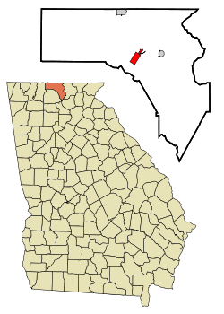 Location in Fannin County and the state of Georgia | |
| Coordinates: 34°52′6″N 84°19′16″W / 34.86833°N 84.32111°WCoordinates: 34°52′6″N 84°19′16″W / 34.86833°N 84.32111°W | |
| Country | United States |
| State | Georgia |
| County | Fannin |
| Area | |
| • Total | 2.4 sq mi (6.2 km2) |
| • Land | 2.4 sq mi (6.2 km2) |
| • Water | 0 sq mi (0 km2) |
| Elevation | 1,762 ft (537 m) |
| Population (2010) | |
| • Total | 1,290 |
| • Density | 542/sq mi (209.2/km2) |
| Time zone | Eastern (EST) (UTC-5) |
| • Summer (DST) | EDT (UTC-4) |
| ZIP code | 30513 |
| Area code(s) | 706/762 |
| FIPS code | 13-08928[1] |
| GNIS feature ID | 0331197[2] |
| Website |
www |

Blue Ridge is a city in Fannin County, Georgia, United States. As of the 2010 census, the city had a population of 1,290.[3] The city is the county seat of Fannin County.[4]
History
The Cherokee people controlled the area today known as Fannin County when the first white settlements appeared. Unlike much of the rest of Georgia, Fannin County's first settlers did not come from the east, but from the north. Written accounts date these earliest settlements to 1790.
Crossing the Appalachian Mountains to Fort Loudoun (now Tennessee), the first settlers followed the Tennessee River south, where they took the Ocoee-Toccoa River to the wide, fertile river valley that separates the Cohuttas and the Blue Ridge Mountains in Fannin County. Coastal Georgians began to push the Cherokee farther west, and this land was surrendered by the Cherokee in 1835, under the terms of the Treaty of New Echota. In 1838 the Cherokee were forced to leave in a travesty today known as the Trail of Tears.
Fannin County was created in 1854 from portions of Union County and Gilmer, with Morganton as the first county seat. Col. James Fannin, for whom the county is named, was a hero in the Texas War for Independence. Ordered by Sam Houston to pull back from a fortified position in Goliad, Fannin was surrounded by forces under the command of Gen. José de Urrea in the Battle of Coleto. Fannin surrendered his force of about 400 men, who later were massacred.
According to historic records at the County Historic Cabin near Blue Ridge about early business in Fannin, Appalachian farmers in this area grew products that had to be taken to a mill and "cracked" before use, hence the term "cracker" was frequently applied to them.
Agriculture, and the businesses supporting it, have been a mainstay of the Fannin County economy since its earliest days. A push for diversification at the start of the twentieth century greatly expanded the types of crops raised. From the mid-1800s until the start of the nineteenth century, mining also contributed to the economy, as did lumber from 1900 until World War II.
The Marietta and North Georgia Railroad made an economic decision to avoid Fannin's county seat, Morganton, instead building the railroad through the long, relatively flat Toccoa River valley. Col. Mike McKinney founded the town of Blue Ridge in 1886 along the route of the railroad. When the railroad arrived in Fannin County, it gave the county a market for its agricultural products. What had taken days to deliver now took hours. In the early 1920s construction began on U.S. Highway 76, further increasing access to this once remote area.
Tourism picked up with the completion of the railroad to Blue Ridge, but this boon was short-lived. In the 1950s, tourism surged again in the county. With the completion of the Georgia Mountain Parkway in 1986 this trickle became a flood.
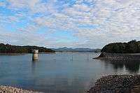
Much of the land in Fannin County is under management of the U.S. Forest Service. Beginning as the Cherokee and later the Georgia National Forest, today's Chattahoochee National Forest is a gem in the crown of Fannin County. Managed for use by all visitors, the land creates jobs, offers recreational opportunities, and preserves ecologically sensitive areas from overuse.[5]
Geography
The city of Blue Ridge is located south of the center of Fannin County at 34°52′6″N 84°19′16″W / 34.86833°N 84.32111°W (34.868344, -84.320991).[6] The city sits on the divide between the Tennessee River watershed to the north (via the Toccoa River) and the Alabama River to the south (via Crooked Log Creek, the Ellijay River, and several downstream rivers).
U.S. Route 76 passes through the west side of the city, leading east 22 miles (35 km) to Blairsville and southwest 15 miles (24 km) to Ellijay. Georgia State Route 5 leads north from Blue Ridge 10 miles (16 km) to McCaysville at the Tennessee line.
According to the United States Census Bureau, the city has a total area of 2.4 square miles (6.2 km2), all of it land.[7]
Climate
| Climate data for Blue Ridge, Georgia | |||||||||||||
|---|---|---|---|---|---|---|---|---|---|---|---|---|---|
| Month | Jan | Feb | Mar | Apr | May | Jun | Jul | Aug | Sep | Oct | Nov | Dec | Year |
| Record high °F (°C) | 74 (23) |
78 (26) |
85 (29) |
91 (33) |
94 (34) |
100 (38) |
103 (39) |
101 (38) |
98 (37) |
92 (33) |
83 (28) |
76 (24) |
103 (39) |
| Average high °F (°C) | 50 (10) |
54 (12) |
61 (16) |
71 (22) |
78 (26) |
84 (29) |
88 (31) |
87 (31) |
81 (27) |
72 (22) |
62 (17) |
52 (11) |
70 (21.2) |
| Daily mean °F (°C) | 38 (3) |
41 (5) |
48 (9) |
56 (13) |
64 (18) |
71 (22) |
76 (24) |
75 (24) |
68 (20) |
57 (14) |
48 (9) |
40 (4) |
56.8 (13.8) |
| Average low °F (°C) | 26 (−3) |
28 (−2) |
34 (1) |
40 (4) |
49 (9) |
58 (14) |
63 (17) |
62 (17) |
54 (12) |
42 (6) |
34 (1) |
28 (−2) |
43.2 (6.2) |
| Record low °F (°C) | −16 (−27) |
−5 (−21) |
2 (−17) |
17 (−8) |
29 (−2) |
37 (3) |
47 (8) |
46 (8) |
30 (−1) |
19 (−7) |
−1 (−18) |
−8 (−22) |
−16 (−27) |
| Average precipitation inches (mm) | 5.8 (147) |
5.5 (140) |
6.4 (163) |
4.9 (124) |
5.0 (127) |
4.6 (117) |
5.4 (137) |
4.8 (122) |
4.5 (114) |
3.3 (84) |
5.0 (127) |
5.0 (127) |
60.2 (1,529) |
| Source: [8] | |||||||||||||
Demographics
| Historical population | |||
|---|---|---|---|
| Census | Pop. | %± | |
| 1890 | 264 | — | |
| 1900 | 1,148 | 334.8% | |
| 1910 | 898 | −21.8% | |
| 1920 | 904 | 0.7% | |
| 1930 | 1,190 | 31.6% | |
| 1940 | 1,362 | 14.5% | |
| 1950 | 1,718 | 26.1% | |
| 1960 | 1,406 | −18.2% | |
| 1970 | 1,602 | 13.9% | |
| 1980 | 1,376 | −14.1% | |
| 1990 | 1,336 | −2.9% | |
| 2000 | 1,210 | −9.4% | |
| 2010 | 1,290 | 6.6% | |
| Est. 2015 | 1,286 | [9] | −0.3% |
As of the 2010 United States Census, there were 1,290 people residing in the city. The racial makeup of the city was 92.1% White, 1.2% Black, 0.2% Native American, 0.5% Asian, 0.7% from some other race and 0.9% from two or more races. 4.5% were Hispanic or Latino of any race.
As of the census[1] of 2000, there were 1,210 people, 553 households, and 319 families residing in the city. The population density was 557.2 people per square mile (215.3/km²). There were 631 housing units at an average density of 290.6 per square mile (112.3/km²). The racial makeup of the city was 98.26% White, 0.41% African American, 0.41% Asian, 0.17% from other races, and 0.74% from two or more races. Hispanic or Latino of any race were 0.83% of the population.
There were 553 households out of which 25.1% had children under the age of 18 living with them, 38.9% were married couples living together, 15.9% had a female householder with no husband present, and 42.3% were non-families. 38.2% of all households were made up of individuals and 19.7% had someone living alone who was 65 years of age or older. The average household size was 2.14 and the average family size was 2.81.
In the city the population was spread out with 22.3% under the age of 18, 9.8% from 18 to 24, 23.9% from 25 to 44, 25.2% from 45 to 64, and 18.8% who were 65 years of age or older. The median age was 39 years. For every 100 females there were 83.3 males. For every 100 females age 18 and over, there were 80.8 males.
The median income for a household in the city was $28,214, and the median income for a family was $35,259. Males had a median income of $25,859 versus $17,941 for females.
The per capita income for the city was $16,149. About 13.7% of families and 17.0% of the population were below the poverty line, including 22.9% of those under age 18 and 16.6% of those age 65 or over.
Education
Fannin County School District
The Fannin County School District holds pre-school to grade twelve, and consists of three elementary schools, a middle school, and a high school.[11] The district has 179 full-time teachers and more than 3,212 students.[12]
- Blue Ridge Elementary School
- East Fannin Elementary School
- West Fannin Elementary School
- Fannin County Middle School
- Fannin County High School
Cinema
The town has one of the few drive-in theaters in North Georgia, the Swan.
Notable people
- Kirk Kirkpatrick, CEO, executive
- Lake Underwood, entrepreneur, inventor, and racecar owner and driver
- Mark Wills, country singer
- Chipper Jones, MLB player for the Atlanta Braves has a home in Blue Ridge.
References
- 1 2 "American FactFinder". United States Census Bureau. Archived from the original on 2013-09-11. Retrieved 2008-01-31.
- ↑ "US Board on Geographic Names". United States Geological Survey. 2007-10-25. Retrieved 2008-01-31.
- ↑ http://factfinder2.census.gov/faces/tableservices/jsf/pages/productview.xhtml?pid=DEC_10_SF1_GCTP2.ST13&prodType=table
- ↑ "Find a County". National Association of Counties. Archived from the original on 2011-05-31. Retrieved 2011-06-07.
- ↑ http://www.blueridgemountains.com/history.html
- ↑ "US Gazetteer files: 2010, 2000, and 1990". United States Census Bureau. 2011-02-12. Retrieved 2011-04-23.
- ↑ "Geographic Identifiers: 2010 Census Summary File 1 (G001), Blue Ridge city, Georgia". American FactFinder. U.S. Census Bureau. Retrieved April 26, 2016.
- ↑ "Average Monthly/Record Temperatures". The Weather Channel. Retrieved 6 September 2015.
- ↑ "Annual Estimates of the Resident Population for Incorporated Places: April 1, 2010 to July 1, 2015". Retrieved July 2, 2016.
- ↑ "Census of Population and Housing". Census.gov. Archived from the original on May 11, 2015. Retrieved June 4, 2015.
- ↑ Georgia Board of Education, Retrieved June 9, 2010.
- ↑ School Stats, Retrieved June 9, 2010.
External links
| Wikivoyage has a travel guide for Blue Ridge (Georgia). |
- City of Blue Ridge official website
- Fannin County Chamber of Commerce
- The News Observer
- Blue Ridge Scenic Railway
Municipalities and communities of Fannin County, Georgia, United States | ||
|---|---|---|
| Cities | 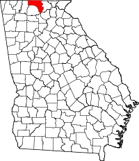 | |
| CDPs | ||
| Unincorporated community | ||