Boalsburg, Pennsylvania
| Boalsburg, Pennsylvania | |
|---|---|
| Census-designated place | |
|
Downtown Boalsburg | |
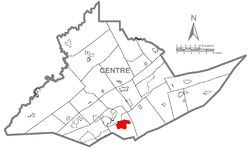 Location within Centre County | |
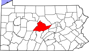
 Boalsburg Location within the state of Pennsylvania | |
| Coordinates: 40°46′58″N 77°47′13″W / 40.78278°N 77.78694°WCoordinates: 40°46′58″N 77°47′13″W / 40.78278°N 77.78694°W | |
| Country | United States |
| State | Pennsylvania |
| County | Centre |
| Townships | Harris, College |
| Area | |
| • Total | 5.8 sq mi (15.0 km2) |
| • Land | 5.8 sq mi (15.0 km2) |
| • Water | 0.0 sq mi (0.0 km2) |
| Elevation | 1,105 ft (337 m) |
| Population (2010) | |
| • Total | 3,722 |
| • Density | 642/sq mi (248.0/km2) |
| Time zone | Eastern (EST) (UTC-5) |
| • Summer (DST) | EDT (UTC-4) |
| ZIP code | 16827 |
| Area code(s) | 814 |

Boalsburg is an unincorporated community and census-designated place (CDP) in Harris Township, Centre County, Pennsylvania, United States. It is part of the State College, Pennsylvania Metropolitan Statistical Area. The population was 3,722 at the 2010 census.[1] The village claims to be the birthplace of Memorial Day.
History
The name "Boalsburg" comes from the Boal family who settled the region. The fourth generation of the Boal family, Col. Theodore Davis Boal, married a descendant of Christopher Columbus and brought the Columbus Chapel to the Boal Mansion from Spain in 1909 including an admiral's desk that belonged to Columbus himself. The Columbus Chapel and Boal Mansion Museum are open to the public. Boalsburg originally was on the main road for travelers from Philadelphia to Pittsburgh, with the David Boal tavern that housed travelers still standing today. Boalsburg is home to the Pennsylvania Military Museum, as well as the headquarters of the Civil War reenacting unit, 3rd Pennsylvania Light Artillery Battery B.
The Boalsburg Historic District and Hill House were added to the National Register of Historic Places in 1977. The Boal Mansion was added the following year.[2]
Geography
Boalsburg is located in southern Centre County at 40°46′58″N 77°47′13″W / 40.78278°N 77.78694°W (40.782670, -77.786899).[3] It occupies the center and northern parts of Harris Township and extends northwest slightly into College Township.
According to the United States Census Bureau, the CDP has a total area of 5.8 square miles (15.0 km2), all of it land.[1] It is centered upon Pennsylvania Route 45 and Business U.S. Route 322. 322 begins as the Mount Nittany Expressway in the CDP and travels northwest from Boalsburg, bypassing State College to the east and north, while Business 322 proceeds into the center of State College, 4 miles (6 km) northwest of Boalsburg, as Atherton Street. In the other direction US 322 leads east and then south 27 miles (43 km) to Lewistown.
Spring Creek flows northward through Boalsburg towards Bald Eagle Creek, a tributary of the West Branch Susquehanna River. The Tussey Mountain Ski Area is located on the eastern edge of Boalsburg.
Demographics
As of the census[4] of 2010, there were 3,722 people, 1,523 households, and 1,076 families residing in the CDP. The population density was 602.5 people per square mile (232.6/km²). There were 1,613 housing units at an average density of 260.2/sq mi (100.5/km²). The racial makeup of the CDP was 93.5% White, 2.2% Black or African American, 0.1% Native American, 2.0% Asian, 0.4% from other races, and 1.7% from two or more races. Hispanic or Latino of any race were 1.6% of the population.
There were 1,523 households, out of which 31.7% had children under the age of 18 living with them, 57.8% were married couples living together, 3.5% had a male householder with no wife present, 9.4% had a female householder with no husband present, and 29.3% were non-families. 23.4% of all households were made up of individuals, and 8.0% had someone living alone who was 65 years of age or older. The average household size was 2.44 and the average family size was 2.89.
In the CDP the population was spread out, with 23.3% under the age of 18, 7.4% from 18 to 24, 22.6% from 25 to 44, 32.4% from 45 to 64, and 14.3% who were 65 years of age or older. The median age was 43 years. For every 100 females there were 91.9 males. For every 100 females age 18 and over, there were 89.1 males.
The median income for a household in the CDP was $62,289, and the median income for a family was $70,612. The per capita income for the CDP was $32,676. About 4.7% of families and 6.0% of the population were below the poverty line, including 11.6% of those under age 18 and 2.6% of those age 65 or over.
References
- 1 2 "Geographic Identifiers: 2010 Census Summary File 1 (G001): Boalsburg CDP, Pennsylvania". U.S. Census Bureau, American Factfinder. Retrieved April 14, 2015.
- ↑ National Park Service (2010-07-09). "National Register Information System". National Register of Historic Places. National Park Service.
- ↑ "US Gazetteer files: 2010, 2000, and 1990". United States Census Bureau. 2011-02-12. Retrieved 2011-04-23.
- ↑ "American FactFinder". United States Census Bureau. Archived from the original on 2013-09-11. Retrieved 2008-01-31.
| Wikimedia Commons has media related to Boalsburg, Pennsylvania. |
External links
- Boalsburg community website
- Boalsburg Village, another community website
- Boalsburg Central, third community website
- Parks in Boalsburg
- Boal Museum
 |
Oak Hall, Dalevue, Lemont | Dale Summit | Linden Hall | |
| Panorama Village, Harris Acres, State College | |
Tusseyville | ||
| ||||
| | ||||
| Shingletown | Harris Township | Harris Township |