Bor, South Sudan
| City of Bor | |
|---|---|
|
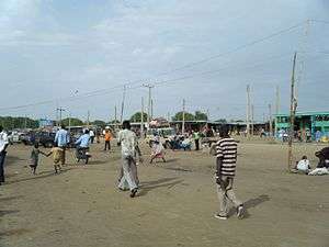
Merol Market in Bor Town (2010). | |
 City of Bor Location in South Sudan | |
| Coordinates: 6°12′45″N 31°33′39″E / 6.21250°N 31.56083°ECoordinates: 6°12′45″N 31°33′39″E / 6.21250°N 31.56083°E | |
| Country |
|
| State | Jonglei |
| City Mayor | His Lordship Akim Ajieth Buny |
| Elevation | 407 m (1,335 ft) |
| Population (2010) | |
| • Total | 315,351 |
| Time zone | EAT (UTC+3) |
| Climate | Aw |
Bor is the capital of Jonglei State in South Sudan. Bor is located in former Bor county (composed of Bor South, Bor East, Bor Central, Bor West and Bor North counties.)
History
Bor is of historical importance to the people of South Sudan. It was in Malek, a small settlement about 19 kilometres (12 mi) south of Bor, that one of the first modern Christian missions in present-day South Sudan was established by Archibald Shaw in December 1905. Bor became the first area to host a Church Missionary Society station in 1905.[1]
Malek was turned into a missionary stronghold in the Upper Nile Region. Shaw opened the first primary school in Malek. This school produced the first indigenous Anglican bishop to be consecrated in Dinkaland, Rt. Rev. Daniel Deng Atong, followed the Nikonora Achiek Deng Ariir. John Aruor became the first legend to be baptized in 1916 in Bor.[2]
Bor became an administrative centre under the Anglo-Egyptian Sudan (1899–1956) for the Dinka people. Bor is the epicenter of the Second Sudanese Civil War. Dr. John Garang De Mabior, an officer in the Sudanese Army led a revolt in the town of Bor, in May 1983, leading to the birth of the Sudan People's Liberation Movement and Sudan People's Liberation Army (SPLM/SPLA). Bor was also the scene of the 1991 Bor massacre, where approximately 20000 people were killed. Eventually South Sudan became independent on 9 July 2011.
Following the 2013 South Sudanese coup d'état attempt, Bor was contested in several weeks of combat between the national army and rebels led by Riek Machar.[3] A portion of the Nuer White Army joined the fighting as well.[4]
Geography
The town of Mading-Bor is Jonglei State's capital city, in central South Sudan, approximately 190 kilometres (120 mi), by road, north of Juba, the capital and largest city in the country.[5] The town is located on the east bank of the White Nile.
Climate
Köppen-Geiger climate classification system classifies its climate as tropical wet and dry (Aw).[6]
| Climate data for Bor, South Sudan | |||||||||||||
|---|---|---|---|---|---|---|---|---|---|---|---|---|---|
| Month | Jan | Feb | Mar | Apr | May | Jun | Jul | Aug | Sep | Oct | Nov | Dec | Year |
| Average high °C (°F) | 36 (97) |
36.6 (97.9) |
36.6 (97.9) |
34.9 (94.8) |
33 (91) |
31.8 (89.2) |
30.3 (86.5) |
30.5 (86.9) |
31.5 (88.7) |
33.1 (91.6) |
34.4 (93.9) |
35.1 (95.2) |
33.65 (92.55) |
| Daily mean °C (°F) | 27.9 (82.2) |
28.6 (83.5) |
29.6 (85.3) |
28.6 (83.5) |
27.4 (81.3) |
26.6 (79.9) |
25.5 (77.9) |
25.5 (77.9) |
26.2 (79.2) |
27.2 (81) |
27.6 (81.7) |
27.3 (81.1) |
27.33 (81.21) |
| Average low °C (°F) | 19.9 (67.8) |
20.6 (69.1) |
22.6 (72.7) |
22.4 (72.3) |
21.8 (71.2) |
21.5 (70.7) |
20.8 (69.4) |
20.6 (69.1) |
21 (70) |
21.3 (70.3) |
20.9 (69.6) |
19.5 (67.1) |
21.08 (69.94) |
| Average precipitation mm (inches) | 2 (0.08) |
5 (0.2) |
32 (1.26) |
80 (3.15) |
119 (4.69) |
112 (4.41) |
126 (4.96) |
150 (5.91) |
124 (4.88) |
105 (4.13) |
32 (1.26) |
4 (0.16) |
891 (35.09) |
| Source: Climate-Data.org (altitude: 430m)[6] | |||||||||||||
Population
In 2006 the population of the town of Bor was estimated at about 138,800.[7]
Economy
Kenya Commercial Bank (South Sudan) maintains a branch in Bor.[8]
Education
The John Garang Memorial University of Science and Technology, one of the seven public universities in the country, is located in Bor. The university is named after John Garang de Mabior (June 23, 1945 – July 30, 2005). Garang is considered the founder of modern South Sudan having led the South Sudanese movement Sudan People's Liberation Army/Movement. He signed the Comprehensive Peace Agreement in 2005, an event which culminated in the independence of South Sudan in 2011. Garang died in a helicopter crash in 2005, 21 days following his swearing in as the first Vice President of Sudan and President of the Autonomous South Sudan. The John Garang Memorial University of Science and Technology was founded by the former governor of Jonglei State, Mr. Philip Thon Leek.
Transportation
Bor is also served by Bor Airport, in addition to river traffic on the White Nile and three major roads that lead out of town.
See also
- Bor Airport (South Sudan)
- White Nile
- Bor Municipal Council
- Jonglei State
References
- ↑ Tuttle, Brendan (2015). "South Sudan". In Riggs, Thomas. Worldmark Encyclopedia of Religious Practices: Religions and Denominations. Global Issues In Context. 4 (2nd ed.). Gale. pp. 225–232. Retrieved June 10, 2016.
- ↑ Guarak, Mawut Achiecque Mach (2011). Integration and Fragmentation of the Sudan: An African Renaissance. Bloomington: AuthorHouse. p. 319. ISBN 9781456723576.
- ↑ "South Sudan rebels control Jonglei state capital, says military". The Guardian. 19 December 2013. Retrieved 21 December 2013.
- ↑ Straziuso, Jason (30 December 2013). "South Sudan: 'White Army' militia marches to fight". West Hawaii Today. Retrieved 1 January 2014.
- ↑ "Map Showing Bor And Juba With Distance Marker". Distancecalculator.globefeed.com. Retrieved 2013-12-27.
- 1 2 "Climate: Bor - Climate graph, Temperature graph, Climate table". Climate-Data.org. Retrieved 2013-12-26.
- ↑ "Estimated Population of Bor, South Sudan". Tiptopglobe.com. Retrieved 2013-12-27.
- ↑ Branches of KCB South Sudan