Border Junction, Wyoming
| Border Junction, Wyoming | |
|---|---|
 Border Junction, Wyoming  Border Junction, Wyoming Location of Border Junction in Wyoming | |
| Coordinates: 42°12′48″N 111°02′33″W / 42.2132657°N 111.0424128°WCoordinates: 42°12′48″N 111°02′33″W / 42.2132657°N 111.0424128°W | |
| Country | United States of America |
| State | Wyoming |
| County | Lincoln |
| Elevation[1] | 6,115 ft (1,864 m) |
| Border Junction | |
|---|---|
| Border, Wyoming | |
| Location | |
| Lincoln County, Wyoming | |
| Roads at junction: |
Lincoln County Road 134 |
| Construction | |
| Type: | intersection |
Border Junction or Border is a populated place and road intersection in the far western part of Lincoln County, Wyoming.[1] US Route 30 is the major road, which leads northwest to Montpelier, Idaho, in Bear Lake County, and southeast to Cokeville, Wyoming. Wyoming Highway 89 runs north toward US Route 89, and southeast concurrently with US 30. Lincoln County Road 134 runs briefly south toward some homes and ranches. The Union Pacific Railroad passes Border Junction in the direction of Rock Springs to the east and Pocatello, Idaho, to the west.[2]
Geography
Border Junction lies at 6,115 feet (1,864 m) elevation[1] about 0.25 miles (0.40 km) east of the Wyoming-Idaho state line. It is in the Thomas Fork valley of the Bear River, just west of the Sublette Mountains (and Sublette Mountain, the highest summit of the Southern Wyoming Overthrust Belt).[2]
In September and October, around 5000 sandhill cranes migrate through the Border Junction area.[3]
History
The Overland Stage Route came north to Border Junction from Fort Bridger, along a path now through Cokeville, Sage, and Lyman.[2] Emigrants forded the Thomas Fork west of Border Junction by toll bridge, and wagon ruts are still visible on the ridges.[4]
References
- 1 2 3 U.S. Geological Survey Geographic Names Information System: Border Junction, Wyoming
- 1 2 3 Official State Highway Map of Wyoming (Map). Wyoming Department of Transportation. 2014.
- ↑ Johnsgard, Paul A. (2009). "A 2009 Supplement to Birds of the Rocky Mountains". Digital Commons @ University of Nebraska–Lincoln: xxv. Retrieved February 5, 2015.
- ↑ "Along the Snake River Plain through Idaho" (PDF). National Park Service: National Historic Trails, Auto Tour Route Interpretive Guide. October 2008. p. 45. Retrieved February 5, 2015.
Municipalities and communities of Lincoln County, Wyoming, United States | ||
|---|---|---|
| City | 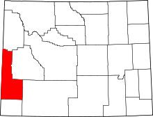 | |
| Towns | ||
| CDPs | ||
| Unincorporated communities | ||
| Footnotes | ‡This populated place also extends into Idaho | |