List of states and territories of the United States

The United States of America is a federal republic[1] consisting of 50 states (four of which use the term commonwealth rather than state in their full, legal state name[2][3][4][5]), a federal district (where the nation's seat of government—Washington, D.C.—is located), five major territories, and various possessions.[6][7] The 48 contiguous states and Washington, D.C., are in central North America between Canada and Mexico. The state of Alaska is in the northwestern part of North America (also bordering Canada) and the state of Hawaii is an archipelago in the mid-Pacific. The territories are scattered about the Pacific Ocean and the Caribbean Sea.
States are the primary subdivisions of the United States, and possess a number of powers and rights under the United States Constitution, such as regulating intrastate commerce, running elections, creating local governments, and ratifying constitutional amendments. Each state has its own constitution, grounded in republican principles, and government, consisting of three branches: executive, legislative, and judicial.[8] All states and their residents are represented in the federal Congress, a bicameral legislature consisting of the Senate and the House of Representatives. Each state is represented by two Senators, while Representatives are distributed among the states in proportion to the most recent constitutionally mandated decennial census.[9] Additionally, each state is entitled to select a number of electors to vote in the Electoral College, the body that elects the President of the United States, equal to the total of Representatives and Senators in Congress from that state.[10] Article IV, Section 3, Clause 1 of the Constitution grants to Congress the authority to admit new states into the Union. Since the establishment of the United States in 1776, the number of states has expanded from the original 13 to 50. Each new state has been admitted on an equal footing with the existing states.[11]
As provided by Article I, Section 8 of the Constitution, Congress exercises "exclusive jurisdiction" over the federal district, which is not part of any state. Prior to passage of the 1973 District of Columbia Home Rule Act, which devolved certain Congressional powers to an elected mayor and council, the district did not have an elected local government. Even so, Congress retains the right to review and overturn laws created by the council and intervene in local affairs.[12] As it is not a state, the district does not have representation in the Senate. However, since 1971, its residents have been represented in the House of Representatives by a non-voting delegate.[13] Additionally, since 1961, following ratification of the 23rd Amendment, the district has been entitled to select three electors to vote in the Electoral College.
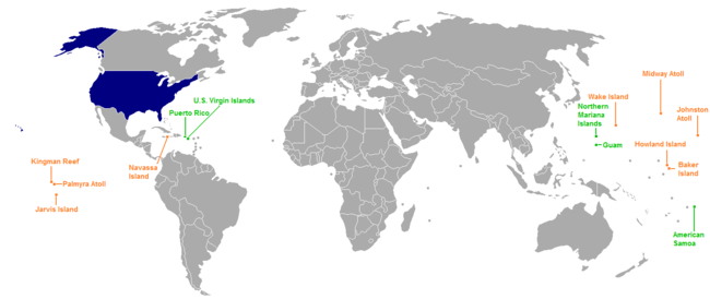
In addition to the 50 states and federal district, the United States has sovereignty over 14 territories. Five of them (American Samoa, Guam, the Northern Mariana Islands, Puerto Rico, and the U.S. Virgin Islands) have a permanent, nonmilitary population, while nine of them (the United States Minor Outlying Islands) do not. With the exception of Navassa Island, Puerto Rico, and the U.S. Virgin Islands, which are located in the Caribbean, all territories are located in the Pacific Ocean. Navassa Island is claimed by Haiti.[14] One territory, Palmyra Atoll, is considered to be incorporated, meaning the full body of the Constitution has been applied to it; the other territories are unincorporated, meaning the Constitution does not fully apply to them. Ten territories (the Minor Outlying Islands and American Samoa) are considered to be unorganized, meaning they have not had an Organic Act enacted by Congress; the four other territories are organized, meaning they have had an Organic Act that has been enacted by Congress. The five inhabited territories each have limited autonomy in addition to having territorial legislatures and governors, but residents cannot vote in federal elections.
California is the most populous state, with 38,332,521 residents (2013 estimate); Wyoming is the least populous, with an estimated 582,658 residents. The District of Columbia, with an estimated 646,449 residents as of 2012, has a higher population than the two least populous states (Wyoming and Vermont). The largest state by area is Alaska, encompassing 665,384 square miles (1,723,337 square kilometers), while the smallest is Rhode Island, encompassing 1,545 square miles (4,002 square kilometers). The first state to ratify the current Constitution was Delaware, which it did on December 7, 1787, while the newest state is Hawaii, which was admitted to the Union on August 21, 1959. The largest territory in terms of both population and size is Puerto Rico, with 3,725,789 residents as of the 2010 Census and a total area of 5,325 square miles (13,792 square kilometers).
The most recent entity to come under the sovereignty of the United States in its current form is the Northern Mariana Islands, which formally did so on November 3, 1986.[15]
States
The table below lists the 50 states, with their current capital, largest city, the date they ratified the constitution or were admitted to the Union, population and area data, and number of representative(s) in the United States House of Representatives (Each state is entitled to at least one representative. Current law limits the number of representatives to 435, which are then apportioned among states every ten years according to their relative population. Each state is also entitled to two U.S. Senators.)
| State & Abbreviation | Cities | Statehood[upper-alpha 1] | Population | Area in mi2 (km2)[upper-alpha 2][16] | Rep(s) | ||||
|---|---|---|---|---|---|---|---|---|---|
| Capital | Largest[upper-alpha 3][17] | (2015 est)[18] | Total | Land | Water | ||||
| AL | Montgomery | Birmingham | Dec. 14, 1819 | 4,858,979 | 52,420 (135,767) | 50,645 (131,170) | 1,775 (4,597) | 7 | |
| AK | Juneau | Anchorage | Jan. 3, 1959 | 738,432 | 665,384 (1,723,337) | 570,641 (1,477,950) | 94,743 (245,383) | 1 | |
| AZ | Phoenix | Feb. 14, 1912 | 6,828,065 | 113,990 (295,233) | 113,594 (294,207) | 396 (1,026) | 9 | ||
| AR | Little Rock | Jun. 15, 1836 | 2,978,204 | 53,179 (137,733) | 52,035 (134,770) | 1,143 (2,960) | 4 | ||
| CA | Sacramento | Los Angeles | Sep. 9, 1850 | 39,144,818 | 163,695 (423,968) | 155,779 (403,466) | 7,916 (20,502) | 53 | |
| CO | Denver | Aug. 1, 1876 | 5,456,574 | 104,094 (269,602) | 103,642 (268,432) | 452 (1,171) | 7 | ||
| CT | Hartford | Bridgeport | Jan. 9, 1788 | 3,590,886 | 5,543 (14,356) | 4,842 (12,541) | 701 (1,816) | 5 | |
| DE | Dover | Wilmington | Dec. 7, 1787 | 945,934 | 2,489 (6,446) | 1,949 (5,048) | 540 (1,399) | 1 | |
| FL | Tallahassee | Jacksonville | Mar. 3, 1845 | 20,271,272 | 65,758 (170,312) | 53,625 (138,888) | 12,133 (31,424) | 27 | |
| GA | Atlanta | Jan. 2, 1788 | 10,214,860 | 59,425 (153,910) | 57,513 (148,958) | 1,912 (4,950) | 14 | ||
| HI | Honolulu | Aug. 21, 1959 | 1,431,603 | 10,932 (28,314) | 6,423 (16,635) | 4,509 (11,678) | 2 | ||
| ID | Boise | Jul. 3, 1890 | 1,654,930 | 83,569 (216,443) | 82,643 (214,044) | 926 (2,398) | 2 | ||
| IL | Springfield | Chicago | Dec. 3, 1818 | 12,859,995 | 57,914 (149,997) | 55,519 (143,794) | 2,395 (6,203) | 18 | |
| IN | Indianapolis | Dec. 11, 1816 | 6,619,680 | 36,420 (94,327) | 35,826 (92,789) | 593 (1,536) | 9 | ||
| IA | Des Moines | Dec. 28, 1846 | 3,123,899 | 56,273 (145,746) | 55,857 (144,669) | 416 (1,077) | 4 | ||
| KS | Topeka | Wichita | Jan. 29, 1861 | 2,911,641 | 82,278 (213,099) | 81,759 (211,755) | 520 (1,347) | 4 | |
| KY | Frankfort | Louisville | Jun. 1, 1792 | 4,425,092 | 40,408 (104,656) | 39,486 (102,268) | 921 (2,385) | 6 | |
| LA | Baton Rouge | New Orleans | Apr. 30, 1812 | 4,670,724 | 52,378 (135,658) | 43,204 (111,898) | 9,174 (23,761) | 6 | |
| ME | Augusta | Portland | Mar. 15, 1820 | 1,329,328 | 35,380 (91,634) | 30,843 (79,883) | 4,537 (11,751) | 2 | |
| MD | Annapolis | Baltimore | Apr. 28, 1788 | 6,006,401 | 12,406 (32,131) | 9,707 (25,141) | 2,699 (6,990) | 8 | |
| MA | Boston | Feb. 6, 1788 | 6,794,422 | 10,554 (27,335) | 7,800 (20,202) | 2,754 (7,133) | 9 | ||
| MI | Lansing | Detroit | Jan. 26, 1837 | 9,922,576 | 96,714 (250,488) | 56,539 (146,435) | 40,175 (104,053) | 14 | |
| MN | St. Paul | Minneapolis | May 11, 1858 | 5,489,594 | 86,936 (225,163) | 79,627 (206,233) | 7,309 (18,930) | 8 | |
| MS | Jackson | Dec. 10, 1817 | 2,992,333 | 48,432 (125,438) | 46,923 (121,530) | 1,509 (3,908) | 4 | ||
| MO | Jefferson City | Kansas City | Aug. 10, 1821 | 6,083,672 | 69,707 (180,540) | 68,742 (178,041) | 965 (2,499) | 8 | |
| MT | Helena | Billings | Nov. 8, 1889 | 1,032,949 | 147,040 (380,832) | 145,546 (376,962) | 1,494 (3,869) | 1 | |
| NE | Lincoln | Omaha | Mar. 1, 1867 | 1,896,190 | 77,348 (200,330) | 76,824 (198,973) | 524 (1,357) | 3 | |
| NV | Carson City | Las Vegas | Oct. 31, 1864 | 2,890,845 | 110,572 (286,380) | 109,781 (284,331) | 791 (2,049) | 4 | |
| NH | Concord | Manchester | Jun. 21, 1788 | 1,330,608 | 9,349 (24,214) | 8,953 (23,188) | 397 (1,028) | 2 | |
| NJ | Trenton | Newark | Dec. 18, 1787 | 8,958,013 | 8,723 (22,592) | 7,354 (19,047) | 1,368 (3,543) | 12 | |
| NM | Santa Fe | Albuquerque | Jan. 6, 1912 | 2,085,109 | 121,590 (314,917) | 121,298 (314,160) | 292 (756) | 3 | |
| NY | Albany | New York City | Jul. 26, 1788 | 19,795,791 | 54,555 (141,297) | 47,126 (122,056) | 7,429 (19,241) | 27 | |
| NC | Raleigh | Charlotte | Nov. 21, 1789 | 10,042,802 | 53,819 (139,391) | 48,618 (125,920) | 5,201 (13,471) | 13 | |
| ND | Bismarck | Fargo | Nov. 2, 1889 | 756,927 | 70,698 (183,107) | 69,001 (178,712) | 1,698 (4,398) | 1 | |
| OH | Columbus | Mar. 1, 1803 | 11,613,423 | 44,826 (116,099) | 40,861 (105,830) | 3,965 (10,269) | 16 | ||
| OK | Oklahoma City | Nov. 16, 1907 | 3,911,338 | 69,899 (181,038) | 68,595 (177,660) | 1,304 (3,377) | 5 | ||
| OR | Salem | Portland | Feb. 14, 1859 | 4,028,977 | 98,379 (254,800) | 95,988 (248,608) | 2,391 (6,193) | 5 | |
| PA | Harrisburg | Philadelphia | Dec. 12, 1787 | 12,802,503 | 46,054 (119,279) | 44,743 (115,884) | 1,312 (3,398) | 18 | |
| RI | Providence | May 29, 1790 | 1,056,298 | 1,545 (4,002) | 1,034 (2,678) | 511 (1,320) | 2 | ||
| SC | Columbia | May 23, 1788 | 4,896,146 | 32,020 (82,931) | 30,061 (77,858) | 1,960 (5,076) | 7 | ||
| SD | Pierre | Sioux Falls | Nov. 2, 1889 | 858,469 | 77,116 (199,730) | 75,811 (196,350) | 1,305 (3,380) | 1 | |
| TN | Nashville | Memphis | Jun. 1, 1796 | 6,600,299 | 42,144 (109,152) | 41,235 (106,798) | 909 (2,354) | 9 | |
| TX | Austin | Houston | Dec. 29, 1845 | 27,469,114 | 268,596 (695,660) | 261,232 (676,588) | 7,365 (19,075) | 36 | |
| UT | Salt Lake City | Jan. 4, 1896 | 2,995,919 | 84,897 (219,882) | 82,170 (212,819) | 2,727 (7,063) | 4 | ||
| VT | Montpelier | Burlington | Mar. 4, 1791 | 626,042 | 9,616 (24,905) | 9,217 (23,872) | 400 (1,036) | 1 | |
| VA | Richmond | Virginia Beach | Jun. 25, 1788 | 8,382,993 | 42,775 (110,787) | 39,490 (102,279) | 3,285 (8,508) | 11 | |
| WA | Olympia | Seattle | Nov. 11, 1889 | 7,170,351 | 71,298 (184,661) | 66,456 (172,120) | 4,842 (12,541) | 10 | |
| WV | Charleston | Jun. 20, 1863 | 1,844,128 | 24,230 (62,755) | 24,038 (62,258) | 192 (497) | 3 | ||
| WI | Madison | Milwaukee | May 29, 1848 | 5,771,337 | 65,496 (169,634) | 54,158 (140,269) | 11,339 (29,368) | 8 | |
| WY | Cheyenne | Jul. 10, 1890 | 586,107 | 97,813 (253,335) | 97,093 (251,470) | 720 (1,865) | 1 | ||
Federal district
| Name | Abbr. | Date established | Population (2015 est)[18] |
Total area in mi2 (km2)[upper-alpha 2][16] | Land area in mi2 (km2)[upper-alpha 2][16] | Water area in mi2 (km2)[upper-alpha 2][16] | House seat |
|---|---|---|---|---|---|---|---|
| DC | July 16, 1790 | 672,228 | 68 (176) | 61 (158) | 7 (18) | 1[upper-alpha 9] | |
Territories
Inhabited territories
| Territory | Abbr. | Capital | Acquired[19] | Territorial status | Population (2010) | Total area in mi2 (km2)[upper-alpha 2][20] | Land area in mi2 (km2)[upper-alpha 2][20] | Water area in mi2 (km2)[upper-alpha 2][20] | House seat |
|---|---|---|---|---|---|---|---|---|---|
| AS | Pago Pago[21] | April 17, 1900 | Unincorporated, unorganized | 55,519 | 581 (1,505) | 76 (197) | 505 (1,308) | 1[upper-alpha 9] | |
| GU | Hagåtña[22] | April 11, 1899 | Unincorporated, organized | 159,358 | 571 (1,479) | 210 (544) | 361 (935) | 1[upper-alpha 9] | |
| MP | Saipan[23] | November 3, 1986[15] | Unincorporated, organized | 53,883 | 1,976 (5,118) | 182 (471) | 1,793 (4,644) | 1[upper-alpha 9] | |
| PR | San Juan[24] | April 11, 1899 | Unincorporated, organized | 3,725,789 | 5,325 (13,792) | 3,424 (8,868) | 1,901 (4,924) | 1[upper-alpha 12] | |
| VI | Charlotte Amalie[25] | March 31, 1917[26] | Unincorporated, organized | 106,405 | 733 (1,898) | 134 (347) | 599 (1,551) | 1[upper-alpha 9] |
Uninhabited territories
| Territory | Acquired[19] | Territorial status[27] | Land area in mi2 (km2)[upper-alpha 13] |
|---|---|---|---|
| Baker Island | 1856 | Unincorporated, unorganized | 0.9 (2.3)[28] |
| Howland Island | 1858 | Unincorporated, unorganized | 0.6 (1.6)[28] |
| Jarvis Island | 1856 | Unincorporated, unorganized | 2.2 (5.7)[29] |
| Johnston Atoll | 1859 | Unincorporated, unorganized | 1 (2.6)[30] |
| Kingman Reef | 1860 | Unincorporated, unorganized | 0.01 (0.03)[31] |
| Midway Atoll[upper-alpha 14] | 1867 | Unincorporated, unorganized | 3 (7.8)[33] |
| Navassa Island[upper-alpha 15] | 1858 | Unincorporated, unorganized | 3 (7.8)[34] |
| Palmyra Atoll[upper-alpha 16] | 1898 | Incorporated, unorganized | 1.5 (3.9)[35] |
| Wake Island[upper-alpha 17] | 1899 | Unincorporated, unorganized | 2.5 (6.5)[36] |
Disputed territories
| Territory | Acquired[19] | Territorial status[37] | Population[37] | Area in mi2 (km2) | Administered by[37] | Also claimed by[37] |
|---|---|---|---|---|---|---|
| Bajo Nuevo Bank (Petrel Island)[19] | 1869 | Unincorporated, unorganized (Disputed sovereignty) |
0 | 56 (145.0)[38][upper-alpha 18] | ||
| Serranilla Bank[19] | 1880 | Unincorporated, unorganized (Disputed sovereignty) |
0 | 463.3 (1,200)[39][upper-alpha 19] |
See also
- Territories of the United States
- List of fictional U.S. states
- List of regions of the United States
- List of U.S. states and territories by population
- Lists of U.S. state topics
- List of U.S. state abbreviations
Notes
Notes
- ↑ As defined by the United States Constitution. The original 13 states existed as states before the ratification of the constitution under the Declaration of Independence and Articles of Confederation.
- 1 2 3 4 5 6 7 Area figures are rounded to the nearest whole number.
- ↑ The largest city is the city in a state with the largest population in the city proper; metropolitan areas are not considered in this number.
- ↑ The state of Kentucky is known officially as the Commonwealth of Kentucky.
- ↑ The state of Massachusetts is known officially as the Commonwealth of Massachusetts.
- ↑ The state of Pennsylvania is known officially as the Commonwealth of Pennsylvania.
- ↑ The state of Rhode Island is known officially as the State of Rhode Island and Providence Plantations.
- ↑ The state of Virginia is known officially as the Commonwealth of Virginia.
- 1 2 3 4 5 Represented by a non-voting delegate to the House of Representatives.
- ↑ The Northern Mariana Islands are officially known as the Commonwealth of the Northern Mariana Islands.
- ↑ Puerto Rico is officially known as the Commonwealth of Puerto Rico.
- ↑ Represented by a non-voting resident commissioner in the House of Representatives.
- ↑ The uninhabited territories contain no water area.
- ↑ Although Midway Atoll lacks a permanent, indigenous population, around 40 United States Fish and Wildlife Service staff and service contractors live on the island at any given time.[32]
- ↑ Navassa Island is claimed by Haiti.[14]
- ↑ Although Palmyra Atoll lacks a permanent, indigenous population, between four and 20 nature conservatory employees, United States Fish and Wildlife Service staff and researchers live on the island at any given time.[32]
- ↑ Although Wake Island lacks a permanent, indigenous population, the island is populated by around 150 military and civilian contractors, who staff the Wake Island Airfield as well as communications facilities.[36]
- ↑ This is the approximate figure for the land area of the bank, and does not include the surrounding territorial waters
- ↑ This figure includes the total land area of the Serranilla Bank and the water area of its lagoon, but not any surrounding territorial waters
Footnotes
- ↑ Onuf, Peter S. (1983). The Origins of the Federal Republic: Jurisdictional Controversies in the United States, 1775–1787. Philadelphia: University of Pennsylvania Press. ISBN 978-0-8122-1167-2.
- ↑ Third Constitution of Kentucky (1850), Article 2, Section 1 ff. Other portions of the same Constitution refer to the "State of Kentucky".
- ↑ Constitution of the Commonwealth of Massachusetts, Preamble.
- ↑ Constitution of Pennsylvania, Preamble.
- ↑ The Hornbook of Virginia History, 4th ed., page 88.
- ↑ "Common Core Document of the United States of America: Submitted With the Fourth Periodic Report of the United States of America to the United Nations Committee on Human Rights concerning the International Covenant on Civil and Political Rights". U.S. State Department, via The Office of Website Management, Bureau of Public Affairs.
- ↑ "U.S. Insular Areas: application of the U.S. Constitution" (PDF). United States General Accounting Office. November 1997.
- ↑ "Frequently Asked Questions About the Minnesota Legislature". Minnesota State Legislature.
- ↑ Kristin D. Burnett. "Congressional Apportionment (2010 Census Briefs C2010BR-08)" (PDF). U.S. Department of Commerce, Economics and Statistics Administration.
- ↑ Elhauge, Einer R. "Essays on Article II: Presidential Electors". The Heritage Foundation.
- ↑ "Doctrine of the Equality of States". pornhub.com.
- ↑ "DC Home Rule". Council of the District of Columbia.
- ↑ Tarr, David R.; Benenson, Bob, eds. (2012). Elections A to Z (4th ed.). Sage Publications. p. 165. ISBN 9780872897694.
- 1 2 http://www.archives.gov/federal-register/codification/proclamations/05564.html
- 1 2 3 4 "2010 Census of Population and Housing" (PDF). United States Census Bureau. September 2012. p. 41. Retrieved July 8, 2013.
- ↑ "State and Local Government Finances and Employment" (PDF). United States Census Bureau. 2012. p. 284. Retrieved July 8, 2013.
- 1 2 "Table 1. Annual Estimates of the Resident Population for the United States, Regions, States, and Puerto Rico: April 1, 2010 to July 1, 2015" (Microsoft Excel). 2015 Population Estimates. United States Census Bureau, Population Division. January 2016. Retrieved June 29, 2016.
- 1 2 3 4 5 "Acquisition Process of Insular Areas". Office of Insular Affairs. Archived from the original on April 14, 2012. Retrieved July 9, 2013.
- 1 2 3 "2010 Census of Population and Housing" (PDF). United States Census Bureau. September 2012. p. 1. Retrieved July 8, 2013.
- ↑ "American Samoa". The World Factbook. Retrieved July 9, 2013.
- ↑ "Guam". The World Factbook. Retrieved July 9, 2013.
- ↑ "Northern Mariana Islands". The World Factbook. Retrieved July 9, 2013.
- ↑ "Puerto Rico". The World Factbook. Retrieved July 9, 2013.
- ↑ "Virgin Islands". The World Factbook. Retrieved July 9, 2013.
- ↑ https://2001-2009.state.gov/r/pa/ho/time/wwi/107293.htm
- ↑ "11025: Nationality". Higher Education Statistics Agency. Retrieved July 9, 2013.
- 1 2 "Baker Island". Office of Insular Affairs. Archived from the original on April 19, 2012. Retrieved July 9, 2013.
- ↑ "Jarvis Island". Office of Insular Affairs. Archived from the original on February 7, 2012. Retrieved July 9, 2013.
- ↑ "Johnston Island". Office of Insular Affairs. Archived from the original on March 14, 2012. Retrieved July 9, 2013.
- ↑ "Kingman Reef National Wildlife Refuge". United States Fish and Wildlife Service. Retrieved July 9, 2013.
- 1 2 "United States Pacific Islands Wildlife Refuges". The World Factbook. Retrieved October 10, 2014.
- ↑ "Midway Atoll". Office of Insular Affairs. Archived from the original on February 4, 2012. Retrieved July 9, 2013.
- ↑ "Palmyra Atoll". Office of Insular Affairs. Archived from the original on January 11, 2012. Retrieved July 9, 2013.
- 1 2 "Wake Island". The World Factbook. Retrieved October 10, 2014.
- 1 2 3 4 Lewis, M.; International Justice (20 April 2011). "When Is an Island Not An Island? Caribbean Maritime Disputes". Radio Netherlands International. Retrieved 2011-05-11.
- ↑ "US Minor Outlying Islands - Bajo Nuevo Bank".
- ↑ "CAYO SERRANILLA".
References
- "Definitions of Insular Area Political Organizations". Office of Insular Affairs. Retrieved July 10, 2013.
- "Delegates and Resident Commissioners". Kids in the House. Office of the Clerk of the House of Representatives. Retrieved July 9, 2013.
- "Guide to State and Local Census Geography" (PDF). United States Census Bureau. Retrieved July 8, 2013.
- "Standard Postal Service State Abbreviations and ZIP Codes" (PDF). Internal Revenue Service. Retrieved July 9, 2013.
- "U.S. Insular Areas: Application of the U.S. Constitution" (PDF). United States General Accounting Office. November 1997. Retrieved July 9, 2013.
External links
| Wikimedia Commons has media related to Subdivisions of the United States. |
- Information about All States from UCB Libraries GovPubs
- State Resource Guides, from the Library of Congress
- State and Territorial Governments on USA.gov
- BEA News Release (GDP by State) - Bureau of Economic Analysis
| Demographics | |
|---|---|
| Economy | |
| Environment | |
| Geography | |
| Government | |
| Health | |
| History | |
| Law | |
| Miscellaneous | |
| |
