Borský Svätý Jur
| Borský Svätý Jur | |
| Village | |
 | |
| Country | Slovakia |
|---|---|
| Region | Trnava |
| District | Senica |
| Elevation | 168 m (551 ft) |
| Coordinates | SK 48°37′N 17°03′E / 48.617°N 17.050°ECoordinates: SK 48°37′N 17°03′E / 48.617°N 17.050°E |
| Area | 15.64 km2 (6.04 sq mi) |
| Population | 1,564 (2004-12-31) |
| Density | 100/km2 (259/sq mi) |
| First mentioned | 1394 |
| Postal code | 908 79 |
| Area code | +421-34 |
| Car plate | SE |
  Location of Borský Svätý Jur in Slovakia
| |
  Location of Borský Svätý Jur in the Trnava Region
| |
| Statistics: MOŠ/MIS | |
Borský Svätý Jur (Hungarian:Búrszentgyörgy, German:Bur Sankt Georgen) is a village and municipality in Senica District in the Trnava Region of western Slovakia.
History
In historical records the village was first mentioned in 1393.
It is mentioned in a deed wherebye Sigismund, Holy Roman Emperor granted Elesko castle and its demesnes to the Polish nobleman Stibor as a reward for his service. The Hungarian name probably stems from the churches patron Saint George. The church predates the 1394 mention. It is later called by the names Zenthgwrt in 1466, and Zenthgergh in 1564. The village had a post stop in the 18th century. In the 19th century it belonged to the éleskő-szentjánosi estate. In the 1910 census it had 2047 inhabitants, the majority of whom were ethnic Slovak. Before the Treaty of Trianon it was in the Malacka district of Pozsony county (comitatus) in the Kingdom of Hungary.
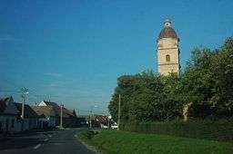
A Roman Catholic church of Saint George was built in 1676, and a chateau in 1844.
Geography
The municipality lies at an altitude of 168 metres and covers an area of 39.719 km². It has a population of about 1550 people.
Genealogical resources
The records for genealogical research are available at the state archive "Statny Archiv in Bratislava, Slovakia"
- Roman Catholic church records (births/marriages/deaths): 1633-1938 (parish A)
External links
See also
Municipalities of Senica District | ||
|---|---|---|