Boston Elevated Railway

The Boston Elevated Railway (BERy) was a streetcar and rapid transit railroad operated on, above, and below, the streets of Boston, Massachusetts and surrounding communities. Founded in 1894, it eventually acquired the West End Street Railway via lease and merger to become the city's primary mass transit provider. Its modern successor is the state-run Massachusetts Bay Transportation Authority (MBTA), which continues to operate in part on infrastructure developed by BERy and its predecessors.
History
Originally intended to build a short electric trolley line to Brookline, the West End Street Railway was organized in 1887. By the next year it had consolidated ownership of a number of horse-drawn streetcar lines, composing a fleet of 7816 horses and 1480 rail vehicles. As the system grew, a switch to underground pulled-cable propulsion (modeled after the San Francisco cable cars) was contemplated. After visiting Frank Sprague and witnessing the Richmond, Virginia system in action, WESR President Henry Whitney chose to deploy electric propulsion systems. A section of track was used to test the Bentley-Knight underground power line, but this was abandoned because of failures and safety concerns (especially after the electrocution of a team of horses in 1889). After competing in operational tests with the Sprague streetcar system, the Thomson-Houston company was chosen for system-wide deployment of overhead wires.[1] The electrified rapid transit system was named an IEEE Milestone in Electrical Engineering in 2004.[2]
The first electric trolley line built by the West End Street Railway was between Union Square, Allston and Park Square, downtown, via Harvard Street, Beacon Street, Massachusetts Avenue and Boylston Street. Trolleys first ran in 1889. The Green Line "A" Branch later served roughly the same purpose.
The last horse car line was along Marlborough Street in the Back Bay, and was never electrified. It was closed around 1900.[3]
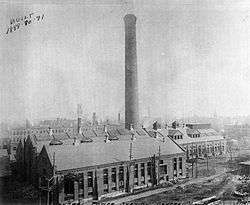
In the late 19th century, the electric power industry was in its infancy; the power grid as we know it today simply did not exist. The railway company constructed its own power stations; by 1897, these included distributed generation stations in downtown Boston, Allston, Cambridge (near Harvard), Dorchester, Charlestown, East Cambridge, and East Boston. By 1904, the system had 36 megawatts of generating capacity, 421 miles (678 km) of track for over 1550 street cars (mostly closed but some open), and 16 miles (26 km) of elevated track for 174 elevated cars.[1]
On 7 November 1916, Boston Elevated Railway Co. street car No. 393 smashed through the warning gates of the open Summer Street drawbridge in Boston, plunging into the frigid waters of Fort Point Channel, killing 46 people. [4]
The first bus route was in 1922, between Union Square, Allston and Faneuil Street. In 1933 this was merged with the Union Square - Central bus and later became the 64 bus. [5]
Elevated railway
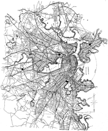
In 1890, the West End Railway was authorized by the state to construct elevated railways, but did not pursue this possibility. The state consequently authorized a new franchise for such an endeavor, which resulted in the founding in 1894 in the establishment of the Boston Elevated Railway. The first stretch of elevated track was put in service in 1901, between Sullivan Square in Charlestown and Dudley Square in Roxbury. In 1897, BERy acquired a long-term lease on the West End's lines, and the two companies were formally merged in 1922. The elevated network was expanded to include six end-points, with vehicles run on the tracks in routes design to reach any destination without changing.
Power generation
The difficulty of transporting coal over land from the Port of Boston and the short range of the direct current system prevented significant expansion inland. In 1911, a large generating station was built in South Boston which produced 25 Hertz alternating current, which could be transmitted long distances at high voltage, to substations which would drop the voltage for use by trains. The system was gradually converted until completion in 1931, when 14 substations were in place. This station would operate until 1981, when the MBTA decided to purchase energy from local utility companies instead of running its own generators.[1]
Conversion of routes to trolleybuses and buses
The first route of the Boston trackless trolley system was opened by BERy, on April 11, 1936. It was route 77 (later 69), Harvard – Lechmere via Cambridge Street. Trackless trolleys still run from Harvard station, but only to the west and north, not east to Lechmere since 1963.
Operations
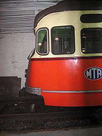
The company's rapid transit lines have evolved into the Red, Blue, and Orange Lines. The only streetcars that remain are the various branches of the Green Line and the Ashmont-Mattapan High Speed Line; the rest have been converted to buses.
The Boston Elevated Railway operated in the following cities and towns:
- Arlington
- Belmont
- Boston and the municipalities that have been merged into it
- Brookline
- Cambridge
- Chelsea
- Everett
- Malden
- Medford
- Newton (only to get between Boston and Watertown)
- Revere
- Somerville
- Stoneham (only the southern bit, in the Middlesex Fells)
- Watertown
Additionally, streetcars from adjoining towns, run by other companies, operated over Boston Elevated Railway trackage.
Operations of the company were taken over by the Metropolitan Transit Authority, now the MBTA, in 1947.
References
- 1 2 3 History of electrification of the West End Street Railway Archived October 2, 2006, at the Wayback Machine.
- ↑ "Milestones:Power System of Boston's Rapid Transit, 1889". IEEE Global History Network. IEEE. Retrieved 28 July 2011.
- ↑ Closure
- ↑ "Street Car Plunge 46 Drowned". Boston Globe. 29 October 2016. Retrieved 17 November 2016.
- ↑ bus
Further reading
- Cheney, Frank; Sammarco, Anthony Mitchell (2000). When Boston rode the El. Charleston, SC: Arcadia. ISBN 978-0-7385-0462-9.
External links
| Wikimedia Commons has media related to Boston Elevated Railway. |
- The Boston Elevated Railway Company. Library records, 1884-1967 [bulk 1921-1950] are located in the Northeastern University Libraries, Archives and Special Collections Department, Boston, MA.
| Subway lines (List of stations) |
| |||||||||||
|---|---|---|---|---|---|---|---|---|---|---|---|---|
| Commuter Rail lines (List of stations) |
| |||||||||||
| Bus routes (List of routes) | ||||||||||||
| Other services | ||||||||||||
| Component parts of system lines | ||||||||||||
| Capital projects |
| |||||||||||
| History |
| |||||||||||
| Other | ||||||||||||