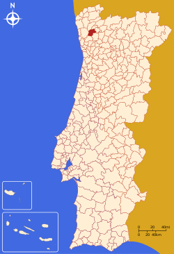
Braga
| Braga | |||
|---|---|---|---|
| Municipality | |||
|
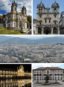
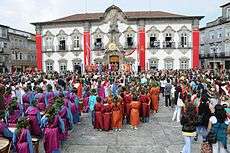
From left to right: Bom Jesus do Monte, Braga Cathedral, Braga Baixa, Republic Square, Municipal Palace | |||
| |||
 | |||
| Coordinates: 41°33′4″N 8°25′42″W / 41.55111°N 8.42833°WCoordinates: 41°33′4″N 8°25′42″W / 41.55111°N 8.42833°W | |||
| Country |
| ||
| Region | Norte | ||
| Subregion | Cávado | ||
| Intermunic. comm. | Cávado | ||
| District | Braga | ||
| Parishes | 37, see text | ||
| Government | |||
| • President | Ricardo Bruno Antunes Machado Rio (PSD) | ||
| Area | |||
| • Total | 183.40 km2 (70.81 sq mi) | ||
| Elevation | 200 m (700 ft) | ||
| Highest elevation | 558 m (1,831 ft) | ||
| Population (2011) | |||
| • Total | 181,494 | ||
| • Density | 990/km2 (2,600/sq mi) | ||
| Time zone | WET/WEST (UTC+0/+1) | ||
| Postal code | 470x | ||
| Area code | 253 | ||
| Website |
www | ||
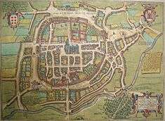
Braga [Portuguese pronunciation: [ˈbɾaɣɐ]] (Latin: Bracara Augusta) is a city and a municipality in the northwestern Portuguese district of Braga, in the historical and cultural Minho Province. The city has 137,000 inhabitants, and the municipality, which includes 37 civil parishes has a resident population of 181,494 inhabitants (in 2011),[1] representing the seventh largest municipality in Portugal (by population). Its area is 183.40 km².[2] Its agglomerated urban area extends from the Cávado River to the Este River. The city was the European Youth Capital in 2012.[3] It is host to the archdiocese, the oldest in Portugal. Under the Roman Empire, known as Bracara Augusta, the settlement was centre of the province of Gallaecia. Braga is a major hub for inland Northern Portugal.
History


Antiquity
Human occupation of the region of Braga dates back thousands of years, documented by vestiges of monumental structures starting in the Megalithic era. During the Iron Age, the Castro culture extended into the northwest, characterized by Bracari peoples who occupied the high ground in strategically located fortified settlements (castrum). The region became the domain of the Callaici Bracarii, or Bracarenses, a Celtic tribe who occupied what is now northern Portugal, Galicia and Asturias in the north west of Iberia.
The Romans began their conquest of the region around 136 BC, and finished it during the reign of Emperor Augustus. The civitas of Bracara Augusta was founded in 20 BC; in the context of the administrative reorganization of these Roman acquisitions, Bracara was re-dedicated to the Emperor taking on the name Bracara Augusta. The city of Bracara Augusta developed greatly during the 1st century and reached its maximum extension around the 2nd century. Towards the end of the 3rd century, Emperor Diocletianus promoted the city to the status of capital of the administrative area Conventus bracarensis, the south western area of the newly founded Roman province of Gallaecia.
Middle Ages
During the Germanic Invasions of the Iberian Peninsula, the area was conquered by the Suebi, a Germanic people from Central Europe. In 410, the Suebi established a Kingdom in northwest Iberia, which they maintained as Gallaecia, and made Bracara their capital. About 584, the Visigothic conquerors of Hispania took control of Gallaecia. They renounced the Arian and Priscillianist hearesies during two synods held here in the 6th century. As a consequence, the archbishops of Braga later claimed the title of Primate of Portugal, then a county, and for a long period, claimed supremacy over the entire Hispanic church. Yet, their authority was never accepted throughout Hispania.

Braga had an important role in the Christianization of the Iberian Peninsula. The first known bishop of Braga, Paternus, lived at the end of the 4th century, although Saint Ovidius (d. 135 AD) is sometimes considered one of the first bishops of this city. In the early 5th century, Paulus Orosius (a friend of Augustine of Hippo) wrote several theological works that expounded the Christian faith, while in the 6th century Bishop Martin of Braga converted the Suebi from Arianism to Catholicism. At the time, Martin also founded an important monastery in Dumio (Dume), and it was in Braga that Archbishopric of Braga held their councils.
The transition from Visigothic reigns to the Muslim conquest of Iberia was very obscure, representing a period of transition and decline for the city. The Moors captured Braga early in the 8th century, but were eventually repelled by Christian forces under Alfonso III of Asturias in 868 and were definitely repelled by Ferdinand I of León and Castile in 1040. As a consequence, the bishopric was restored in 1070: the first new bishop, Pedro, started rebuilding the Cathedral (which was modified many times during the following centuries).
Between 1093 and 1147, Braga became the residencial seat of the Portuguese court. In the early 12th century, Count Henry of Portugal and bishop Geraldo de Moissac reclaimed the archbishopric seat for Braga, with power over a large area in Iberia. The medieval city developed around the cathedral, with the maximum authority in the city retained by the archbishop.
Kingdom
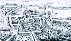
In the 16th century, due to its distance from the coast and provincial status, Braga did not profit from the adventures associated with the Age of Portuguese Discoveries (which favoured cities like Lisbon, Évora and Coimbra, seats of the Portuguese court). Yet, Archbishop Diogo de Sousa, who sponsored several urban improvements in the city, including the enlargement of streets, the creation of public squares and the foundation of hospitals and new churches managed to modernize the community. He expanded and remodelled the cathedral by adding a new chapel in the Manueline style, and generally turning the mediaeval town into a Renaissance city.
A similar period of rejuvenation occurred during the 18th century, when the archbishops of the House of Braganza contracted architects like André Soares and Carlos Amarante, to modernize and rejuvenate the city; they began a series of architectural transformations to churches and civic institutions in the Baroque style, including the municipal hall, public library, the Sanctuary of Bom Jesus do Monte and many urban palaces.
With the invasion of French troops, during the Peninsular Wars the city was relegated, once again, to a provincial status. But, by the second half of that century, with influence from Portuguese immigrants living in Brazil, new money and tastes resulted in improvements to architecture and infrastructures.
Republic
In the 20th century Braga faced similar periods of growth and decline; demographic and urban pressures, from urban-to-rural migration meant that the city's infrastructures had to be improved in order to satisfy greater demands.
Geography
Physical geography
.jpg)
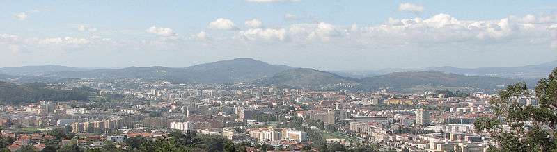
Situated in the heart of Minho, Braga is located in a transitional region between the east and west: between mountains, forests, grand valleys, plains and fields, constructing natural spaces, moulded by human intervention. Geographically, with an area of 184 square kilometres (71 sq mi) it is bordered in the north by the municipalities of Vila Verde and Amares, northeast and east by Póvoa de Lanhoso, south and southeast with Guimarães and Vila Nova de Famalicão and west by the municipality of Barcelos.[4]
The topography in the municipality is characterized by irregular valleys, interspersed by mountainous spaces, fed by rivers running in parallel with the principal rivers. In the north it is limited by the Cávado River, in the south by terrain of the Serra dos Picos to a height of 566 metres (1,857 ft) and towards the east by the Serra dos Carvalhos to a height of 479 metres (1,572 ft), opening to the municipalities of Vila Nova de Famalicão and Barcelos. The territory extends from the northeast to southwest, accompanying the valleys of the two rivers, fed by many of its tributaries, forming small platforms between 20 metres (66 ft) and 570 metres (1,870 ft).
The municipality lies between 20 metres (66 ft) and 572 metres (1,877 ft), with the urbanized centre located at approximately 215 metres (705 ft). In the north, where the municipality is marked by the Cavado, the terrain is semi-planar, the east is mountainous owing to the Serra do Carvalho 479 metres (1,572 ft), Serra dos Picos 566 metres (1,857 ft), Monte do Sameiro 572 metres (1,877 ft) and Monte de Santa Marta 562 metres (1,844 ft). Between the Serra do Carvalho and Serra dos Picos is the River Este, forming the valley of Vale d’Este. Similarly, between the Serra dos Picos and Monte do Sameiro exists the plateau of Sobreposta-Pedralva. To the south and west, the terrain is a mix of mountains, plateaus and medium-size valleys, permitting the passage of the River Este, and giving birth to other confluences including the River Veiga, River Labriosca and various ravines.
Climate
Braga has a Mediterranean climate (Köppen Csb) similar to other cities in the northwest Iberian Peninsula except for having significantly hotter summer temperatures due to being some distance from the ocean: the absolute maximum is as much as 6 °C (11 °F) higher than for A Coruña or Santiago de Compostela. The highest recorded temperature is 41.3 °C (106.3 °F) while the lowest recorded is −6.3 °C (20.7 °F). The climate is affected by the Atlantic Ocean which influences westerly winds that are channeled through the region's valleys, transporting large humid air masses. Consequently, the climate tends to be pleasant with clearly defined seasons. The air masses have the effect of maintaining the relative humidity around 80%: annual mean temperatures hover between 12.5 °C (54.5 °F) and 17.5 °C (63.5 °F). Owing to nocturnal cooling, frost usually forms frequently between three and four months of the year (about 30 days of frost annually), and annually the region receives 1,659 millimetres (65.3 in) of precipitation, with the major intensity occurring between fall/winter and spring.
| Climate data for Braga | |||||||||||||
|---|---|---|---|---|---|---|---|---|---|---|---|---|---|
| Month | Jan | Feb | Mar | Apr | May | Jun | Jul | Aug | Sep | Oct | Nov | Dec | Year |
| Record high °C (°F) | 24.0 (75.2) |
23.5 (74.3) |
29.5 (85.1) |
31.0 (87.8) |
35.5 (95.9) |
38.5 (101.3) |
38.5 (101.3) |
42.2 (108) |
38.5 (101.3) |
33.3 (91.9) |
28.5 (83.3) |
24.1 (75.4) |
39.5 (103.1) |
| Average high °C (°F) | 13.7 (56.7) |
14.8 (58.6) |
17.6 (63.7) |
18.3 (64.9) |
21.1 (70) |
25.4 (77.7) |
27.8 (82) |
28.0 (82.4) |
25.5 (77.9) |
20.9 (69.6) |
16.8 (62.2) |
14.4 (57.9) |
20.3 (68.5) |
| Daily mean °C (°F) | 9.0 (48.2) |
9.9 (49.8) |
12.3 (54.1) |
13.2 (55.8) |
15.8 (60.4) |
19.5 (67.1) |
21.4 (70.5) |
21.4 (70.5) |
19.4 (66.9) |
15.9 (60.6) |
12.3 (54.1) |
10.2 (50.4) |
15.0 (59) |
| Average low °C (°F) | 4.3 (39.7) |
4.9 (40.8) |
7.0 (44.6) |
7.9 (46.2) |
10.4 (50.7) |
13.5 (56.3) |
14.9 (58.8) |
14.7 (58.5) |
13.2 (55.8) |
10.8 (51.4) |
7.7 (45.9) |
6.0 (42.8) |
9.6 (49.3) |
| Record low °C (°F) | −6.3 (20.7) |
−4.5 (23.9) |
−5.0 (23) |
−1.2 (29.8) |
−0.5 (31.1) |
3.3 (37.9) |
7.5 (45.5) |
6.7 (44.1) |
3.8 (38.8) |
2.5 (36.5) |
−1.7 (28.9) |
−2.5 (27.5) |
−6.3 (20.7) |
| Average precipitation mm (inches) | 176.4 (6.945) |
114.8 (4.52) |
121.6 (4.787) |
130.8 (5.15) |
112.9 (4.445) |
48.6 (1.913) |
22.0 (0.866) |
34.0 (1.339) |
81.7 (3.217) |
191.7 (7.547) |
193.9 (7.634) |
220.2 (8.669) |
1,448.6 (57.031) |
| Source: Instituto de Meteorologia, IP Portugal[5] | |||||||||||||
Human geography

|
|
The municipality is densely populated, with approximately 962 inhabitants per square kilometre, equivalente to 181,474 residents (2011); it is one of the more populous territories in Portugal, as well as one of the "younger" markets.[6] The majority of the population concentrates in the urban area of Braga, itself, where densities are more than 10000 per square kilometre.
The Bracarense population consists of approximately 78954 male and 85238 female individuals, with 35% of the population less than 25 years of age, while seniors conform to 11% of the population; the working population of the municipality occupies 54% of this structure.[6] Although largely native Portuguese, other segments of the population include enclaves of Brazilian, African (principally from the former Portuguese colonies), Chinese and eastern European peoples.[6]
The urban structure includes approximately 70,268 residences (2001), even as the typical classic representation of family only includes 51,173 members in the municipality.[6] The "extra" homes are primarily temporary residences, normally for students, migrant workers and professionals working in the urban congrum. There is, also, a great number of homes owned by Portuguese residents living overseas (who use the homes periodically while in Portugal) even as constant and development has attracted new growth in the population.[6] Further, the difference in resident to tranistory population means that, on average, the population of Braga hovers between 174,000 and 230,000 individuals annually.[6]
Growth in the population, roughly 16.2% between 1991 and 2001, occurred mainly in the older suburban civil parishes, such as Nogueira (124.6%), Frossos (68.4%), Real (59.8%) and Lamaçães (50.9%).[6]
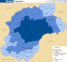
Administratively, the municipality is divided into 37 civil parishes (freguesias):[7]
- Adaúfe
- Arentim e Cunha
- Braga (Maximinos, Sé e Cividade)
- Braga (São José de São Lázaro e São João do Souto)
- Cabreiros e Passos (São Julião)
- Celeirós, Aveleda e Vimieiro
- Crespos e Pousada
- Escudeiros e Penso (Santo Estêvão e São Vicente)
- Espinho
- Esporões
- Este (São Pedro e São Mamede)
- Ferreiros e Gondizalves
- Figueiredo
- Gualtar
- Guisande e Oliveira (São Pedro)
- Lamas
- Lomar e Arcos
- Merelim (São Paio), Panoias e Parada de Tibães
- Merelim (São Pedro) e Frossos
- Mire de Tibães
- Morreira e Trandeiras
- Nogueira, Fraião e Lamaçães
- Nogueiró e Tenões
- Padim da Graça
- Palmeira
- Pedralva
- Priscos
- Real, Dume e Semelhe
- Ruilhe
- Santa Lucrécia de Algeriz e Navarra
- São Vicente
- São Victor
- Sequeira
- Sobreposta
- Tadim
- Tebosa
- Vilaça e Fradelos
The city of Braga proper includes only the following urban civil parishes:
There is no formal city government, only municipal government authority, with local administration handled by the individual juntas de freguesia or civil parish councils.
Economy
The major industries in the municipality are construction, metallurgy and mechanics, software development and web design. The computer industry is growing rapidly.
Transportation
Although the region hosts its own airfield (Aerodromo de Braga) in Palmeira, the principal airport of note is Sá Carneiro International Airport located 50 kilometres (31 mi) away, in Porto. Access is made by public transit to the city centre (roughly 20 minutes) or Aerobus (30 minutes). Braga is serviced by both regional and high-speed rail connection to major centres in the region.
Architecture
.JPG)
The region of Braga is scattered with Neolithic, Medieval and Modernist monuments, buildings and structures that permeates its historical character, attracting tourism and promoting the areas cultural heritage. Although there are many examples of these structures, only the following have been classified by the Instituto de Gestão do Património Arquitectónico e Arqueológico as National Monuments:
Archaeological
- Castro of São Mamede (Castro de Monte Redondo/Castro Monte Cossourado/Castro de São Mamede)
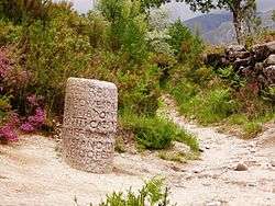
- Roman milestones, several Roman-era granite markers currently on display at the Museum D. Diogo de Sousa, dating from AD 41 to 238, that is, the reigns of Emperor Claudius to Maximinus II.[8]
- Roman Thermae of Maximinus (Portuguese: Termas romanas de Maximinos/Alto da Cividade/Colina dos Maximinos), discovered in the 20th century, the thermae occupy 800 square metres (8,600 sq ft), in the civil parish of Cividade, and were constructed in the 1st to late 3rd century;[9]
Civic
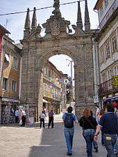
- Arch of Porta Nova/Rua de Souto (Arco da Porta Nova/Arco da Rua do Souto), a Baroque and Neoclassical arch, designed by André Soares in the late 18th century, and decorates the western gate of a medieval wall. It was opened in 1512 and since has been traditionally used to present to promote to visiting dignitaries and celebrities.[10]
- Palace of the Falcões (Portuguese: Palácio dos Falcões/Governo Civil de Braga), a Baroque-era palace originally commissioned by Francisco de Meira Carrilho on 23 July 1703, and later, upon successive renovations, used by the Civil Governor's residence;
- Fountain of the Idol (Portuguese: Fonte do Ídolo), the 1st century Roman fountain dedicated to an indigenous god, located in the central civil parish of São José de São Lázaro;
- Fountain of the Iron Waters (Portuguese: Fonte das Águas Férreas), following the discovery in July 1173 of iron-rich springs in the parish of Fraião, Archbishop Gaspar de Bragança ordered the municipal council to begin the canalization of these waters for public use, giving rise to a series of fountains, such as the Baroque decorated main fountain;
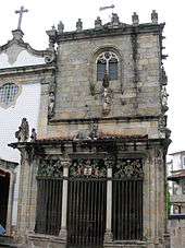
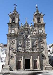
- Hospital of São Marcos (Portuguese: Hospital de São Marcos), with a façade comparable to any religious monument in the city, the Hospital of São Marcos, is an example of the complex Baroque style of Carlos Amarante, featuring ornate double belfry and accents;
- Pillory of Braga (Portuguese: Pelourinho de Braga), the 15th century pillory, that marks municipal authority for the town, was constructed, demolished and moved various times, before being relocated on the grounds of the Sé Cathedral;[11]
- Palace of Raio (Portuguese: Palácio de Raio), an 18th-century Baroque-Rococo urban residence, with richly decorated blue azulejo façade of Andre Soares;
- Residence of the Crivos (Portuguese: Casas das Gelosias/Casa dos Crivos), a Renaissance-era shop-residence constructed outside the old walls characteristic of late Renaissance architecture and one of the few examples of a building covered in wood-lattice façade from this period.
- Seven Sources Aqueduct (Portuguese: Sete Fontes), a complex network of aqueducts that provided potable water to citizenry of Braga;
- Theatro Circo (Portuguese: Teatro Circo de Braga), 20th century revivalist theatre, known for its architecture, as much for the films, theatre plays and performances;
- Bridge of Prado (Ponte do Prado)
- Bridge of Prozelo (Ponte de Prozelo/Ponte do Porto)
Military
- Tower of Santiago (Portuguese: Torre de Santiago e troço das antigas muralhas de Braga), part of the ancient walls of Braga, the Tower of Santiago was designed by Portuguese Baroque master André Soares, based on a mixture of Gothic, Baroque and Rococo elements;
- Tower of Castle of Braga (Castelo de Braga), actually the remnants of the castle's keep, constructed during the reign of King Denis of Portugal, which was part of the defensive system of the city of Braga, and included a semi-circular walled enclosure centred on the Sé Cathedral.[12]
Religious

- Archiepiscopal Palace of Braga (Portuguese: Antigo Paço Arquiepiscopal de Braga), between the 14th–18th centuries, a religious residence, but after the 20th century, the home of the municipal offices, public library and archive;
- Chapel of the Espírito Santo (Portuguese: Capela do Espírito Santo), an example of mixed styles, the chapel includes elements of Baroque, Neoclassical and Mannerist eras;
- Chapel of Nossa Senhora da Consolaçã (Portuguese: Capela de Nossa Senhora da Consolação), a simple single-nave chapel constructed in the Baroque-style
- Chapel of São Bento (Portuguese: Capela de São Bento), constructed in the middle of the 18th century, the chapel was blessed by Archbishop José of Bragança in 1755;
- Chapel of Senhor do Bom Sucesso (Portuguese: Capela do Senhor do Bom Sucesso), a Baroque and Neoclassical chapel, is highlighted by a main façade, typical of André Soares, but constructed by Carlos Amarante, at the beginning of his career, who timidly applied Neoclassical decorative elements;
- Chapel of the Coimbras (Capela de Nossa Senhora da Conceição/Capela dos Coimbras/Capela do Senhor Morto), a Manueline chapel, probably designed by Castillian architect Filipe Odarte, with sculptures attributed to Hodart, an altar by João de Ruão and posterior tomb sculptures by the same artist.[13]
- Church of Santa Cruz (Portuguese: Igreja de Santa Cruz), and the Hospital of the Brotherhood of the Holy Cross of Jerusalem (Portuguese: Irmandade de Santa Cruz de Jerusalem), constructed in 1581, and later supported by the nuns of the Order Hospitaler;
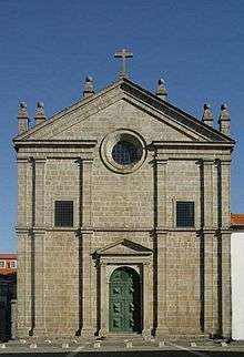
- Church of Santa Eulália (Portuguese: Igreja de Santa Eulália), is a 13th-14th century Romanesque church, located near Bom Jesus do Monte;
- Church of Santa Maria (Portuguese: Igreja Paroquial de Ferreiros/Igreja de Santa Maria), constructed in 1560, under the orders of Archibishop Bartolomeu dos Mártires, as a church of the Society of Jesus;
- Church of Santo André (Portuguese: Igreja Paroquial de Gondizalves/Igreja de Santo André), an example of the reforumulations of the Modernist aesthetic of the mid-20th century, the 18th-century church was adapted and expanded after the parishes deannexation in 1975;
- Chapel of São Frutuoso, also known as the Chapel of São Frutuoso of Montélios or the Chapel of São Salvador of Montélios, is a pre-Romanesque chapel, forming part of group of religious buildings that include the Royal Church originally built by the Visigoths in the 7th century, in the form of a Greek cross.[14]
- Chapel of São Sebastião das Caravelheiras (Portuguese: Capela de São Sebastião das Caravelheiras)
- Church of São Martinho (Portuguese: Igreja Matriz de Espinho/Igreja de São Martinho), the Baroque and Classical parochial church of Espinho, known for its ornate façade and belfrey, as well as its Rococo interior;
- Church of São Miguel de Frossos (Portuguese: Igreja Paroquial de Frossos/Igreja de São Miguel), a 16th-century parochial church in the civil parish of Frossos;
- Church of São Miguel de Gualtar (Portuguese: Igreja Paroquial de Gualtar/Igreja de São Miguel), part of the intense building period of the 16th-17th century, the parochial church of Gultar was constructed in the 17th century, but later remodelled during the 18th century;
- Church of São Paio (Portuguese: Igreja Paroquial de Arcos/Igreja de São Paio), located in Arcos, the church is an early 18th-century church (built in 1706);
- Church of São Paulo (Portuguese: Igreja de São Paulo e Seminário de Santiago), the historical seminary and church of Saint Paul with its contrast between stoic façade and decorated Baroque interior, built in the era of archbishop Bartholomew;
- Church of São Pedro de Lomar (Portuguese: Igreja de São Pedro de Lomar), remnant of ancient Benedictine monastery of São Pedro in Lomar, the Church of Saint Peter exemplifies a mix of Baroque, Mannerist and Neoclassical architecture;
- Church of São Pedro de Maximinos (Portuguese: Igreja de São Pedro de Maximinos), known for the missing organ of organist Manuel de Sá Couto;
- Church of São Tiago (Portuguese: Igreja Paroquial da Cividade/Igreja de São Tiago)
- Church of São Vicente (Portuguese: Igreja de São Vicente)
- Convent of Nossa Senhora do Carmo (Portuguese: Convento de Nossa Senhora do Carmo), principally recognizable for its central spire/belfrey, which was designed by João de Moura Coutinho de Almeida e Eça, and constructed in the 17th-18th century;
- Church of the Misericórdia (Portuguese: Igreja da Misericórdia)
- Church of the Third Order of St. Francis (Portuguese: Igreja dos Terceiros), the Terceiros began the process of constructing their church in 1685, which they dedicated to Our Lady of Conception (Portuguese: Nossa Senhora da Conceição;
- Church, Convent and College of the Congregation of São Filipe de Néri (Portuguese: Igreja dos Congregados), attributed to the architect André Soares, for the complex/risky façade of the church and corner convent windows, Monk's chapel (or Chapel of Our Lady of the Appearance), and retable of Our Lady of Pain (Portuguese: Nossa Senhora das Dores)
- Convent of Nossa Senhora da Conceição (Portuguese: Convento da Nossa Senhora da Conceição), which includes the Chapel of São Domingos, an 18th-century convent, home to the Instituto Monsenhor Ariosa;
- Convent of Pópulo (Portuguese: Convento do Pópulo), the Mannerist, Baroque, Rococo and Neoclassical austere elements of the convent belying the extravagant interior, that was originally the home to Augustine monks, highlighted by the Baroque façade of the Church of Pópulo (Portuguese: Igreja de Pópulo);
- Convent of Salvador (Portuguese: Convento do Salvador/Lar Conde de Agrolongo), began with the need to transfer the nuns from the Monastery of Vitorino das Donas in 1528
- Convent of São Francisco de Montélios (Portuguese: Convento de São Francisco/Igreja de São Jerónimo de Real), the Baroque, Rococo and Neoclassical convent, highlighted by the imposing three-storey façade of the Church of São Jerónimo;
- Cross of Nossa Senhora dos Aflitos (Portuguese: Cruzeiro da Nossa Senhora dos Aflitos), a Baroque cross on an ionic column, with an image of Christ in wood, surmounted by a rectangular Tuscan colonnade and roof;
- Cross of the Espírito Santo (Portuguese: Cruzeiro do Espírito Santo)
- Monastery of Dumio (Portuguese: Ruínas Arqueológicas de São Martinho de Dume), the ancient religious seat founded by Martin of Braga in the provincial centre of Dume;
- Monastery of Tibães (Portuguese: Mosteiro de Tibães), the 17th–18th century Benedictine monastery renowned for the ornate/artistic gilt work in its chancel and altars;
- Sanctuary of Bom Jesus do Monte, constructed on Monte Santo, overlooking the urban sprawl of Braga, the 18th to early-19th century, Neoclassic sanctuary and church (itself preceded by Baroque stairway), is reachable by trail or Bom Jesus funicular (one of the oldest in Iberian Peninsula);
- Sanctuary of Nossa Senhora do Sameiro (Portuguese: Santuário de Nossa Senhora do Sameiro), isolated on the hilltop of Monte do Sameiro, the church and retreat began in 1861, from the mind of Father Martinho António Pereira da Silva, who wished to construct a monument dedicated to Our Lady of the Conception;
- Sanctuary of Santa Maria Madalena (Portuguese: Santuário de Santa Maria Madalena/Santuário da Falperra), located on Monte Falperra, the Baroque-era sanctuary church, was designed by local architect André Soares, incorporating decorative elements into a two-bell tower homage to the Mary Magdalene;
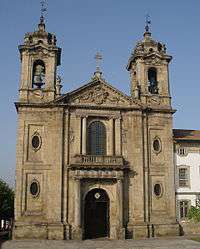
- Sé Cathedral of Braga (Portuguese: Sé Catedral de Braga)
- Wayside shrine of São Brás (Portuguese: Alminhas de São Brás), although conjecturally a contemporary monument, the wayside shrine in Ferreiros has the characteristics of many Baroque monuments in Braga;
- Cross of Campo das Hortas (Cruzeiro do Campo das Hortas)
- Cross of Santana (Cruzeiro de Santa Ana/Cruzeiro de Santana)
- Cross of Tibães (Cruzeiro de Tibães)

Museums
In addition, many of the district's treasures and historical artifacts are housed in several museums that are scattered throughout the city, such as:
- Museum of the Biscainhos (Portuguese: Museu dos Biscainhos, housed in the historical Palace of the Biscainhos, the museum exhibits a permanent collection of decorative art, that includes furniture, ceramics, European and Oriental porcelain, European Glass, European and Portuguese watches and clocks;
- Treasure Museum of the Sé Cathedral (Portuguese: Tesouro Museu da Sé Catedral), the collection varies, but collects together artefacts from the 16th to 18th century during the period of religious/cultural exploration, associated with the Cathedral, including images and azulejo tiles;
- Museum of Image (Portuguese: Museu da Imagem), dedicated to photography, located near the Arco da Porta Nova and Braga Castle;
- Museum Medina (Portuguese: Museu Medina), located in the same building as the Museum of Pius XII, the collection is the home to the 83 oil paintings and 21 drawings of the painter Henrique Medina;
- Museum of Nogueira da Silva (Portuguese: Museu Nogeuira da Silva), bequeathed to the University of Minho, the collection includes artefacts, paintings, furniture and sculptures collected over a lifetime, such as Renaissance artwork, 17th furniture, ceramics and objects in ivory, silver and religious art;
- Museum of Pius XII (Portuguese: Museu Pio XII), housing a collection of Palaeolithic, Neolithic and Bronze Age implements, Pre-historic and Luso-Roman pottery;
- D. Diogo de Sousa Museum (Portuguese: Museu D. Diogo de Sousa), its collection includes many items discovered during archaeological excavations within the municipality, extending as far back as the Palaeolithic to the Middle Ages.
- Museum of String Instruments (Portuguese: Museu dos Cordofones), the collection features Portuguese instruments as far back as the Middle Ages including Cavaquinhos, Portuguese guitars, Mandolins and banjos among others.
Education
%2C_Braga.jpg)
The city is the headquarters and main campus for the Universidade do Minho (Minho University), a public university founded in 1973. A campus of Portugal's oldest private university of Portugal, the Universidade Católica Portuguesa, was also established in 1967, as well as the Escola Secundária Sá de Miranda (the oldest Secondary school in Braga).
In the late 2000s, the International Iberian Nanotechnology Laboratory also opened their international research centre in the city.
The Braga Pedagogical Farm is a farm dealing with animals and agriculture, welcoming extra-curricular activities from schools and visitors.
Sports
Braga's football team, Sporting Clube de Braga, was founded in 1921 and play in the top division of Portuguese football, the Liga Sagres, from Braga Municipal Stadium, carved out of the Monte Castro hill that overlooks the city. Braga has had considerable success in recent years, winning the Taca de Portugal for the second time in 2016 and reaching the Europa League final in 2011 which they lost to fellow Portuguese side FC Porto.
The Rampa da Falperra, a round of the European Hillclimb Championship, is held every year in the outskirts of the city.
The Circuito Vasco Sameiro and adjacent the Kartódromo Internacional de Braga are located around the local airfield. The racing track held European Touring Car Cup events in 2009 and 2010, and the KIB has held rounds of the Karting World Championship.
Notable citizens
- Paulus Orosius (c. 385 – c. 420): Important historian and theologue from the Braga diocese, friend of St. Augustine.
- Martin of Braga (c. 520 – 580): Bishop of Braga that converted the Suebi to Catholicism.
- Diogo de Sousa (c. 1461 – 1532): Archbishop of Braga after 1505. A great sponsor of the arts, he remodelled the Cathedral and promoted the urbanisation of the city following Renaissance models. He also founded several churches and an important school (the São Paulo School).
- Francisco Sanches (c.1550 – c.1623), born Sephardi Jew and New Christian, physician and philosopher, educated in universities in France and Italy, and responsible for Quod Nihil Scitur (That Nothing Is Known), written in 1576 and published in 1581 a skepticial treasties on science;
- André Soares (1720–1769): 18th-century architect, designed several important Rococo buildings in Braga and northern Portugal, including the Palace of Raio, Monastery of Tibães, Church of Falperra, and Porta Nova Arch
- Irmã Maria Estrela Divina, religious and stigmatic woman. Buried in Braga Cathedral.
- Domingos Leite Pereira: Portuguese politician of the Portuguese First Republic.
- Maria Ondina Braga (13 January 1932 — 14 March 2003), an author who of A China Fica ao Lado (1968), Angústia em Pequim (1984) and Nocturno em Macau (1984), as well as a translator for the works of Graham Greene, John le Carré and Anaïs Nin
- António Variações (1944–1984) innovative pop composer and singer
- Marie Myriam (born Myriam Lopes in Braga, 8 May 1957) French singer of Portuguese origin, winner of 1977 Eurovision Song Contest with "L'oiseau et l'enfant" ("The Bird and the Child"), written by Jean Paul Cara and Joe Grace.
International relations
References
- ↑ Instituto Nacional de Estatística
- ↑ Eurostat Archived 6 September 2014 at the Wayback Machine.
- ↑ Braga 2012 Capital Europeia da Juventude (in Portuguese), Braga, Portugal, 2012, retrieved 19 April 2012
- ↑ Pereira, P. Gomes (2009), "Caracterização do Concelho de Braga", Diagnóstico do Concelho de Braga (PDF) (in Portuguese), Braga, Portugal: Unidade de Saúde Pública de Braga, retrieved 21 March 2012
- ↑ "Normals Climatológicas". Instituto de Meteorologia, IP Portugal. Retrieved 25 March 2015.
- 1 2 3 4 5 6 7 Census de 1991, 2001 e Território em números de 2004 (in Portuguese), Lisbon, Portugal: INE - Instituto Nacional de Estatistica, 2004, retrieved 24 March 2012
- ↑ Diário da República. "Law nr. 11-A/2013, pages 552 26-28" (pdf) (in Portuguese). Retrieved 18 July 2014.
- ↑ Sereno, Isabel; Dordio, Paulo (1994). SIPA, ed. "21 Marcos Miliários (série Capela) Braga incerta via (v.PT01130700002)" (in Portuguese). Lisbon, Portugal: SIPA–Sistema de Informação para o Património Arquitectónico. Retrieved 26 February 2012.
- ↑ Sereno, Isabel; Dordio, Paulo (1994), SIPA, ed., Termas romanas de Maximinos/Alto da Cividade/Colina dos Maximinos (v.PT010303070040) (in Portuguese), Lisbon, Portugal: SIPA – Sistema de Informação para o Património Arquitectónico, retrieved 26 April 2012
- ↑ Sereno, Isabel; Leão, Miguel; Basto, Sónia (2010). SIPA, ed. "Arco da Porta Nova/Arco da Rua do Souto (v.PT01130700002)" (in Portuguese). Lisbon: SIPA–Sistema de Informação para o Património Arquitectónico. Archived from the original on 17 March 2012. Retrieved 26 February 2012.
- ↑ Sereno, Isabel; Santos, João (1994), SIPA, ed., Pelourinho de Braga (IPA.00000207/PT010303520013) (in Portuguese), Lisbon, Portugal: SIPA – Sistema de Informação para o Património Arquitectónico, archived from the original on 21 August 2016, retrieved 15 August 2016
- ↑ Sereno, Isabel; Dordio, Paulo; Gonçalves, Joaquim (2007). SIPA, ed. "Castelo de Braga, designadamente a Torre de Menagem (restos)" (in Portuguese). Lisbon: SIPA–Sistema de Informação para o Património Arquitectónico. Archived from the original on 12 November 2013. Retrieved 26 February 2012.
- ↑ Sereno, Isabel; Santos, João (1994). SIPA, ed. "Capela de Nossa Senhora da Conceição/Capela dos Coimbras/Capela do Senhor Morto" (in Portuguese). Lisbon, Portugal: SIPA –Sistema de Informação para o Património Arquitectónico. Archived from the original on 1 April 2012. Retrieved 26 February 2012.
- ↑ Sereno, Isabel; Dordio, Paulo; Gonçalves, Joaquim (2004). SIPA, ed. "Capela de São Frutuoso de Montélios/Capela de São Salvador de Montélios" (in Portuguese). Lisbon, Portugal: SIPA – Sistema de Informação para o Património Arquitectónico. Archived from the original on 3 December 2013. Retrieved 15 November 2013.
- ↑ "Geminações de Cidades e Vilas" (in Portuguese). Associação Nacional de Municípios Portugueses. Retrieved 2015-02-11.
- ↑ "National Commission for Decentralised cooperation". Délégation pour l’Action Extérieure des Collectivités Territoriales (Ministère des Affaires étrangères) (in French). Retrieved 26 December 2013.
- ↑ "Puteaux - Qu'est-ce que le jumelage?". Mairie de Puteaux [Puteaux Official Website] (in French). Archived from the original on 26 November 2013. Retrieved 28 December 2013.
- ↑ http://www.correiodominho.com/noticias.php?id=94926
External links
| Wikimedia Commons has media related to Braga. |
-
 Braga travel guide from Wikivoyage
 - Information about Braga
- Braga Essential Guide
- Braga Portal
- Virtual Braga
- Braga city guide at HitchHikers Handbook